I have a QGIS project and I want to run a Report with PyQGIS.
The report is based on two vectors: One is "municipalities_filtred" and the other is the "sections_filtred". The join for the Report is created by the common field "comune_min" that is derived from "municipalities_filtred" and has been created even in "sections_filtred" with intersection of this last one with "municipalities_filtred".
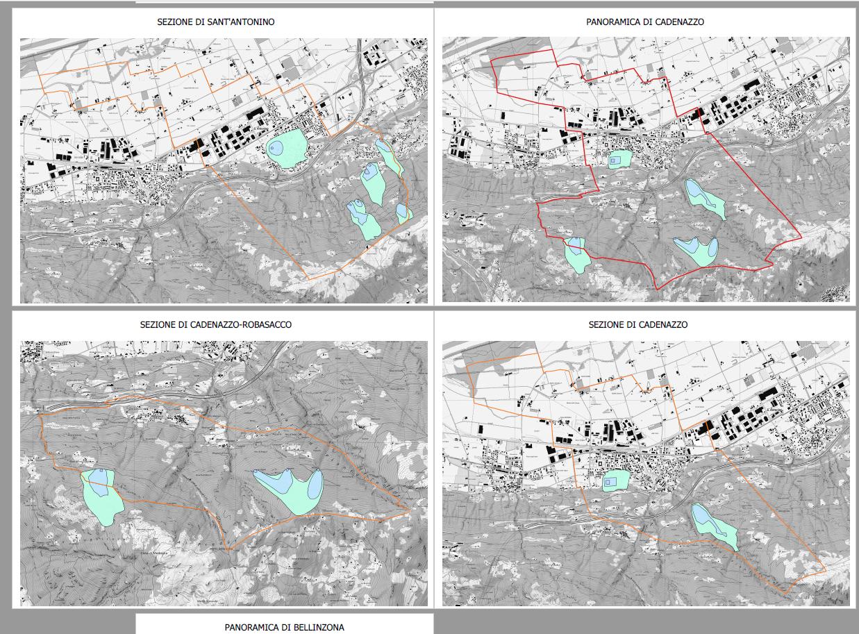
Here the image of a part of the pdf (multipage view, page 1 "SEZIONE DI SANT'ANTONINO, page 2 "PANORAMICA DI CADENZAZZO" and so on) created from the Report that is called "report.pdf"
 page with title "PANORAMICA DI CADENAZZO" is created with a coverage layer based on "municipalities_filtred".
page with title "SEZIONE DI CADENAZZO-ROBASACCO", "SEZIONE DI SANT'ANTONINO", "SEZIONE DI CADENAZZO" is created with coverage layer "sections_filtred"
The problem: I am able to create a PDF of the ENTIRE Report with the following code:
project_path = os.getcwd() + '/crdpp.qgz'

project_instance = QgsProject.instance()
project_instance.setFileName(project_path)
project_instance.read()
layoutmanager = project_instance.layoutManager()
layout = layoutmanager.layoutByName("Report")
settings = QgsLayoutExporter.PdfExportSettings()
QgsLayoutExporter.exportToPdf(layout, './report.pdf', settings)
When the code runs a long PDF file called 'report.pdf' (corresponds to image above) is created based on a layout "Report" defined before outside pyQGIS.
But I don't want to have a big PDF! I would like to export many PDFs for the report. One PDF for every feature of the common field "comune_min". One for Cadenazzo, one for Sant'Antonino and so on (see image above). Here the result of such approach and what should be the PDF for Cadenazzo. For Sant'Antonino should be another PDF.
 The filenames would be "zp_Cadenazzo.pdf" and "zp_sant'Antonino"
Then, many PDFs that are subset of 'report.pdf' like that

I have found that for the Atlas it can be done easily with this code based on https://gist.github.com/ThomasG77/28eedae0588548403aca2ba781ff443a#create-a-pdf-per-feature-of-coverage-layer:
for feature in municipalities_filtred.getFeatures():
    parameters = {'LAYOUT':'atlas',
    'COVERAGE_LAYER': municipalities_filtred,
    'FILTER_EXPRESSION':"comune_min ='{}'".format(feature['comune_min']),
    'SORTBY_EXPRESSION':'',
    'SORTBY_REVERSE':False,
    'OUTPUT':'./zp_{}.pdf'.format(feature['comune_min']),
    'LAYERS':None,
    'DPI':None,
    'FORCE_VECTOR':False,
    'GEOREFERENCE':True,
    'INCLUDE_METADATA':True,
    'DISABLE_TILED':False,
    'SIMPLIFY':True,
    'TEXT_FORMAT':0}
    out = processing.run("native:atlaslayouttopdf", parameters)
By doing that there is one PDF every feature of the coverage layer "municipalities_filtred". So, I am happy because is what I would like to do with the Report. But with the Atlas you can only work with one coverage layer, for this reason you don't see "sections_filtred". With the atlas from the PDF of zp_Cadenazzo.pdf (see image above) I obtain only "PANORAMICA DI CADENAZZO", WITHOUT the pages with "SEZIONE DI CADENAZZO-ROBASACCO", "SEZIONE DI CADENAZZO". The strenght of the Report is that you can work with TWO coverage layers.
The difficulties is that for the Report QGIS hasn't a processing algorithm as "native:atlaslayouttopdf" and I don't know how to proceed.
