I'm trying to run the following code to downsample a ~3GB GTiff while coregistering it to a reference extent:
def coreg_downsamp(source, destination, output_type="GTiff"):
    #essentially we're Warping into the same CRS, but with a resolution of 10m,
    # and with destination extent defined by the ELME reference raster
    # (also, using multi-threaded processing and finally compression)

    #attempt with python bindings
    #opts =  f"-tr 10.0 10.0 -r med -te {REFERENCE_EXTENT_STR} -dstnodata -9999.0 -multi -of {output_type} -co COMPRESS=DEFLATE -co PREDICTOR=2 -co ZLEVEL=9"
    #gdal.Warp(destNameOrDestDS = destination, srcDSOrSrcDSTab = source, options=opts)

    #just sending it straight to command line
    command = f"gdalwarp -dstnodata -9999.0 -tr 10.0 10.0 -r med -te {REFERENCE_EXTENT_STR} -multi -of {output_type} -co COMPRESS=DEFLATE -co PREDICTOR=2 -co ZLEVEL=9 {source} {destination}"
    subprocess.call(command, shell=True)
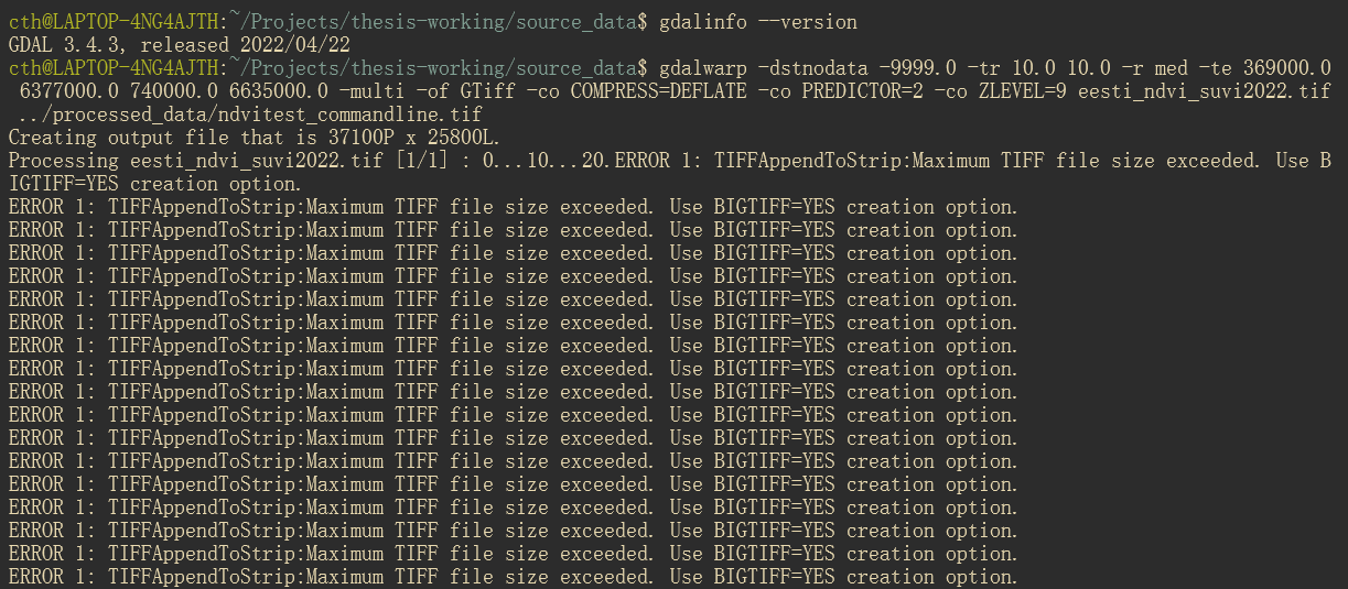
Raw command: gdalwarp -dstnodata -9999.0 -tr 10.0 10.0 -r med -te 369000.0 6377000.0 740000.0 6635000.0 -multi -of GTiff -co COMPRESS=DEFLATE -co PREDICTOR=2 -co ZLEVEL=9 eesti_ndvi_suvi2022.tif ../processed_data/ndvitest_commandline.tif
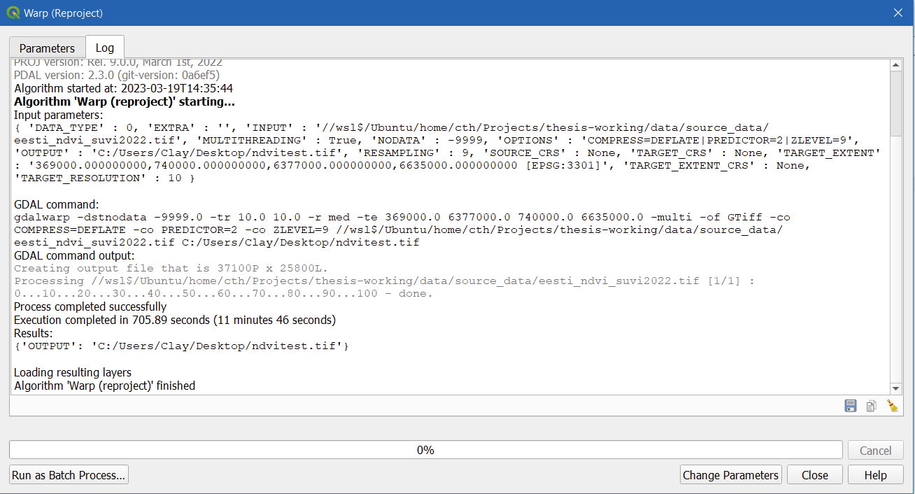
I built the command using the QGIS Warp tool, which you can see below:
Running the QGIS GDAL Warp tool works great! It does everything I need, and the result is even about ~2GB after compression. However, if I take the exact same command and run it in the command line, send it to the command line from Python, or use the Python GDAL bindings, the result is more like ~10GB and I have to turn on the BIGTIFF flag for it to even work:

The only difference at all is that I'm running my command line/Python in Linux (WSL2 Ubuntu) whereas my QGIS is running on Windows, so I've changed the I/O filepaths accordingly. Both are using GDAL 3.4.3.
For good measure, here's the GDALInfo on the input file:
Driver: GTiff/GeoTIFF
Files: eesti_ndvi_suvi2022.tif
Size is 37013, 24284
Coordinate System is:
PROJCRS["Estonian Coordinate System of 1997",
    BASEGEOGCRS["EST97",
        DATUM["Estonia 1997",
            ELLIPSOID["GRS 1980",6378137,298.257222101,
                LENGTHUNIT["metre",1]]],
        PRIMEM["Greenwich",0,
            ANGLEUNIT["degree",0.0174532925199433]],
        ID["EPSG",4180]],
    CONVERSION["Estonian National Grid",
        METHOD["Lambert Conic Conformal (2SP)",
            ID["EPSG",9802]],
        PARAMETER["Latitude of false origin",57.5175539305556,
            ANGLEUNIT["degree",0.0174532925199433],
            ID["EPSG",8821]],
        PARAMETER["Longitude of false origin",24,
            ANGLEUNIT["degree",0.0174532925199433],
            ID["EPSG",8822]],
        PARAMETER["Latitude of 1st standard parallel",59.3333333333333,
            ANGLEUNIT["degree",0.0174532925199433],
            ID["EPSG",8823]],
        PARAMETER["Latitude of 2nd standard parallel",58,
            ANGLEUNIT["degree",0.0174532925199433],
            ID["EPSG",8824]],
        PARAMETER["Easting at false origin",500000,
            LENGTHUNIT["metre",1],
            ID["EPSG",8826]],
        PARAMETER["Northing at false origin",6375000,
            LENGTHUNIT["metre",1],
            ID["EPSG",8827]]],
    CS[Cartesian,2],
        AXIS["northing (X)",north,
            ORDER[1],
            LENGTHUNIT["metre",1]],
        AXIS["easting (Y)",east,
            ORDER[2],
            LENGTHUNIT["metre",1]],
    USAGE[
        SCOPE["Topographic mapping (large scale)."],
        AREA["Estonia - onshore and offshore."],
        BBOX[57.52,20.37,60,28.2]],
    ID["EPSG",3301]]
Data axis to CRS axis mapping: 2,1
Origin = (369010.000000000000000,6620000.000000000000000)
Pixel Size = (10.000000000000000,-10.000000000000000)
Metadata:
  AREA_OR_POINT=Area
Image Structure Metadata:
  COMPRESSION=LZW
  INTERLEAVE=BAND
Corner Coordinates:
Upper Left  (  369010.000, 6620000.000) ( 21d40'24.68"E, 59d41'48.08"N)
Lower Left  (  369010.000, 6377160.000) ( 21d48'50.50"E, 57d31' 4.02"N)
Upper Right (  739140.000, 6620000.000) ( 28d14'36.00"E, 59d38'57.00"N)
Lower Right (  739140.000, 6377160.000) ( 27d59'15.00"E, 57d28'23.20"N)
Center      (  554075.000, 6498580.000) ( 24d55'50.87"E, 58d37'25.43"N)
Band 1 Block=37013x1 Type=Float32, ColorInterp=Gray
And on the (aborted) output file:
Driver: GTiff/GeoTIFF
Files: ndvitest_commandline.tif
Size is 37100, 25800
Coordinate System is:
PROJCRS["Estonian Coordinate System of 1997",
    BASEGEOGCRS["EST97",
        DATUM["Estonia 1997",
            ELLIPSOID["GRS 1980",6378137,298.257222101,
                LENGTHUNIT["metre",1]]],
        PRIMEM["Greenwich",0,
            ANGLEUNIT["degree",0.0174532925199433]],
        ID["EPSG",4180]],
    CONVERSION["Estonian National Grid",
        METHOD["Lambert Conic Conformal (2SP)",
            ID["EPSG",9802]],
        PARAMETER["Latitude of false origin",57.5175539305556,
            ANGLEUNIT["degree",0.0174532925199433],
            ID["EPSG",8821]],
        PARAMETER["Longitude of false origin",24,
            ANGLEUNIT["degree",0.0174532925199433],
            ID["EPSG",8822]],
        PARAMETER["Latitude of 1st standard parallel",59.3333333333333,
            ANGLEUNIT["degree",0.0174532925199433],
            ID["EPSG",8823]],
        PARAMETER["Latitude of 2nd standard parallel",58,
            ANGLEUNIT["degree",0.0174532925199433],
            ID["EPSG",8824]],
        PARAMETER["Easting at false origin",500000,
            LENGTHUNIT["metre",1],
            ID["EPSG",8826]],
        PARAMETER["Northing at false origin",6375000,
            LENGTHUNIT["metre",1],
            ID["EPSG",8827]]],
    CS[Cartesian,2],
        AXIS["northing (X)",north,
            ORDER[1],
            LENGTHUNIT["metre",1]],
        AXIS["easting (Y)",east,
            ORDER[2],
            LENGTHUNIT["metre",1]],
    USAGE[
        SCOPE["Topographic mapping (large scale)."],
        AREA["Estonia - onshore and offshore."],
        BBOX[57.52,20.37,60,28.2]],
    ID["EPSG",3301]]
Data axis to CRS axis mapping: 2,1
Origin = (369000.000000000000000,6635000.000000000000000)
Pixel Size = (10.000000000000000,-10.000000000000000)
Metadata:
  AREA_OR_POINT=Area
Image Structure Metadata:
  COMPRESSION=DEFLATE
  INTERLEAVE=BAND
  PREDICTOR=2
Corner Coordinates:
Upper Left  (  369000.000, 6635000.000) ( 21d39'50.66"E, 59d49'52.42"N)
Lower Left  (  369000.000, 6377000.000) ( 21d48'50.21"E, 57d30'58.84"N)
Upper Right (  740000.000, 6635000.000) ( 28d16'31.78"E, 59d46'58.91"N)
Lower Right (  740000.000, 6377000.000) ( 28d 0' 5.93"E, 57d28'16.39"N)
Center      (  554500.000, 6506000.000) ( 24d56'23.65"E, 58d41'25.04"N)
Band 1 Block=37100x1 Type=Float32, ColorInterp=Gray
  NoData Value=-9999
Anyone have any clue what's going on here?


gdalwarpto VRT thengdal_translateto final tif gis.stackexchange.com/a/89549/2856