1

I am merging some old maps with the georeferencer tool. but there are gaps on the edges of the old maps. These gaps can overlap the other map when merging the maps. As a solution I made the white parts of the maps transparent so that the maps can be merged without any problems. But since there are hundreds of maps, I want to merge the merged parts region by region into a single piece. I use the Raster Merge feature to merge the rasters into a single raster. But when I do this, it ignores the styles and the whites on the edges come back. As a result, there are gaps in my merged map. Is there a way to merge the raster layers without losing the styles?

Im using QGIS.

2
  • It exports in very low quality.
    – firstlord
    Commented Nov 28, 2023 at 20:17
  • Wow, an interesting alternative method. But it worked well. I changed the resolution to 3000dpi and it worked fine. Thank you so much!
    – firstlord
    Commented Nov 28, 2023 at 20:26

1 Answer 1

1

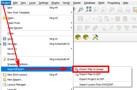
You can export the project/map canvas as image: go to menu Project > Import/Export > Export Map to Image.... Make appropriate settings for resolution of the output raster an be sure to check the box Append georeference information (embedded or via world file).

Maximal resolution seems to be 3000 dpi, but for most uses, this is large enough (if not much too large). If you need more details, you can zoom in and define the extent of a layer (e.g. an auxiliary polygon layer you create just for that purpose).

enter image description here

4
  • Is there any way to remove the 3000 dpi limit here?
    – firstlord
    Commented Nov 28, 2023 at 20:55
  • I want to export a certain extent at a time. But I will need a higher resolution. I read that I need to use print layout for this. I think I have done this before but I can't do it now. I try to export at a lower scale for the current extent. But when I specify the extent, the scale automatically changes according to the extent.
    – firstlord
    Commented Nov 28, 2023 at 21:12
  • Of course: scale, extent and resolution are connected, you can't change all three value independently. However: what resolution do your input rasters (georeferendced maps) have? It makes no sense to define a larger resolution than that. And: creating very large extent resluts in extremely large image files that are difficult to handle. So probably you should tell us a bit more about what you use this for to see what you need.
    – Babel
    Commented Nov 28, 2023 at 21:17
  • In the past, I needed to export a specific portion of a Google Satellite image in high resolution. I did this using print layout. I set a lower scale and a wider extent (yes, I was able to do this). The algorithm created a loop within the extent I specified, using the scale I specified. It exported all the images in one image. I will search this on google. Thank you very much for your help!
    – firstlord
    Commented Nov 28, 2023 at 21:27

Your Answer

By clicking “Post Your Answer”, you agree to our terms of service and acknowledge you have read our privacy policy.

Not the answer you're looking for? Browse other questions tagged or ask your own question.