2

I have a table of POIs which are simple Points I would like to know each time a POI is close to the polyline. I would like to get the number of meters from the start of the polyline each time a POI is close to it.

For example, I expect a result like this :

poi_id meters_from_start
1 123
1 1481
8 372

As you can see above the same POI can appear multiple times as the polyline can go multiple times near the POI, and in this case I would like to know at which meters from the start.

I tried this but I only get POIs close to the line but without the meters from start.

SELECT * FROM poi 
WHERE ST_Covers(ST_Buffer(ST_LineFromEncodedPolyline('the_polyline'), 0.0002), poi.location)

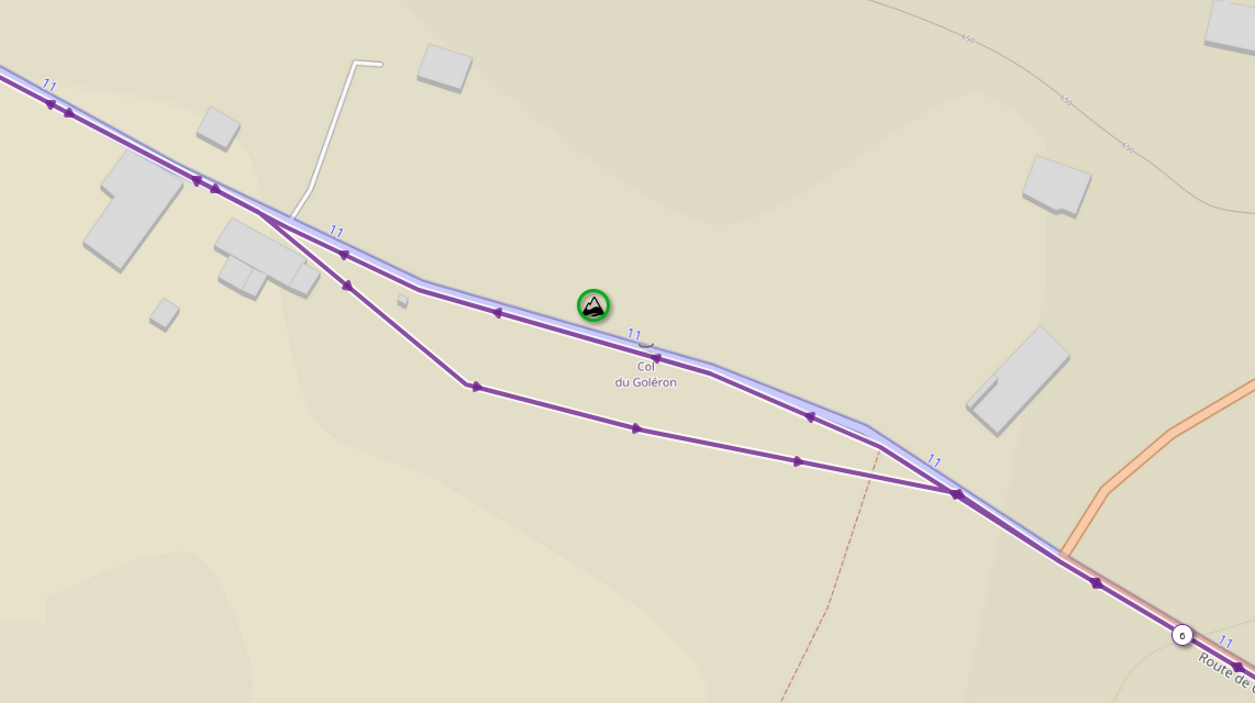
Here you can see an example polyline that get close to same POI 2 times : Image with polyline crossing two times close to the POI

2
  • ST_ClosestPoint example gis.stackexchange.com/a/207832/276
    – Mapperz
    Commented Sep 13 at 14:06
  • Ok, so with this I get the closest point representing my POI on polyline. I can get the distance from start of the polyline playing with ST_Substring and ST_LineLocatePoint. But if my polyline go through the POI and turn back and again pass through the POI, I woul like to have two references of my POI with attached distance from the start of the polyline.
    – ybert
    Commented Sep 13 at 14:39

1 Answer 1

3

That's a non-trivial thing to do without a broader set of trajectory analytics functionality at hand or in your own development.

However, a natural concept for this and similar, more specific linear reference tasks in SQL is to simulate trajectory traversal through segmentation and windowing:

SELECT
  id,
  distance_to_poi,
  -- this is where we sum up prior length and current partial lenght
  _cumulative_len + _partial_len AS distance_from_start,
  geom
FROM
  (
    SELECT
      -- pick whatever you need from the input tables
      p.id AS poi_id
      t.id AS trajectory_id,
      -- let's get the distance of this approach to the POI, too
      distance_to_poi,
      -- this is the fractional part of the current segment at which we are closest to the POI
      ST_Length(dmp.geom::GEOGRAPHY) * ST_LineLocatePoint(dmp.geom, p.geom) AS _partial_len,
      -- we will also need the cumulative length of all prior segments
      COALESCE(SUM(ST_Length(dmp.geom::GEOGRAPHY)) OVER(ORDER BY dmp.path ROWS BETWEEN UNBOUNDED PRECEDING AND 1 PRECEDING), 0.0) AS _cumulative_len,
      -- this is where we find out if the current segment is a closest approach
      (
        distance_to_poi <= ST_Distance(LAG(dmp.geom) OVER(ORDER BY dmp.path)::GEOGRAPHY, p.geom::GEOGRAPHY)
        AND
        distance_to_poi <= ST_Distance(LEAD(dmp.geom) OVER(ORDER BY dmp.path)::GEOGRAPHY, p.geom::GEOGRAPHY)
      ) AS _is_closest_approach,
      -- let's also get the actual location of this closest approach
      ST_LineInterpolatePoint(dmp.geom, location_frac) AS geom
    FROM
      <trajectory> AS t
      JOIN
      <poi> AS p ON
        <condition>
      CROSS JOIN LATERAL ST_DumpSegments(t.geom) AS dmp
      CROSS JOIN LATERAL ST_LineLocatePoint(dmp.geom, p.geom) AS location_frac
      CROSS JOIN LATERAL ST_Distance(dmp.geom::GEOGRAPHY, p.geom::GEOGRAPHY) AS distance_to_poi
  ) AS q
WHERE
  _is_closest_approach
  -- it may be a good idea to define a threshold distance until which you
  -- want to consider an approach to be close enough to count in your study
  AND
  distance_to_poi < <threshold>
;
1
  • 1
    That's a wicked query, works like a charm for OPs and my own purposes! Using the <threshold> is important for OPs case! Playing with the distance windows one can easily identify all parts of the trajectory closing in or moving away etc. - if you find some time, maybe you could elaborate a little more on the possibilities one has with this windowed traversal.
    – t.ry
    Commented Sep 17 at 7:00

Your Answer

By clicking “Post Your Answer”, you agree to our terms of service and acknowledge you have read our privacy policy.

Not the answer you're looking for? Browse other questions tagged or ask your own question.