3

I have a shapefile that represents counties (admin 2) only, but I need to create a state level (admin 1) polygon file (I'm using QGIS). I will need to sum up (or average) the relevant data at each district level as well.

There are far too many counties to do this manually, so does anyone know of an automated way to roll up to a higher administrative level like this?

I am new to QGIS.

3
  • Did you ever figure out how to do this? I am new to QGIS also and need to translate county data into district data.... Any help would be much appreciated. Thanks.
    – Zekia
    Commented Jan 4, 2018 at 19:10
  • This does not really answer the question. If you have a different question, you can ask it by clicking Ask Question. You can also add a bounty to draw more attention to this question once you have enough reputation. - From Review
    – aldo_tapia
    Commented Jan 4, 2018 at 19:38
  • Dissolve using county field
    – aldo_tapia
    Commented Jan 4, 2018 at 19:38

2 Answers 2

3

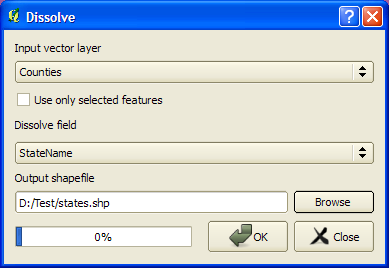
I suppose your county shapefile contains a field(like "StateName") that indicates which counties belong to which state. Then it should be a simple task.

  1. From menu use Vector -> Geoprocessing Tools -> Dissolve
  2. Select your state field as dissolve field.
  3. Now your counties would aggregate to give a new state level shapefile.

enter image description here

0

QGIS official repository has the Merge shapes plugin 0.1.19 available for use. There are a lot of math operations available using the QGIS 1.8.0 field calculator. Also, you could use Python for anything especially advanced or automated. I'd start by getting familiar with these, advancing toward Python as necessary to do what the simpler capabilities can't.

Your Answer

By clicking “Post Your Answer”, you agree to our terms of service and acknowledge you have read our privacy policy.

Not the answer you're looking for? Browse other questions tagged or ask your own question.