Can anyone suggest best Suitable Algorithm for Digital Elevation Model Generation? Currently I am working on Literature survey of DEM creation so i need to show comparison of 3-4 Algorithmic Methods used to create DEM & Best suitable method among them.
-
2Welcome to gis.SE. It would help if you can define "Suitable" and "Best", or at least some kind of metrics by which you intend to assess these algorithms. Also, what have you already looked at, and do not need additional details on? Also, can you provide a definition of "Algorithmic Methods" so we can include / exclude approaches based on your needs? Just edit your question (click edit above) to add these details.– BradHardsCommented May 18, 2013 at 14:30
1 Answer
There is no "best Suitable Algorithm" for what you want because it depends on the result you want to get
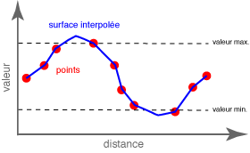
- You can choose a method whose resulting surface passes more or less exactly through the input points (TIN, Natural neighbour, Spline) -> "angular" surface

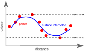
- you can choose a method that smoothens the surface according to various criteria (Inverse Distance Weighted, Trend, Kriging) -> surface not necessary passing through the input points :

Each method has its advantages and disadvantages depending on the result you are trying to reach.
So, select algorithms that match the needs of your project and whose strengths match the topography of your study area. Ideally, a different algorithm should be developed for each project area and having more than one available for use will allow for a comparison of results.
-
Ok. I have ENVI software which include above mentioned Interpolation Algorithms. For accurate DEM fusion can you suggest any software? or else how to create code in Matlab or other image processing softwares– SumitCommented Apr 23, 2014 at 7:07
