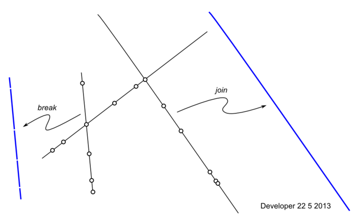
Referring to the Figure below:
- How to efficiently join segments into lines?
- How to efficiently break lines into segments?
The above will be applied million times.

You can use effectively Shapely, and Fiona to read a shapefile for example:
import fiona
# open a line shapefile
file = fiona.open('lines.shp')
# first element of the shapefile
first = file.next
print first
{'geometry': {'type': 'LineString', 'coordinates': [(203317.23, 90448.75), (203679.62, 90105.68), (203882.57, 89902.74), (204143.49, 89641.81), (204394.75, 89385.72), (204563.87, 89235.93)]}, 'id': '0', 'properties': {u'id': "1"}}
Now import Shapely
from shapely.geometry import Point, LineString, shape
geom = shape(first['geometry'])
# now it is a Shapely geometry
print geom
LINESTRING (203317.23 90448.75, 203679.62 90105.68, 203882.57 89902.74, 204143.49 89641.81, 204394.75 89385.72, 204563.87 89235.93)
Splitting
We can split the line in segments, each pair of coordinates (Point) define a line segment:
def pair(list):
    '''Iterate over pairs in a list -> pair of points '''
    for i in range(1, len(list)):
        yield list[i-1], list[i]

for seg_start, seg_end in pair(geom.coords):
    line_start = Point(seg_start)
    line_end = Point(seg_end)
    segment = LineString([line_start.coords[0],line_end.coords[0]])
    print segment
LINESTRING (203317.23 90448.75, 203679.62 90105.68)
LINESTRING (203679.62 90105.68, 203882.57 89902.74)
LINESTRING (203882.57 89902.74, 204143.49 89641.81)
LINESTRING (204143.49 89641.81, 204394.75 89385.72)
LINESTRING (204394.75 89385.72, 204563.87 89235.93)
You could do it directly with Fiona:
for seg_start, seg_end in paires(first['geometry']['coordinates']):
    ....
Union
If the line is straight, simply use the first and the last point to make the LineString
LINESTRING (203317.23 90448.75, 204563.87 89235.93)
In other cases, with shapely, you can use union, cascaded_union(geoms) or unary_union(geoms) and the result is a MULTILINESTRING;
With union:
line = LineString()
for element in line['geometry']['coordinates']:
   geom =shape(line['geometry'])
   profile = profile.union(geom)
print line
MULTILINESTRING ((203317.23 90448.75, 203679.62 90105.68), (203679.62 90105.68, 203882.57 89902.74), (203882.57 89902.74, 204143.49 89641.81), (204143.49 89641.81, 204394.756 89385.72), (204394.75 89385.72, 204563.87 89235.93))
or directly with shapely:
line = LineString()
for seg_start, seg_end in paires(geom.coords):
     line = line.union(LineString([Point(seg_start).coords[0],Point(seg_end).coords[0]]))
Intersection
The shapely function is geom1.intersection(geom2)
for two straight lines, it is simply
line1.intersection(line2) # the result is a Point
for two lines with segments, it is
(union of segments of line1).intersection(union of segments of line2) # the result is a Point or a MultiPoint (more than a single intersection)
And saving the results is easy with Fiona
It seems that Shapely can answer what you are expecting. See the manual. Create lines using native objects. For what you need, only loop ;) to get segments of a line. For getting intersection point, use operators like intersection
I can't say that is efficient but I suppose that because Shapely uses Geos behind, it's quite fast.
Shapely was 10 times slower than our mixed Python-Fortran implementation.
Commented
May 23, 2013 at 6:05
To join line segments you can assign a from-node# and a to-node# to each line segment, where the node# is a hash of x and y rounded off. For example, a point at 123.45,567.8 might be computed to be 123568. This implies a tolerance of 1. You could generalize this to round off to the closest multiple of the tolerance.
Once you have From and To node#'s, you can topologically sort the segments. This can be done by building a valence count for each node with a dictionary where the key is node# and the value is valence (the number of segments that share the node). Start at a node whose valence == 1 and walk until you reach another node whose valence==1, connecting the dots in other words. You can then use the topologically sorted list to build an ordered list of coordinates, i.e. a polyline.
Update: See whuber's similar question here.
Python using defaultdict. This is not efficient as you need to update the dictionary entirely after joining every two segments.
Commented
May 23, 2013 at 6:03
Python. The points above are intersection points with many other lines that are removed later. So our interest is to split each line to many segments based on the intersecting points (part left). Our another interest is reversing the act, that is having a series of aligned (parallel) segments to join them as one line if possible (part right).