1

I have a survey grid that spans 3 UTM zones. Using http://www.epsg-registry.org/ I can get an indication of what projections are available. Where can I find more info on the patterns of distortion within projections? And where can I find information on how I can modify the parameters of these projections (i.e. aspect and parallels)?

Ok So I gather the necessary information for a bounding box: i.e North Latitude, South Latitude, etc... EPSG Godetic Parameter Dataset screenshot
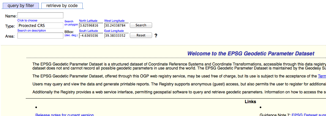
Let say that I then choose Africa Lambert Conformal Conic as my projection. If I then want to change the parallels of the projection using proj4 - how do I do it?

    +proj=lcc +lat_1=20 +lat_2=-23 +lat_0=0 +lon_0=25 +x_0=0 +y_0=0 +ellps=WGS84 +datum=WGS84 +units=m +no_defs

I would want to change this in order to bring the parallels closer to contain the survey grid i.e.:

    +proj=lcc +lat_1=5 +lat_2=-5 ?

Where can I find out if this is appropriate?

What do I need to consider with the rest of the proj4 string?

   +lon_0=25 etc?
1
  • bringing the parallels closer doesn't necessarily make the grid any more accurate. I just found this very helpful solution this week for creating low distortion projections. It is still in beta but allows you to visualize the distortion, and check residual/rms, then when you are happy you can download the prj and a georeferenced raster of the distortion levels. geo.ldpdesign.com
    – Brad Nesom
    Commented Jul 8, 2013 at 4:29

2 Answers 2

1

According to this source: http://www.georeference.org/doc/lambert_conformal_conic.htm

the lon_0 ant lat_0 should represent the center of the map.

5
  • thanks, I can use lon_0 and lat_0 to specify the center of the map, what about the option of setting the parallels? If lon_0=0 and lat_0=0 I should not have to specify further because I am dealing with data on the equator and I have no need for a transverse nor oblique projection. This does raise the question about the parallels again though - do I need to consider other transformations of latitude?
    – XNSTT
    Commented Jul 7, 2013 at 17:22
  • XNSTT, The Lambert conformal conic projection formulas break down when the two parallels are made equal and of opposite sign, as you propose to do. In this case it reaches its limiting value as a Mercator projection (see p. 18 of epsg.org/guides/docs/g7-2.pdf). Why not then just use a standard Mercator projection?
    – whuber
    Commented Jul 7, 2013 at 20:51
  • Please explain why you want an equidistant projection. Despite the name, such projections usually have relatively large metric distortion, because the distances are preserved only relative to one, two, or at most three special points. If--as I suspect--you are looking for a projection with very low distortion throughout, especially between the -5 and +5 parallels, then the Mercator is a decent choice: it's about as good as using the middle UTM zone :-). But there may be better solutions; for instance, a Stereographic centered in your area does a little better on average.
    – whuber
    Commented Jul 10, 2013 at 13:40
  • I am going to answer my question separately - but basically I was looking for something that was going to allow me to make measurements of distance in all directions without distortion - I assumed that a projection such as Equidistant Conic, with scale being constant on both meridians and parallels would allow me to do this - but I didn't know that means that distance is only true from the center radiating outwards (or from 2 or 3 points like you mention). Now I see my options are gnomonic or measuring in geographic distance
    – XNSTT
    Commented Jul 11, 2013 at 14:16
  • You have plenty more options than that :-). The choice depends partly on the shape of your study area. For instance, if it does not extend far in the north-south direction, a conic, polyconic, or oblique aspect of the Mercator will all be quite a bit better than anything you have mentioned.
    – whuber
    Commented Jul 11, 2013 at 19:50
0

The http://www.georeference.org/doc/lambert_conformal_conic.htm link mentioned above by Andre Joost and the following sites are good reference points to use to at least understand what spatial parameters can be manipulated within a given projection.

http://kartoweb.itc.nl/geometrics/Map%20projections/body.htm

http://www.mapthematics.com

The https://en.wikipedia.org/wiki/Map_projection site provides a nice overview of how to choose your projection based. In order to choose your projection you must first identify the most important single metric property (i.e. distance or area)that needs to be preserved. This will give you an indication of what class or 'surface' projection is optimal in terms of the preservation of this metric property based on the pattern of distortion that is caused by the projection. You must be aware of the effect of location on the classification in terms of how the aspect and origin of the projection will operate on your area of interest.

1
  • What I have not yet come across is a general quide of how to apply these options in the proj4 framework for each projection. This would be really useful!
    – XNSTT
    Commented Jul 11, 2013 at 14:36

Your Answer

By clicking “Post Your Answer”, you agree to our terms of service and acknowledge you have read our privacy policy.

Not the answer you're looking for? Browse other questions tagged or ask your own question.