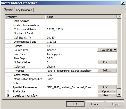
(This raster information for one of the clipped rasters)
I have a raster image representing a landscape that is about 1.3Gb. I clipped the raster into 31 sections which vary in size from 10Mb to 40Mb. Whenever I use the Fill tool on a section, the output raster is 1.3Gb (like the whole original raster). This is too much memory to process. Why is the Fill tool creating such a large output file for just a section of the original raster? Is there a way to reduce this size?
Edit: Additional Information
The Rasters were clipping using the methods in this previous question
Clip raster using shapefile into multiple rasters using ArcGIS Desktop?
Edit 2: Python Script changing the mask environment before using Fill (It works, but still provides the 1.3Gb "Fill" Raster)
import arcpy
from arcpy import env
from arcpy.sa import *
arcpy.env.workspace = (r"Workspace\Path")

    for i in range (31):

        arcpy.MakeFeatureLayer_management("shapefile","featurelayer" + str(i),'"FID"='+str(i))

        arcpy.env.mask = ("featurelayer"+str(i))

        arcpy.ClipManagement(“fullextentraster”, “#”, raster +“clip”+str(i)+ “.tif”, “file_name” + str(i), “0”, “ClippingGeometry”)

        outFill = Fill(“rasterclip”+str(i)+“.tif”)
        outFill.save (r“Save\Location\Folder\rasterfill”+str(i)+ “.tif”)
Edit 3: Python Script changing the processing extent environment before using Fill
import arcpy
from arcpy import env
from arcpy.sa import *
arcpy.env.workspace = (r"Workspace\Path")

    for i in range (31):

        arcpy.MakeFeatureLayer_management("shapefile","featurelayer" + str(i),'"FID"='+str(i))

        arcpy.env.extent= ("featurelayer"+str(i))

        arcpy.ClipManagement(“fullextentraster”, “#”, raster +“clip”+str(i)+ “.tif”, “file_name” + str(i), “0”, “ClippingGeometry”)

        outFill = Fill(“rasterclip”+str(i)+“.tif”)
        outFill.save (r“Save\Location\Folder\rasterfill”+str(i)+ “.tif”)

Filloperation using a mask (located in the environment settings) of your specific area of interest.