6

I have a polygon layer which I am drawing in ArcMap using a graduated color symbology:
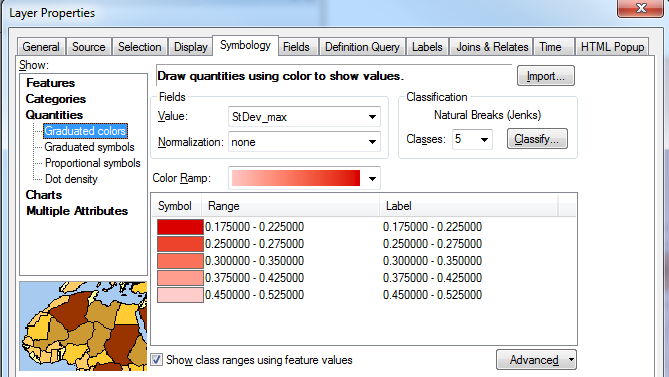
enter image description here

Is it possible to vary the transparency between the classes, so that the transparency tapers off with the color ramp?

For example, draw the first range (0.175 - 0.225) with no transparency, but the last range (0.45 - 0.52) with 50% transparency.

This is the effect I am trying to mimic, taken from Google Earth as a polygon KML:
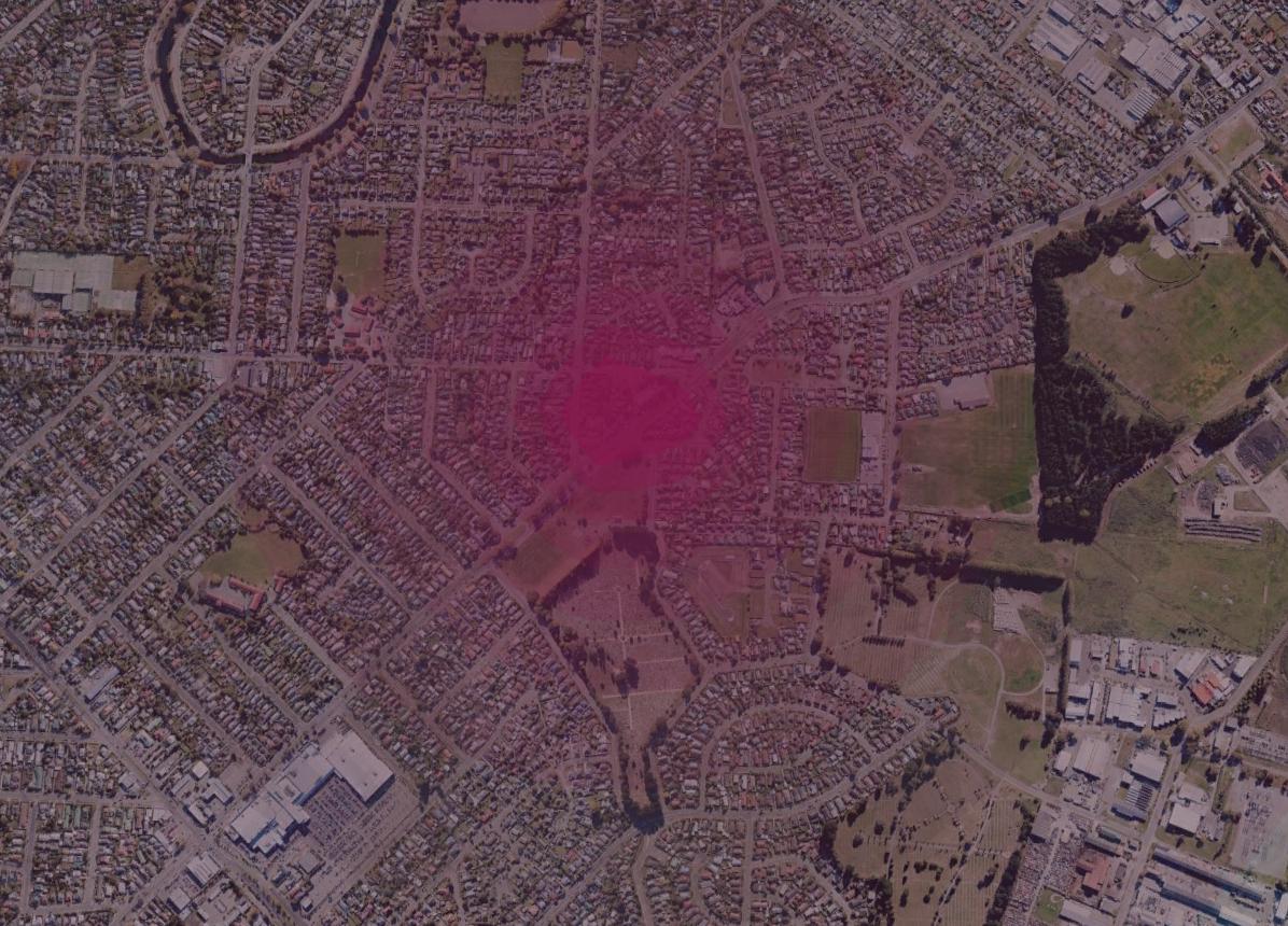
enter image description here

One workaround could be to create a separate layer for each class using a definition query, vary each layer's transparency, then group them together but I am looking for a less cumbersome approach.

5 Answers 5

8

The only way I know of to do this without creating many feature layers (one for each level of transparency) is to create a raster with an alpha channel.

Here is one possible workflow you can try:

  1. Use Polygon to Raster to convert your polygon features to a raster.
  2. Reclassify the data as desired (using 8-bit unsigned integer with values from 0-255 works best).
  3. Use Composite Bands to make a multi-band raster (can use the same input for multiple bands).
  4. Specify the band to use as an alpha channel:

    Rendering alpha bands

    An alpha band acts as a transparency mask, providing a transparency value for each pixel. An alpha band can be toggled on or off for multiple-band raster datasets rendered with the RGB Composite renderer.

    If you want to toggle the Alpha channel on or off, you will need to check the appropriate check box to turn it on or uncheck it to turn it off within the Symbology tab of the raster layer Properties dialog box.

    Steps:

    1. Right-click the raster layer you want to change the alpha band for in the table of contents and click Properties.
    2. Click the Symbology tab.
    3. Click RGB Composite.
    4. To turn the alpha band on, check the Alpha channel box and choose a band to use. To turn the alpha band off, uncheck the box for the Alpha channel.
    5. Click OK.

    Sources: 1 2

7

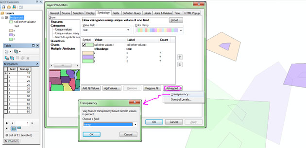
While looking into methods to answer one of your newer questions, I stumbled across a way to do exactly what you want with this one. (Taken from this ESRI forum post.)

  1. Add a short int field to your data that will hold transparency percentage values
  2. Select the records of each class and enter the desired percentages with the field calculator.
  3. On the Symbology tab, click the Advanced button (lower right), then select Transparency, and choose the field created to hold the values in the drop-down.

example of application

This functionality has been available since 8.1. As noted in that link, it only works on polygon fills. Also note that this feature allows you to control individual feature transparency, not just classes, as shown in the example above where I have symbolized on a class field but have given each feature varying transparency values even in the same class.

4

I know that your question is ArcGIS\ArcMap specific, but, maybe you are in the mood to try something different.

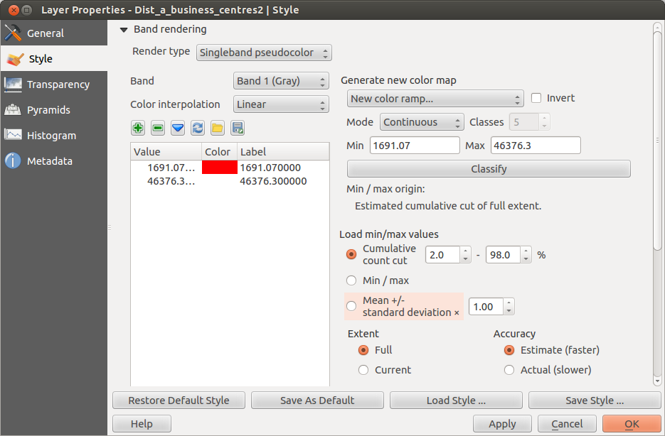
QGIS can do what you wan't. Style your layer with singleband pseudocolor.

enter image description here

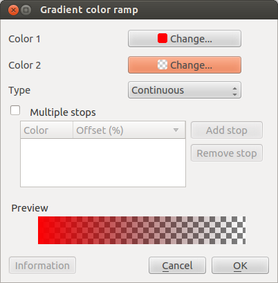
Create a new color ramp using gradient color.

enter image description here

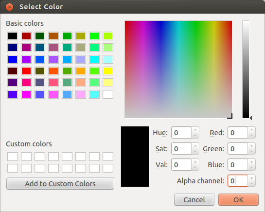
For one of the colors use 0 for the alpha chanel

enter image description here

And press classify.

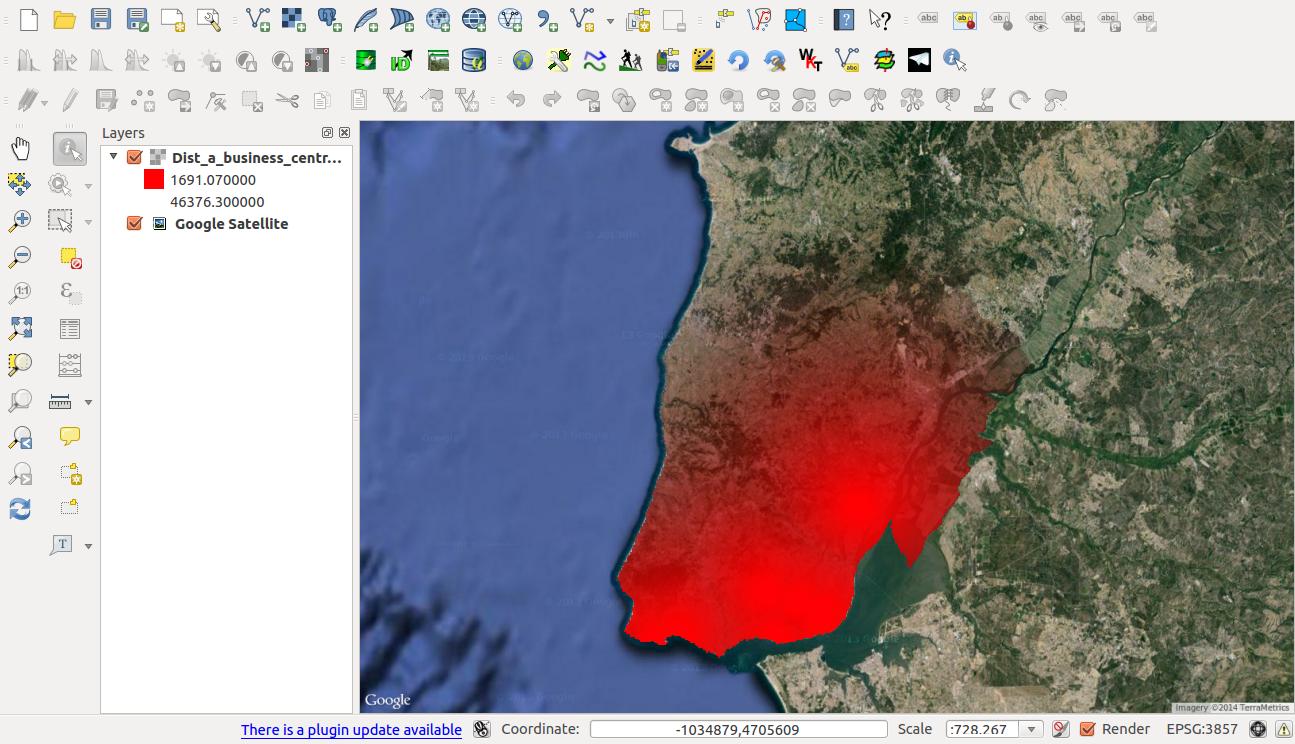
The result will be something like this:

enter image description here

Note that you can also set several intervals and set different alphas for each.

If you use multiply as layer blending mode you get a even nicer effect.

enter image description here

1
  • very nice, and thanks for the detailed write-up. It's funny when an open-source product can do something an expensive one can't... Unfortunately I need to use ArcGIS for this client project. Commented Apr 1, 2014 at 21:54
3

There is a workaround to do graduated transparency in the Esri Knowledge Base as a Technical Article entitled HowTo: Create graduated or proportional symbol transparency.

However, I have not tested it.

It dates from ArcGIS 8.3 and uses Convert Features to Graphics and Convert Graphics to Features (which was then only a Developer Sample). Even if it works, it looks to have a "cumbersome rating" akin to your workaround.

The long term solution might be to vote for an ArcGIS Idea called Symbology options and Transparency, and then again under ArcGIS Pro if the idea is not taken up by its release.

3
  • Have you used this before (I have not)? It doesn't sound to me like it actually varies the transparency of features individually, just enables layer-wide transparency for a couple of symbology types that did not support transparency at all.
    – blah238
    Commented Apr 1, 2014 at 3:15
  • @blah238 No - it came up in a search and my quick read made me think that it might work. Now I am not so sure and short on time to test so I will edit my Answer accordingly.
    – PolyGeo
    Commented Apr 1, 2014 at 3:21
  • I think @blah238 is right - this just allows you to make the whole layer transparent (which you can do anyway in ArcMap 10). PS I'd vote for that idea, except I can never get that stupid Ideas site to let me in ;) Commented Apr 1, 2014 at 3:42
0

There are several ways to get at this in ArcMap that all revolve around the same concept. If you only have 5 classes like you show in your question you can play with the individual color bins in at least two distinct ways.

  1. Make the lightest one “No Color” and grade up from there and setting a transparency. This is not much less cumbersome than the work around you propose though.
  2. Another slightly less cumbersome way is to use a Marker Fill for each symbol bin that uses the same color but reduces the density and/or size of dots in each Range. No transparency would be used for this option.

A third way, that doesn’t depend directly on the number of bins you have (though I’m guessing more is better up to a point; ten bins? twenty?), is to edit the properties of the Color Ramp itself (R-click, Properties…) to see if you can finesse the gradation to visually mimic what is shown in the Google Earth KML. Color Ramps can be easily set to grade into “No Color” from a highly saturated one.

[See EDIT below - color ramps don't (no longer?) work this way though they clearly should]

This last idea is the ArcGIS equivalent to what @Alexandre Neto proposes with QGIS.

[EDIT] Playing around with Dot-density fills based on a numeric value would likely be the best way to achieve this in ArcMap and not subsequently need to use a 3rd-party software.

2
  • Marker fill is a good alternative approach, but anything relying on 'no-color' won't work. For some reason in ArcGIS that doesn't equate to transparency in ramps, which is the core of this question. If you set one end to no color you still end up with white or some sort of gray. When you enable transparency on the layer, that white or gray still strongly affects the underlying layers. What's interesting is when you choose the no color option for a line or fill (not ramp or gradient), you don't see the feature. So is transparency working there, or does no color simply mean not drawn at all?
    – Chris W
    Commented Apr 30, 2014 at 23:56
  • @Chris W - You're right re ramps and transparencies. Guess that can be switched to symbolizing on "Quantities - Dot density". ESRI is so annoying like that. Which is why I always export a vector map with bit-fills and make a nice map using AI or other graphics software. Oh, and thanks for correcting me - maybe a previous version of ArcMap handled this like I was thinking?
    – user23715
    Commented May 2, 2014 at 19:04

Your Answer

By clicking “Post Your Answer”, you agree to our terms of service and acknowledge you have read our privacy policy.

Not the answer you're looking for? Browse other questions tagged or ask your own question.