1

I am calculating the hydropower potential of a large river basin. I have already had the hydrological modeling of the large (53000 km2) river basin and also I have DEM of the basin and river network. I am trying to calculate the cascade of hydropower potential along the river network. I want to start at any downstream point of a river (for hydropower station) and move upstream along the river in such a way that the head drop between the initially start point and final point would be greater than or equal to 10 m. When the head drop is more than or equal 10 m, I would like to move 1000 m upstream for next hydropower station assuming this as the second point for hydropower station. From this second start point I want to move upstream such that the head drop would be greater than or equal to 10 m. Likewise I would like to repeat along the whole river network till the end of river.

I could not work out it. Please help me how can I do it automatically and manually as well. As my river basin is very large (53000 square kilometer) , I want to do it automatically in ArcGIS.

1
  • 1
    assuming you know the value at the first hydro power station then you can do a contour with an interval of 10m and an offset of that value. This will give you stripes across the water every 10m above the first hydro power station. Commented Apr 13, 2014 at 8:11

1 Answer 1

1

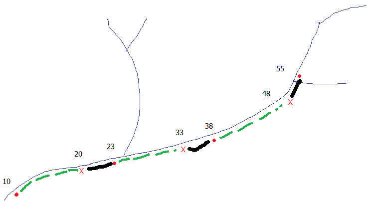
I just want clarify your question with the image below, is this what you meant? Example

  • Numbers are elevation in meters.
  • Red dots are the power stations
  • Red X is a location that fulfills your criteria of being at least 10m higher
  • Green dashed line is a distance which is initially unknown and is variable in length
  • Black line is exactly 1Km in length upstream of X which is the new proposed power station location

I think your first problem is defining a route to source because when you hit your first tributary which way do you go? One definition of a source is the furthest point upstream. So the first thing I would do is simplify your network by dropping all tributaries, you could do this manually or use RivEX which can encode the source ID into the vector network.

Dissolve the lines into a single polyline and create a polylineM featureclass this will allow you to locate and by creating linear events create the new hydro power station location. If you converted the underlying elevation pixels to points then snap them to the line you would be able to some sort of simple query of power station height + 10 to locate X.

At some point you are going to have to use Python or Arcobjects as I think model builder would be too slow or become stupidly complex to achieve this.

Interesting problem!

2
  • Yes it certainly is an interesting problem with no 'off the shelf' solution. I think the tricky part will be converting the rivers to polylines with M. There is a centreline function but it doesn't work so well with rivers, would (could) you use the polygon boundaries - this would give two answers: one left one right or do you know of a simple way to collapse riverine polygons to a centreline automatically? Commented Apr 13, 2014 at 23:15
  • Sorry, forgot to link to the centreline tool, it's called 'Collapse Dual Lines To Centerline', find it here help.arcgis.com/en/arcgisdesktop/10.0/help/index.html#//…. It works well on regular width polygons like street casements and helps with irregular width polygons but a lot of manual fixing is requred. Commented Apr 13, 2014 at 23:41

Your Answer

By clicking “Post Your Answer”, you agree to our terms of service and acknowledge you have read our privacy policy.

Not the answer you're looking for? Browse other questions tagged or ask your own question.