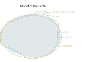
The term horizontal datum is used because it is more easily flattened into 2 dimensions and more useful for finding locations on a flat plane (compared to a vertical datum).
The "ellipsoid" used in horizontal datums is somewhat arbitrary representation of the Earths surface. As in the ESRI post you referenced (image below), the Earth's surface is very uneven, so modeling this very difficult. While you can use a horizontal datum to determine height simply because it is a 3D model, it is not as useful as a geoid (used in vertical datums) which has some "physical" meaning because it is based on mean sea surface heights which can be estimated relatively easily and accurately. Therefore, heights are better represented or estimated with a geoid because they represent a physical estimate of mean sea level.

