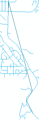
Here is the problem I am facing. After geocoding some addresses, I used the "point to line" tool. Some long streets with minimal matching address points created long lines that intersect the road layer. What I need is for the dark blue line to "snap" as close as possible to the light blue road layer.
What I've tried: Densifying the dark blue line and then edge-snapping to the roads layer. The line then snaps to the wrong road sometimes. The vertices of the dark blue line are the points that matched to the light blue line.
Is there anyway I can give the "points to line" result the same street name and then snap to the matching street?
Using ArcMap Desktop Advanced 10.2.

