5

I have ArcGIS 10.1 and am working on a project involving extraction of vegetation and building classes from LIDAR (unclassified) data and aerial imagery (resolution 30x30cm).

I have managed to extract each class after following many LIDAR processing and Spatial Analysis steps; however, I could not find an automated way of correcting building footprints according to possible orthogonal boundaries. I have applied Simplify algorithms (in Cartography toolbox) in ArcGIS 10.1 and the best result as far as I can get is given in the first image. My question is:

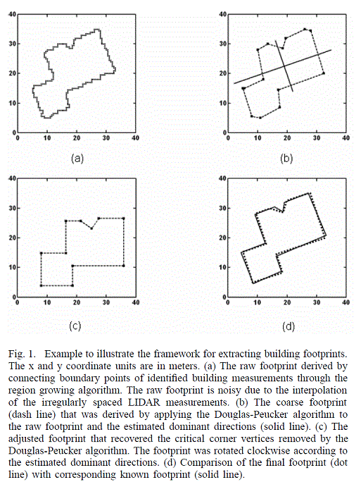
Is there any free/open source library/script (preferably in Python) to correct polygon edges to (almost) true building boundaries? More specifically, I am looking for a method similar to the one given in the second image below:
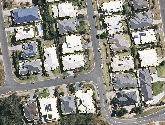
Resulting building footprint

enter image description here

from Zhang etal (2006). Automatic Construction of Building Footprints from Airborne LIDAR Data.

5
  • Zhang may be credited with this but I can remember Michael Knight (at FUGRO at the time) was using this method in Microstation before then (2002-3).. try using Simplify Buildings or Aggregate Polygons. Commented Jun 19, 2015 at 5:33
  • 1
    Thanks @MichaelMiles-Stimson, in fact this is the best result that I got after Simplify feature tool varities and Aggregate Polygons seems irrelevant here. The result is (process-wise) pretty similar to the step (b) of Zhang/Knight methodology.
    – fatih_dur
    Commented Jun 19, 2015 at 5:56
  • 1
    @fatih_dur I think that you should extract your UPDATE about ArcGIS Pro and post it as a self-answer instead.
    – PolyGeo
    Commented Jan 17, 2017 at 6:45
  • Can you describe at all your process on how you collected the building footprints either here or somewhere else. I am very interested in extracting building footprints from lidar.
    – Malcolm
    Commented Jan 5, 2018 at 16:48
  • @malcolm the method I used is not different than what you can find in the Internet, find vegetation via LIDAR and NDVI(or other indices), remove those from overall above-ground features coming from LIDAR and optionally check those building patches with aerial imagery to at least correctly extract lighter rooftop. At one stage I remember looking at the average rate and variety of height change to make sure I am dealing with consistently changing features, presuming tree branches portray almost a random picture.
    – fatih_dur
    Commented Jan 7, 2018 at 23:47

1 Answer 1

3

In ArcGIS Pro, there is a new tool within 3D Analyst toolset called Regularize Building Footprint, which looks like what I want to achieve but this is not available in ArcGIS Desktop.

Your Answer

By clicking “Post Your Answer”, you agree to our terms of service and acknowledge you have read our privacy policy.

Not the answer you're looking for? Browse other questions tagged or ask your own question.