Bumped by Community user
Post Reopened by PolyGeo
edited tags
Link
PolyGeo
  • 65.4k
  • 29
  • 114
  • 345
Secondary questions removed.
Source Link

Pre-processing Converting Worldview 2 imagery to TOA reflectance for Vegetation Change detection in ArcGIS or Qgis?

I am working on a change detection study to look at effects of herbicides on vegetation growth. Therefore I have Worldview 2 (4 band +pan band) imagery for two subsequent years that I would like to use for a change detection analysis, but need some advice on appropriate pre-processing steps.

My proposed techniques to evaluate the change is first is a simple comparison of NDVI between the two years and secondly to run a Random Forest Classification in R. I have been trying to follow the guidance outlined in the Digital Globe Radiometric Use of Worldview 2 Imagery document, but am having a bit of trouble deciphering exactly what formulas I need to use to make my imagery comparable between years.

Initially, my workflow was to:

  1. Convert to DN to Top-of-Atmosphere Spectral Radiance using the second formula from section 5.1 of the document (see equation 1 below) using ArcGIS raster calculator.

  2. Convert results from step 1 to Top of Atmosphere band-average reflectance using the last equation from section 7 of the technical document (see equation 2 below) using ArcGIS raster calculator.

  3. Run the NDVI and R forest classification using the appropriate Top of Atmosphere band-average reflectance layers.

From this step I could then run the NDVI and R forest classification using the appropriate Top of Atmosphere band-average reflectance layers.

However, after re-reviewing the Digital Globe technical document, I am wondering if I also need to complete the radiometric balancing for multiple scenes outlined in Section 6 (See equations 3 or 4 below):

My question or is whether this radiometric balancing step is required or if this already accounted for in the formula for converting to Top of Atmosphere band-average reflectance (Equation 2)? If so, what further processing is required prior to calculating NDVI?

As an FYI I have access/knowledge of both ArcGIS and Q-gis for this analysis.

Equations From Technical Document Proposed:

enter link description here

Pre-processing Worldview 2 imagery for Vegetation Change detection in ArcGIS or Qgis?

I am working on a change detection study to look at effects of herbicides on vegetation growth. Therefore I have Worldview 2 (4 band +pan band) imagery for two subsequent years that I would like to use for a change detection analysis, but need some advice on appropriate pre-processing steps.

My proposed techniques to evaluate the change is first is a simple comparison of NDVI between the two years and secondly to run a Random Forest Classification in R. I have been trying to follow the guidance outlined in the Digital Globe Radiometric Use of Worldview 2 Imagery document, but am having a bit of trouble deciphering exactly what formulas I need to use to make my imagery comparable between years.

Initially, my workflow was to:

  1. Convert to DN to Top-of-Atmosphere Spectral Radiance using the second formula from section 5.1 of the document (see equation 1 below).

  2. Convert results from step 1 to Top of Atmosphere band-average reflectance using the last equation from section 7 of the technical document (see equation 2 below).

From this step I could then run the NDVI and R forest classification using the appropriate Top of Atmosphere band-average reflectance layers.

However, after re-reviewing the Digital Globe technical document, I am wondering if I also need to complete the radiometric balancing for multiple scenes outlined in Section 6 (See equations 3 or 4 below):

My question is whether this radiometric balancing step is required or if this already accounted for in the formula for converting to Top of Atmosphere band-average reflectance (Equation 2)? If so, what further processing is required prior to calculating NDVI?

As an FYI I have access/knowledge of both ArcGIS and Q-gis for this analysis.

Equations From Technical Document Proposed:
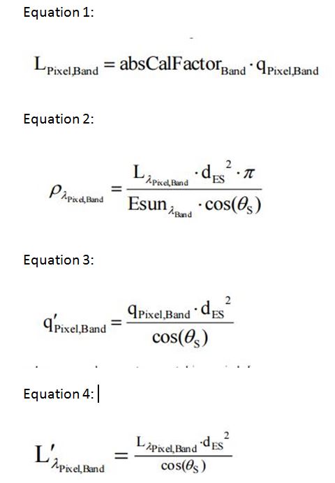
enter link description here

Converting Worldview 2 imagery to TOA reflectance for Vegetation Change detection in ArcGIS?

I am working on a change detection study to look at effects of herbicides on vegetation growth. Therefore I have Worldview 2 (4 band +pan band) imagery for two subsequent years that I would like to use for a change detection analysis, but need some advice on appropriate pre-processing steps.

My proposed techniques to evaluate the change is first is a simple comparison of NDVI between the two years and secondly to run a Random Forest Classification in R. I have been trying to follow the guidance outlined in the Digital Globe Radiometric Use of Worldview 2 Imagery document, but am having a bit of trouble deciphering exactly what formulas I need to use to make my imagery comparable between years.

Initially, my workflow was to:

  1. Convert to DN to Top-of-Atmosphere Spectral Radiance using the second formula from section 5.1 of the document (see equation 1 below) using ArcGIS raster calculator.

  2. Convert results from step 1 to Top of Atmosphere band-average reflectance using the last equation from section 7 of the technical document (see equation 2 below) using ArcGIS raster calculator.

  3. Run the NDVI and R forest classification using the appropriate Top of Atmosphere band-average reflectance layers.

However, after re-reviewing the Digital Globe technical document, I am wondering if I also need to complete the radiometric balancing for multiple scenes outlined in Section 6 (See equations 3 or 4 below) or is step already accounted for in the formula for converting to Top of Atmosphere band-average reflectance (Equation 2)?

Equations From Technical Document Proposed:

enter link description here

Secondary questions removed.
Source Link

I am working on a change detection study to look at effects of herbicides on vegetation growth. Therefore I have Worldview 2 (4 band +pan band) imagery for two subsequent years that I would like to use for a change detection analysis, but need some advice on appropriate pre-processing steps.

My proposed techniques to evaluate the change is first is a simple comparison of NDVI between the two years and secondly to run a Random Forest Classification in R. I have been trying to follow the guidance outlined in the Digital Globe Radiometric Use of Worldview 2 Imagery document, but am having a bit of trouble deciphering exactly what formulas I need to use to make my imagery comparable between years.

Initially, my workflow was to:

  1. Convert to DN to Top-of-Atmosphere Spectral Radiance using the second formula from section 5.1 of the document (see equation 1 below).

  2. Convert results from step 1 to Top of Atmosphere band-average reflectance using the last equation from section 7 of the technical document (see equation 2 below).

From this step I could then run the NDVI and R forest classification using the appropriate Top of Atmosphere band-average reflectance layers.

However, after re-reviewing the Digital Globe technical document, I am wondering if I also need to complete the radiometric balancing for multiple scenes outlined in Section 6 (See equations 3 or 4 below):

OrMy question is whether this radiometric balancing step is required or if this already accounted for in the formula for converting to Top of Atmosphere band-average reflectance (Equation 2)?

Both of my scenes look vastly different when viewed in 3,2,1 or 4,3,2 band combinations If so I suspect some sort of, what further processing to remove atmospheric effect and match the images. I was originally thinking a dark area subtraction for each image by just subtracting each band by its lowest pixel value prior to converting to radiance and reflectance, but not sure that is correct way to do it? I am a bit concerned there are no deep dark lakes in the images though so not sure this is the best technique as its likely dark pixels are simply shadows. Any thoughts?

My other question is whether I should be pan-sharpening before or after converting to TOA reflectance? Should the pan ban also be convertedrequired prior to TOA reflectancecalculating NDVI?

As an FYI I have access/knowledge of both ArcGIS and Q-gis for this analysis.

Equations From Technical Document Proposed:

enter link description here

I am working on a change detection study to look at effects of herbicides on vegetation growth. Therefore I have Worldview 2 (4 band +pan band) imagery for two subsequent years that I would like to use for a change detection analysis, but need some advice on appropriate pre-processing steps.

My proposed techniques to evaluate the change is first is a simple comparison of NDVI between the two years and secondly to run a Random Forest Classification in R. I have been trying to follow the guidance outlined in the Digital Globe Radiometric Use of Worldview 2 Imagery document, but am having a bit of trouble deciphering exactly what formulas I need to use to make my imagery comparable between years.

Initially, my workflow was to:

  1. Convert to DN to Top-of-Atmosphere Spectral Radiance using the second formula from section 5.1 of the document (see equation 1 below).

  2. Convert results from step 1 to Top of Atmosphere band-average reflectance using the last equation from section 7 of the technical document (see equation 2 below).

From this step I could then run the NDVI and R forest classification using the appropriate Top of Atmosphere band-average reflectance layers.

However, after re-reviewing the Digital Globe technical document, I am wondering if I also need to complete the radiometric balancing for multiple scenes outlined in Section 6 (See equations 3 or 4 below):

Or is this already accounted for in the formula for converting to Top of Atmosphere band-average reflectance?

Both of my scenes look vastly different when viewed in 3,2,1 or 4,3,2 band combinations so I suspect some sort of further processing to remove atmospheric effect and match the images. I was originally thinking a dark area subtraction for each image by just subtracting each band by its lowest pixel value prior to converting to radiance and reflectance, but not sure that is correct way to do it? I am a bit concerned there are no deep dark lakes in the images though so not sure this is the best technique as its likely dark pixels are simply shadows. Any thoughts?

My other question is whether I should be pan-sharpening before or after converting to TOA reflectance? Should the pan ban also be converted to TOA reflectance?

As an FYI I have access/knowledge of both ArcGIS and Q-gis for this analysis.

Equations From Technical Document Proposed:

enter link description here

I am working on a change detection study to look at effects of herbicides on vegetation growth. Therefore I have Worldview 2 (4 band +pan band) imagery for two subsequent years that I would like to use for a change detection analysis, but need some advice on appropriate pre-processing steps.

My proposed techniques to evaluate the change is first is a simple comparison of NDVI between the two years and secondly to run a Random Forest Classification in R. I have been trying to follow the guidance outlined in the Digital Globe Radiometric Use of Worldview 2 Imagery document, but am having a bit of trouble deciphering exactly what formulas I need to use to make my imagery comparable between years.

Initially, my workflow was to:

  1. Convert to DN to Top-of-Atmosphere Spectral Radiance using the second formula from section 5.1 of the document (see equation 1 below).

  2. Convert results from step 1 to Top of Atmosphere band-average reflectance using the last equation from section 7 of the technical document (see equation 2 below).

From this step I could then run the NDVI and R forest classification using the appropriate Top of Atmosphere band-average reflectance layers.

However, after re-reviewing the Digital Globe technical document, I am wondering if I also need to complete the radiometric balancing for multiple scenes outlined in Section 6 (See equations 3 or 4 below):

My question is whether this radiometric balancing step is required or if this already accounted for in the formula for converting to Top of Atmosphere band-average reflectance (Equation 2)? If so, what further processing is required prior to calculating NDVI?

As an FYI I have access/knowledge of both ArcGIS and Q-gis for this analysis.

Equations From Technical Document Proposed:

enter link description here

deleted 96 characters in body
Source Link
PolyGeo
  • 65.4k
  • 29
  • 114
  • 345
Loading
Post Closed as "Needs more focus" by PolyGeo
Source Link
Loading