Post Reopened by PolyGeo
deleted 40 characters in body
Source Link
PolyGeo
  • 65.4k
  • 29
  • 114
  • 345

I have a point layer of known landslide locations, and a raster layer (30m) of vegetation cover (categorical). My goal is to extract the prevailing raster value around the point locations.

Here is the problem:

Almost all landslides are located within 30m of a road which means that if I use the "extract value to point' tool, my out put would only correspond to the raster class "Developed-Roads". This is not helpful since I need to look at cells further away from the road in order to obtain "true" vegetation values like "Tree Cover >= 70 and < 80%", for instance. I can't create buffers around the point locations and run zonal statistics, because there is too much overlap.

When I researched this problem, I also came across the "focal statistics" tool, but I don't see how that is helpful. Even though the tool allows you to define various neighborhoods that would certainly be an advantage, it doesn't allow me to input a point feature and a raster layer at the same time.

Question: Can I use focal statistics, if so how? If not, what other options are there?

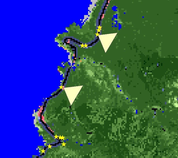
Check out the picture to get a better idea of the problem:   

enter image description here

I have a point layer of known landslide locations, and a raster layer (30m) of vegetation cover (categorical). My goal is to extract the prevailing raster value around the point locations.

Here is the problem:

Almost all landslides are located within 30m of a road which means that if I use the "extract value to point' tool, my out put would only correspond to the raster class "Developed-Roads". This is not helpful since I need to look at cells further away from the road in order to obtain "true" vegetation values like "Tree Cover >= 70 and < 80%", for instance. I can't create buffers around the point locations and run zonal statistics, because there is too much overlap.

When I researched this problem, I also came across the "focal statistics" tool, but I don't see how that is helpful. Even though the tool allows you to define various neighborhoods that would certainly be an advantage, it doesn't allow me to input a point feature and a raster layer at the same time.

Question: Can I use focal statistics, if so how? If not, what other options are there?

Check out the picture to get a better idea of the problem:  enter image description here
I have a point layer of known landslide locations, and a raster layer (30m) of vegetation cover (categorical). My goal is to extract the prevailing raster value around the point locations.

Almost all landslides are located within 30m of a road which means that if I use the "extract value to point' tool, my out put would only correspond to the raster class "Developed-Roads". This is not helpful since I need to look at cells further away from the road in order to obtain "true" vegetation values like "Tree Cover >= 70 and < 80%", for instance. I can't create buffers around the point locations and run zonal statistics, because there is too much overlap.

When I researched this problem, I also came across the "focal statistics" tool, but I don't see how that is helpful. Even though the tool allows you to define various neighborhoods that would certainly be an advantage, it doesn't allow me to input a point feature and a raster layer at the same time.

Can I use focal statistics, if so how? If not, what other options are there?

Check out the picture to get a better idea of the problem: 

enter image description here

deleted 607 characters in body
Source Link
DanM
  • 75
  • 6

I have a point layer of known landslide locations, and a raster layer (30m) of vegetation cover (categorical). My goal is to extract the prevailing raster value around the point locations.

Here is the problem:

Almost all landslides are located within 30m of a road which means that if I use the "extract value to point' tool, my out put would only correspond to the raster class "Developed-Roads". This is not helpful since I need to look at cells further away from the road in order to obtain "true" vegetation values like "Tree Cover >= 70 and < 80%", for instance. I can't create buffers around the point locations and run zonal statistics, because there is too much overlap.

When I researched this problem, I also came across the "focal statistics" tool, but I don't see how that is helpful. Even though the tool allows you to define various neighborhoods that would certainly be an advantage, it doesn't allow me to input a point feature and a raster layer at the same time.

Question 1: Can I use focal statistics, if so how? If not, what other options are there?

Since many of these landslides occurred along Highway 101 (running north to south) it is not very appropriate to apply a round kernel. The west side of the highway corresponds to water and the east side to some vegetation class. Therefore, if I applied a circle, square, etc. and took the majority of cell values to assign it to my points, it would most likely end up being water. Ideally, I would need a wedge kernel that adjusts in the direction of higher elevation.

Question 2: Are there dynamic wedge kernels that adjust their direction based on some attribute?

Check out the picture to get a better idea of the problem: enter image description here

Any suggestions or thoughts?

I have a point layer of known landslide locations, and a raster layer (30m) of vegetation cover (categorical). My goal is to extract the prevailing raster value around the point locations.

Here is the problem:

Almost all landslides are located within 30m of a road which means that if I use the "extract value to point' tool, my out put would only correspond to the raster class "Developed-Roads". This is not helpful since I need to look at cells further away from the road in order to obtain "true" vegetation values like "Tree Cover >= 70 and < 80%", for instance. I can't create buffers around the point locations and run zonal statistics, because there is too much overlap.

When I researched this problem, I also came across the "focal statistics" tool, but I don't see how that is helpful. Even though the tool allows you to define various neighborhoods that would certainly be an advantage, it doesn't allow me to input a point feature and a raster layer at the same time.

Question: Can I use focal statistics, if so how? If not, what other options are there?

Check out the picture to get a better idea of the problem: enter image description here

Post Closed as "Needs more focus" by PolyGeo
edited tags
Link
PolyGeo
  • 65.4k
  • 29
  • 114
  • 345
Source Link
DanM
  • 75
  • 6
Loading