added 94 characters in body
Source Link
David
  • 393
  • 4
  • 12

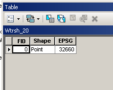
I have many point shapefiles all in WGS84 and I need to project them to different Coordinate systems. Every shapefile has only one point with its coordinates and the EPSG number for which the point is to be projected to.

Example Shapefile Attribute Table

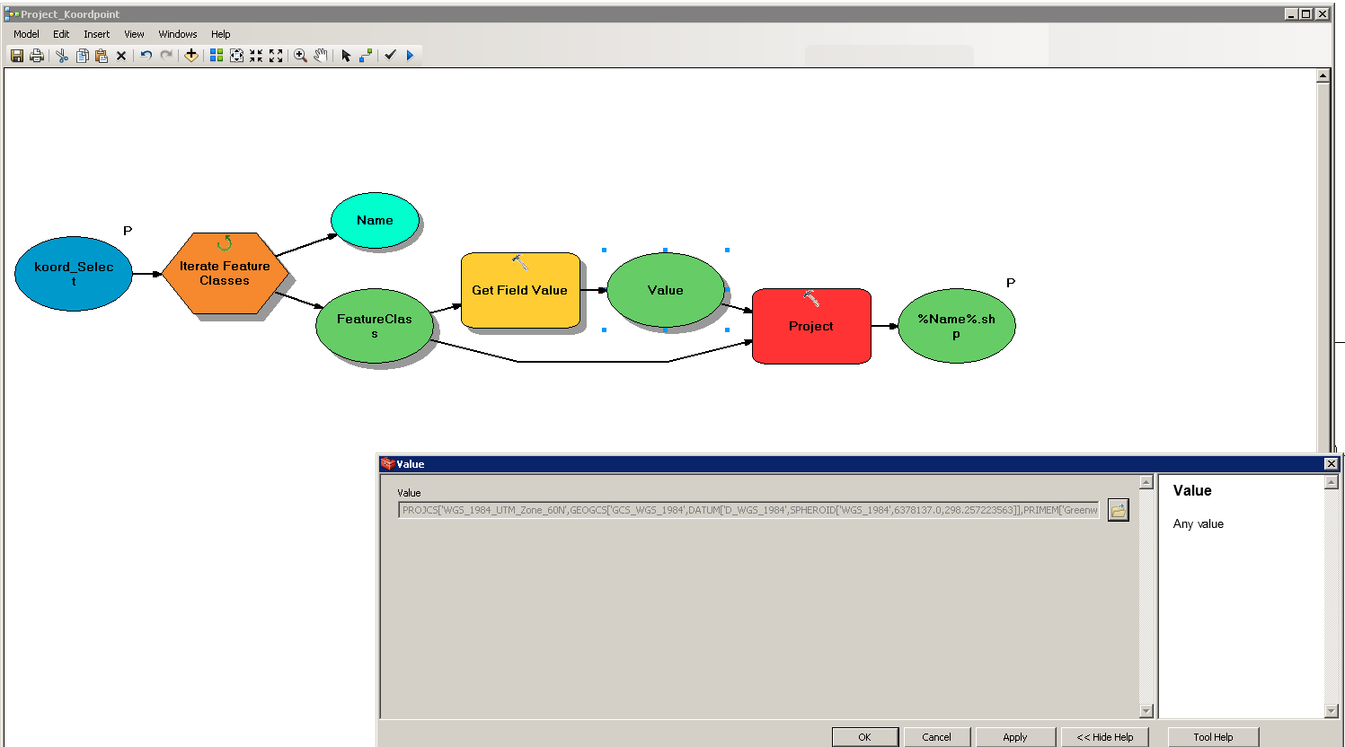
So I've created a little Iteration in the ModelBuilder.

enter image description here

The Value is stored as "Coordinate System". But unfortunately I get the following error at the projection part.

Executing (Project): Project D:\David\Verarbeitete_Daten\Preprocessing\koord_Select\Wtrsh_9.shp D:\David\Verarbeitete_Daten\Preprocessing\Koord_proj\Wtrsh_9.shp PROJCS['WGS_1984_UTM_Zone_60N',GEOGCS['GCS_WGS_1984',DATUM['D_WGS_1984',SPHEROID['WGS_1984',6378137.0,298.257223563]],PRIMEM['Greenwich',0.0],UNIT['Degree',0.0174532925199433]],PROJECTION['Transverse_Mercator'],PARAMETER['False_Easting',500000.0],PARAMETER['False_Northing',0.0],PARAMETER['Central_Meridian',177.0],PARAMETER['Scale_Factor',0.9996],PARAMETER['Latitude_Of_Origin',0.0],UNIT['Meter',1.0]] # GEOGCS['GCS_WGS_1984',DATUM['D_WGS_1984',SPHEROID['WGS_1984',6378137.0,298.257223563]],PRIMEM['Greenwich',0.0],UNIT['Degree',0.0174532925199433]] NO_PRESERVE_SHAPE # NO_VERTICAL
Start Time: Wed Apr 18 11:53:55 2018
ERROR 999999: Error executing function.
invalid extent for output coordinate system
Failed to execute (Project).
Failed at Wed Apr 18 11:53:55 2018 (Elapsed Time: 0.01 seconds)

What is the reason for that?

I have many point shapefiles all in WGS84 and I need to project them to different Coordinate systems. Every shapefile has only one point with its coordinates and the EPSG number for which the point is to be projected to.

So I've created a little Iteration in the ModelBuilder.

enter image description here

The Value is stored as "Coordinate System". But unfortunately I get the following error at the projection part.

Executing (Project): Project D:\David\Verarbeitete_Daten\Preprocessing\koord_Select\Wtrsh_9.shp D:\David\Verarbeitete_Daten\Preprocessing\Koord_proj\Wtrsh_9.shp PROJCS['WGS_1984_UTM_Zone_60N',GEOGCS['GCS_WGS_1984',DATUM['D_WGS_1984',SPHEROID['WGS_1984',6378137.0,298.257223563]],PRIMEM['Greenwich',0.0],UNIT['Degree',0.0174532925199433]],PROJECTION['Transverse_Mercator'],PARAMETER['False_Easting',500000.0],PARAMETER['False_Northing',0.0],PARAMETER['Central_Meridian',177.0],PARAMETER['Scale_Factor',0.9996],PARAMETER['Latitude_Of_Origin',0.0],UNIT['Meter',1.0]] # GEOGCS['GCS_WGS_1984',DATUM['D_WGS_1984',SPHEROID['WGS_1984',6378137.0,298.257223563]],PRIMEM['Greenwich',0.0],UNIT['Degree',0.0174532925199433]] NO_PRESERVE_SHAPE # NO_VERTICAL
Start Time: Wed Apr 18 11:53:55 2018
ERROR 999999: Error executing function.
invalid extent for output coordinate system
Failed to execute (Project).
Failed at Wed Apr 18 11:53:55 2018 (Elapsed Time: 0.01 seconds)

What is the reason for that?
I have many point shapefiles all in WGS84 and I need to project them to different Coordinate systems. Every shapefile has only one point with its coordinates and the EPSG number for which the point is to be projected to.

Example Shapefile Attribute Table

So I've created a little Iteration in the ModelBuilder.

enter image description here

The Value is stored as "Coordinate System". But unfortunately I get the following error at the projection part.

Executing (Project): Project D:\David\Verarbeitete_Daten\Preprocessing\koord_Select\Wtrsh_9.shp D:\David\Verarbeitete_Daten\Preprocessing\Koord_proj\Wtrsh_9.shp PROJCS['WGS_1984_UTM_Zone_60N',GEOGCS['GCS_WGS_1984',DATUM['D_WGS_1984',SPHEROID['WGS_1984',6378137.0,298.257223563]],PRIMEM['Greenwich',0.0],UNIT['Degree',0.0174532925199433]],PROJECTION['Transverse_Mercator'],PARAMETER['False_Easting',500000.0],PARAMETER['False_Northing',0.0],PARAMETER['Central_Meridian',177.0],PARAMETER['Scale_Factor',0.9996],PARAMETER['Latitude_Of_Origin',0.0],UNIT['Meter',1.0]] # GEOGCS['GCS_WGS_1984',DATUM['D_WGS_1984',SPHEROID['WGS_1984',6378137.0,298.257223563]],PRIMEM['Greenwich',0.0],UNIT['Degree',0.0174532925199433]] NO_PRESERVE_SHAPE # NO_VERTICAL
Start Time: Wed Apr 18 11:53:55 2018
ERROR 999999: Error executing function.
invalid extent for output coordinate system
Failed to execute (Project).
Failed at Wed Apr 18 11:53:55 2018 (Elapsed Time: 0.01 seconds)

What is the reason for that?
Formatting
Source Link
Hornbydd
  • 44.6k
  • 5
  • 42
  • 84

I've got a bunch of pointshapesI have many point shapefiles all in wgs84WGS84 and I need to project them to different Coordinate systems. Every shapefile has only one point with its coordinates and the EPSG number wich shallfor which the point is to be projected to.

So I've created a little Iteration in the ModelBuilder.   

enter image description here The

The Value is stored as "Coordinate System". But unfortunately I get the following error at the projection part.

Executing (Project): Project D:\David\Verarbeitete_Daten\Preprocessing\koord_Select\Wtrsh_9.shp D:\David\Verarbeitete_Daten\Preprocessing\Koord_proj\Wtrsh_9.shp PROJCS['WGS_1984_UTM_Zone_60N',GEOGCS['GCS_WGS_1984',DATUM['D_WGS_1984',SPHEROID['WGS_1984',6378137.0,298.257223563]],PRIMEM['Greenwich',0.0],UNIT['Degree',0.0174532925199433]],PROJECTION['Transverse_Mercator'],PARAMETER['False_Easting',500000.0],PARAMETER['False_Northing',0.0],PARAMETER['Central_Meridian',177.0],PARAMETER['Scale_Factor',0.9996],PARAMETER['Latitude_Of_Origin',0.0],UNIT['Meter',1.0]] # GEOGCS['GCS_WGS_1984',DATUM['D_WGS_1984',SPHEROID['WGS_1984',6378137.0,298.257223563]],PRIMEM['Greenwich',0.0],UNIT['Degree',0.0174532925199433]] NO_PRESERVE_SHAPE # NO_VERTICAL
Start Time: Wed Apr 18 11:53:55 2018
ERROR 999999: Error executing function.
invalid extent for output coordinate system
Failed to execute (Project).
Failed at Wed Apr 18 11:53:55 2018 (Elapsed Time: 0.01 seconds)

What is the reason for that?

I've got a bunch of pointshapes all in wgs84 and I need to project them to different Coordinate systems. Every shapefile has only one point with its coordinates and the EPSG number wich shall the point be projected to.

So I've created a little Iteration in the ModelBuilder.  enter image description here The Value is stored as "Coordinate System". But unfortunately I get the following error at the projection part.

Executing (Project): Project D:\David\Verarbeitete_Daten\Preprocessing\koord_Select\Wtrsh_9.shp D:\David\Verarbeitete_Daten\Preprocessing\Koord_proj\Wtrsh_9.shp PROJCS['WGS_1984_UTM_Zone_60N',GEOGCS['GCS_WGS_1984',DATUM['D_WGS_1984',SPHEROID['WGS_1984',6378137.0,298.257223563]],PRIMEM['Greenwich',0.0],UNIT['Degree',0.0174532925199433]],PROJECTION['Transverse_Mercator'],PARAMETER['False_Easting',500000.0],PARAMETER['False_Northing',0.0],PARAMETER['Central_Meridian',177.0],PARAMETER['Scale_Factor',0.9996],PARAMETER['Latitude_Of_Origin',0.0],UNIT['Meter',1.0]] # GEOGCS['GCS_WGS_1984',DATUM['D_WGS_1984',SPHEROID['WGS_1984',6378137.0,298.257223563]],PRIMEM['Greenwich',0.0],UNIT['Degree',0.0174532925199433]] NO_PRESERVE_SHAPE # NO_VERTICAL
Start Time: Wed Apr 18 11:53:55 2018
ERROR 999999: Error executing function.
invalid extent for output coordinate system
Failed to execute (Project).
Failed at Wed Apr 18 11:53:55 2018 (Elapsed Time: 0.01 seconds)

What is the reason for that?

I have many point shapefiles all in WGS84 and I need to project them to different Coordinate systems. Every shapefile has only one point with its coordinates and the EPSG number for which the point is to be projected to.

So I've created a little Iteration in the ModelBuilder. 

enter image description here

The Value is stored as "Coordinate System". But unfortunately I get the following error at the projection part.

Executing (Project): Project D:\David\Verarbeitete_Daten\Preprocessing\koord_Select\Wtrsh_9.shp D:\David\Verarbeitete_Daten\Preprocessing\Koord_proj\Wtrsh_9.shp PROJCS['WGS_1984_UTM_Zone_60N',GEOGCS['GCS_WGS_1984',DATUM['D_WGS_1984',SPHEROID['WGS_1984',6378137.0,298.257223563]],PRIMEM['Greenwich',0.0],UNIT['Degree',0.0174532925199433]],PROJECTION['Transverse_Mercator'],PARAMETER['False_Easting',500000.0],PARAMETER['False_Northing',0.0],PARAMETER['Central_Meridian',177.0],PARAMETER['Scale_Factor',0.9996],PARAMETER['Latitude_Of_Origin',0.0],UNIT['Meter',1.0]] # GEOGCS['GCS_WGS_1984',DATUM['D_WGS_1984',SPHEROID['WGS_1984',6378137.0,298.257223563]],PRIMEM['Greenwich',0.0],UNIT['Degree',0.0174532925199433]] NO_PRESERVE_SHAPE # NO_VERTICAL
Start Time: Wed Apr 18 11:53:55 2018
ERROR 999999: Error executing function.
invalid extent for output coordinate system
Failed to execute (Project).
Failed at Wed Apr 18 11:53:55 2018 (Elapsed Time: 0.01 seconds)

What is the reason for that?

Source Link
David
  • 393
  • 4
  • 12

ModelBuilder Projection Error (invalid extent for output coordinate system)

I've got a bunch of pointshapes all in wgs84 and I need to project them to different Coordinate systems. Every shapefile has only one point with its coordinates and the EPSG number wich shall the point be projected to.

So I've created a little Iteration in the ModelBuilder. enter image description here The Value is stored as "Coordinate System". But unfortunately I get the following error at the projection part.

Executing (Project): Project D:\David\Verarbeitete_Daten\Preprocessing\koord_Select\Wtrsh_9.shp D:\David\Verarbeitete_Daten\Preprocessing\Koord_proj\Wtrsh_9.shp PROJCS['WGS_1984_UTM_Zone_60N',GEOGCS['GCS_WGS_1984',DATUM['D_WGS_1984',SPHEROID['WGS_1984',6378137.0,298.257223563]],PRIMEM['Greenwich',0.0],UNIT['Degree',0.0174532925199433]],PROJECTION['Transverse_Mercator'],PARAMETER['False_Easting',500000.0],PARAMETER['False_Northing',0.0],PARAMETER['Central_Meridian',177.0],PARAMETER['Scale_Factor',0.9996],PARAMETER['Latitude_Of_Origin',0.0],UNIT['Meter',1.0]] # GEOGCS['GCS_WGS_1984',DATUM['D_WGS_1984',SPHEROID['WGS_1984',6378137.0,298.257223563]],PRIMEM['Greenwich',0.0],UNIT['Degree',0.0174532925199433]] NO_PRESERVE_SHAPE # NO_VERTICAL
Start Time: Wed Apr 18 11:53:55 2018
ERROR 999999: Error executing function.
invalid extent for output coordinate system
Failed to execute (Project).
Failed at Wed Apr 18 11:53:55 2018 (Elapsed Time: 0.01 seconds)

What is the reason for that?