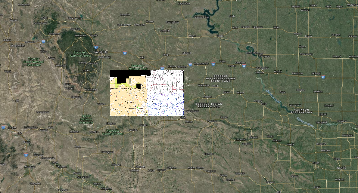
I manage a mapping system for the Pine Ridge Reservation in South Dakota and am trying to retrieve a raster layer but I keep getting this expanding black background/box. 

When I open the mbtiles file in Qgis it looks fine but when I retrieve the file through ArcGisArcGIS either as ana WMTS layer OR the Mapbox instructions for pulling layers into ArcGIS online of "Add > Add Layer from Web > A Tile Layer" there's black box around it that increases in size as as you zoom-out. 

See image.   

expanding black box

Here's some relevant details about my data:

  • The original file was converted from Geotiff to Mbtiles format in TileOven (active Linux fork of TileMill) and then uploaded to Mapbox and styled in mapboxmap box studio.
  • This is not a no-data border in the original geotiff. The original geotiff has only a tiny border that I'm not concerned about concealing.
  • The original geotiff was created using GDAL processing tools in Qgis
  • To convert the file from geotiff to Mbtiles in TileMill I used these instructions https://www.youtube.com/watch?v=05Et84xIgls
  • I made certain I set extentsextends in TileMill and ArcGIS online.
  • I also tried uploading the Geotiff directly to ArcGIS online and the same thing happens.
  • I'm using TileOven, QGIS 2.18 on Kubuntu 18.04 with KDE Plasma 5.12.6 Software

Mapbox does not have their own forum and I submitted a support request with Mapbox several days ago with no response but would rather share issue here in case it can help someone else.

Here's the ArcGIS Online integration URL provided by MapBox https://api.mapbox.com/styles/v1/dbartecchi/cjlgwhz4704j02rldjapn5wzc/tiles/256/{level}/{col}/{row}@2x?access_token=pk.eyJ1IjoiZGJhcnRlY2NoaSIsImEiOiJPV0cyMW1NIn0.D5p-ioo0SzDujMVD77ZQIg

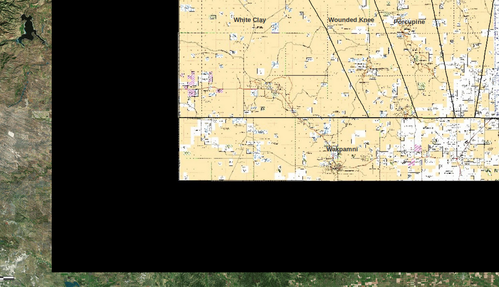
Here's the Mbtiles file opened in QGIS 2.18 looking exactly how it should look. enter image description here
I manage a mapping system for the Pine Ridge Reservation in South Dakota and am trying to retrieve a raster layer but I keep getting this expanding black background/box. When I open the mbtiles file in Qgis it looks fine but when I retrieve the file through ArcGis either as an WMTS layer OR the Mapbox instructions for pulling layers into ArcGIS online of "Add > Add Layer from Web > A Tile Layer" there's black box around it that increases in size as as you zoom-out. See image.  expanding black box

Here's some relevant details about my data:

  • The original file was converted from Geotiff to Mbtiles format in TileOven (active Linux fork of TileMill) and then uploaded to Mapbox and styled in mapbox studio.
  • This is not a no-data border in the original geotiff. The original geotiff has only a tiny border that I'm not concerned about concealing.
  • The original geotiff was created using GDAL processing tools in Qgis
  • To convert the file from geotiff to Mbtiles in TileMill I used these instructions https://www.youtube.com/watch?v=05Et84xIgls
  • I made certain I set extents in TileMill and ArcGIS online.
  • I also tried uploading the Geotiff directly to ArcGIS online and the same thing happens.
  • I'm using TileOven, QGIS 2.18 on Kubuntu 18.04 with KDE Plasma 5.12.6 Software

Mapbox does not have their own forum and I submitted a support request with Mapbox several days ago with no response but would rather share issue here in case it can help someone else.

Here's the ArcGIS Online integration URL provided by MapBox https://api.mapbox.com/styles/v1/dbartecchi/cjlgwhz4704j02rldjapn5wzc/tiles/256/{level}/{col}/{row}@2x?access_token=pk.eyJ1IjoiZGJhcnRlY2NoaSIsImEiOiJPV0cyMW1NIn0.D5p-ioo0SzDujMVD77ZQIg

Here's the Mbtiles file opened in QGIS 2.18 looking exactly how it should look. enter image description here

I manage a mapping system for the Pine Ridge Reservation in South Dakota and am trying to retrieve a raster layer but I keep getting this expanding black background/box. 

When I open the mbtiles file in Qgis it looks fine but when I retrieve the file through ArcGIS either as a WMTS layer OR the Mapbox instructions for pulling layers into ArcGIS online of "Add > Add Layer from Web > A Tile Layer" there's black box around it that increases in size as you zoom-out. 

See image. 

expanding black box

Here's some relevant details about my data:

  • The original file was converted from Geotiff to Mbtiles format in TileOven (active Linux fork of TileMill) and then uploaded to Mapbox and styled in map box studio.
  • This is not a no-data border in the original geotiff. The original geotiff has only a tiny border that I'm not concerned about concealing.
  • The original geotiff was created using GDAL processing tools in Qgis
  • To convert the file from geotiff to Mbtiles in TileMill I used these instructions https://www.youtube.com/watch?v=05Et84xIgls
  • I made certain I set extends in TileMill and ArcGIS online.
  • I also tried uploading the Geotiff directly to ArcGIS online and the same thing happens.
  • I'm using TileOven, QGIS 2.18 on Kubuntu 18.04 with KDE Plasma 5.12.6 Software

Here's the ArcGIS Online integration URL provided by MapBox https://api.mapbox.com/styles/v1/dbartecchi/cjlgwhz4704j02rldjapn5wzc/tiles/256/{level}/{col}/{row}@2x?access_token=pk.eyJ1IjoiZGJhcnRlY2NoaSIsImEiOiJPV0cyMW1NIn0.D5p-ioo0SzDujMVD77ZQIg

Here's the Mbtiles file opened in QGIS 2.18 looking exactly how it should look. enter image description here
added 189 characters in body; edited title
Source Link

Scaling black Black box around raster layer retreieved from Mapbox in ArcGIS online

I manage a mapping system for the Pine Ridge Reservation in South Dakota and am trying to retrieve a raster layer but I keep getting this expanding black background/box. When I open the mbtiles file in Qgis it looks fine but when I retrieve the file through ArcGis either as an WMTS layer OR the Mapbox instructions for pulling layers into ArcGIS online of "Add > Add Layer from Web > A Tile Layer" there's black box around it that increases in size as as you zoom-out. See image. expanding black box

Here's some relevant details about my data:

  • The original file was converted from Geotiff to Mbtiles format in TileOven (active Linux fork of TileMill) and then uploaded to Mapbox and styled in mapbox studio.
  • This is not a no-data border in the original geotiff. The original geotiff has only a tiny border that I'm not concerned about concealing.
  • The original geotiff was created using GDAL processing tools in Qgis
  • To convert the file from geotiff to Mbtiles in TileMill I used these instructions https://www.youtube.com/watch?v=05Et84xIgls
  • I made certain I set extents in TileMill and ArcGIS online.
  • I also tried uploading the Geotiff directly to ArcGIS online and the same thing happens.
  • I'm using TileOven, QGIS 2.18 on Kubuntu 18.04 with KDE Plasma 5.12.6 Software

Mapbox does not have their own forum and I submitted a support request with Mapbox several days ago with no response but would rather share issue here in case it can help someone else.

Here's the ArcGIS Online integration URL provided by MapBox https://api.mapbox.com/styles/v1/dbartecchi/cjlgwhz4704j02rldjapn5wzc/tiles/256/{level}/{col}/{row}@2x?access_token=pk.eyJ1IjoiZGJhcnRlY2NoaSIsImEiOiJPV0cyMW1NIn0.D5p-ioo0SzDujMVD77ZQIg

Here's the Mbtiles file opened in QGIS 2.18 looking exactly how it should look. enter image description here

Scaling black box around raster layer retreieved from Mapbox in ArcGIS online

I manage a mapping system for the Pine Ridge Reservation in South Dakota and am trying to retrieve a raster layer but I keep getting this expanding black background/box. When I open the mbtiles file in Qgis it looks fine but when I retrieve the file through ArcGis either as an WMTS layer OR the Mapbox instructions for pulling layers into ArcGIS online of "Add > Add Layer from Web > A Tile Layer" there's black box around it that increases in size as as you zoom-out. See image. expanding black box

Here's some relevant details about my data:

  • The original file was converted from Geotiff to Mbtiles format in TileOven (active Linux fork of TileMill) and then uploaded to Mapbox and styled in mapbox studio.
  • This is not a no-data border in the original geotiff. The original geotiff has only a tiny border that I'm not concerned about concealing.
  • The original geotiff was created using GDAL processing tools in Qgis
  • To convert the file from geotiff to Mbtiles in TileMill I used these instructions https://www.youtube.com/watch?v=05Et84xIgls
  • I made certain I set extents in TileMill and ArcGIS online.
  • I also tried uploading the Geotiff directly to ArcGIS online and the same thing happens.
  • I'm using TileOven, QGIS 2.18 on Kubuntu 18.04 with KDE Plasma 5.12.6 Software

Here's the ArcGIS Online integration URL provided by MapBox https://api.mapbox.com/styles/v1/dbartecchi/cjlgwhz4704j02rldjapn5wzc/tiles/256/{level}/{col}/{row}@2x?access_token=pk.eyJ1IjoiZGJhcnRlY2NoaSIsImEiOiJPV0cyMW1NIn0.D5p-ioo0SzDujMVD77ZQIg

Here's the Mbtiles file opened in QGIS 2.18 looking exactly how it should look. enter image description here

Black box around raster layer retreieved from Mapbox in ArcGIS online

I manage a mapping system for the Pine Ridge Reservation in South Dakota and am trying to retrieve a raster layer but I keep getting this expanding black background/box. When I open the mbtiles file in Qgis it looks fine but when I retrieve the file through ArcGis either as an WMTS layer OR the Mapbox instructions for pulling layers into ArcGIS online of "Add > Add Layer from Web > A Tile Layer" there's black box around it that increases in size as as you zoom-out. See image. expanding black box

Here's some relevant details about my data:

  • The original file was converted from Geotiff to Mbtiles format in TileOven (active Linux fork of TileMill) and then uploaded to Mapbox and styled in mapbox studio.
  • This is not a no-data border in the original geotiff. The original geotiff has only a tiny border that I'm not concerned about concealing.
  • The original geotiff was created using GDAL processing tools in Qgis
  • To convert the file from geotiff to Mbtiles in TileMill I used these instructions https://www.youtube.com/watch?v=05Et84xIgls
  • I made certain I set extents in TileMill and ArcGIS online.
  • I also tried uploading the Geotiff directly to ArcGIS online and the same thing happens.
  • I'm using TileOven, QGIS 2.18 on Kubuntu 18.04 with KDE Plasma 5.12.6 Software

Mapbox does not have their own forum and I submitted a support request with Mapbox several days ago with no response but would rather share issue here in case it can help someone else.

Here's the ArcGIS Online integration URL provided by MapBox https://api.mapbox.com/styles/v1/dbartecchi/cjlgwhz4704j02rldjapn5wzc/tiles/256/{level}/{col}/{row}@2x?access_token=pk.eyJ1IjoiZGJhcnRlY2NoaSIsImEiOiJPV0cyMW1NIn0.D5p-ioo0SzDujMVD77ZQIg

Here's the Mbtiles file opened in QGIS 2.18 looking exactly how it should look. enter image description here

Source Link

Scaling black box around raster layer retreieved from Mapbox in ArcGIS online

I manage a mapping system for the Pine Ridge Reservation in South Dakota and am trying to retrieve a raster layer but I keep getting this expanding black background/box. When I open the mbtiles file in Qgis it looks fine but when I retrieve the file through ArcGis either as an WMTS layer OR the Mapbox instructions for pulling layers into ArcGIS online of "Add > Add Layer from Web > A Tile Layer" there's black box around it that increases in size as as you zoom-out. See image. expanding black box

Here's some relevant details about my data:

  • The original file was converted from Geotiff to Mbtiles format in TileOven (active Linux fork of TileMill) and then uploaded to Mapbox and styled in mapbox studio.
  • This is not a no-data border in the original geotiff. The original geotiff has only a tiny border that I'm not concerned about concealing.
  • The original geotiff was created using GDAL processing tools in Qgis
  • To convert the file from geotiff to Mbtiles in TileMill I used these instructions https://www.youtube.com/watch?v=05Et84xIgls
  • I made certain I set extents in TileMill and ArcGIS online.
  • I also tried uploading the Geotiff directly to ArcGIS online and the same thing happens.
  • I'm using TileOven, QGIS 2.18 on Kubuntu 18.04 with KDE Plasma 5.12.6 Software

Here's the ArcGIS Online integration URL provided by MapBox https://api.mapbox.com/styles/v1/dbartecchi/cjlgwhz4704j02rldjapn5wzc/tiles/256/{level}/{col}/{row}@2x?access_token=pk.eyJ1IjoiZGJhcnRlY2NoaSIsImEiOiJPV0cyMW1NIn0.D5p-ioo0SzDujMVD77ZQIg

Here's the Mbtiles file opened in QGIS 2.18 looking exactly how it should look. enter image description here