added 157 characters in body
Source Link

The problem

  • Need to convert a raster .tif tile (DOWNLOAD) from WGS84 to GDA94 Albers;
  • Need to convert its stored pixel info from Float32 to 8 bit UNSIGNED;
  • Need Compression set to "NONE";
  • Need to multiply it by 40; and
  • Need to set its pixel size to 30x30 metres.

My steps

1 - Project the raster tile to GDA94 Albers, stating "30" as Output cell size: ArcMap -> Project raster tool;

2 - Recalculated the pixel values multiplying by 40: QGIS -> Raster calculator (Syntax = "tile_name" * 40);

3 - Convert the pixel depth from Float32 to 8-Unsigned: ArcMap -> copy raster tool.

My results

As you can see from the picture below, I have sampled some points and retrieved the info from the original tile and compared to my output raster: enter image description here
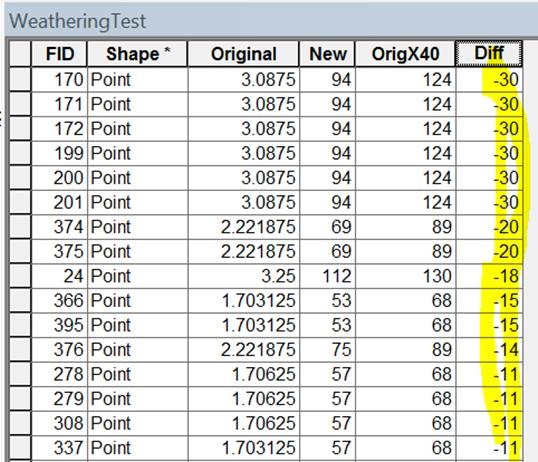
After multiplying by 40, the result I SHOULD expect should be equal to the "OrigX40", however, my results are shown in the "New" column and there's a substantial difference.

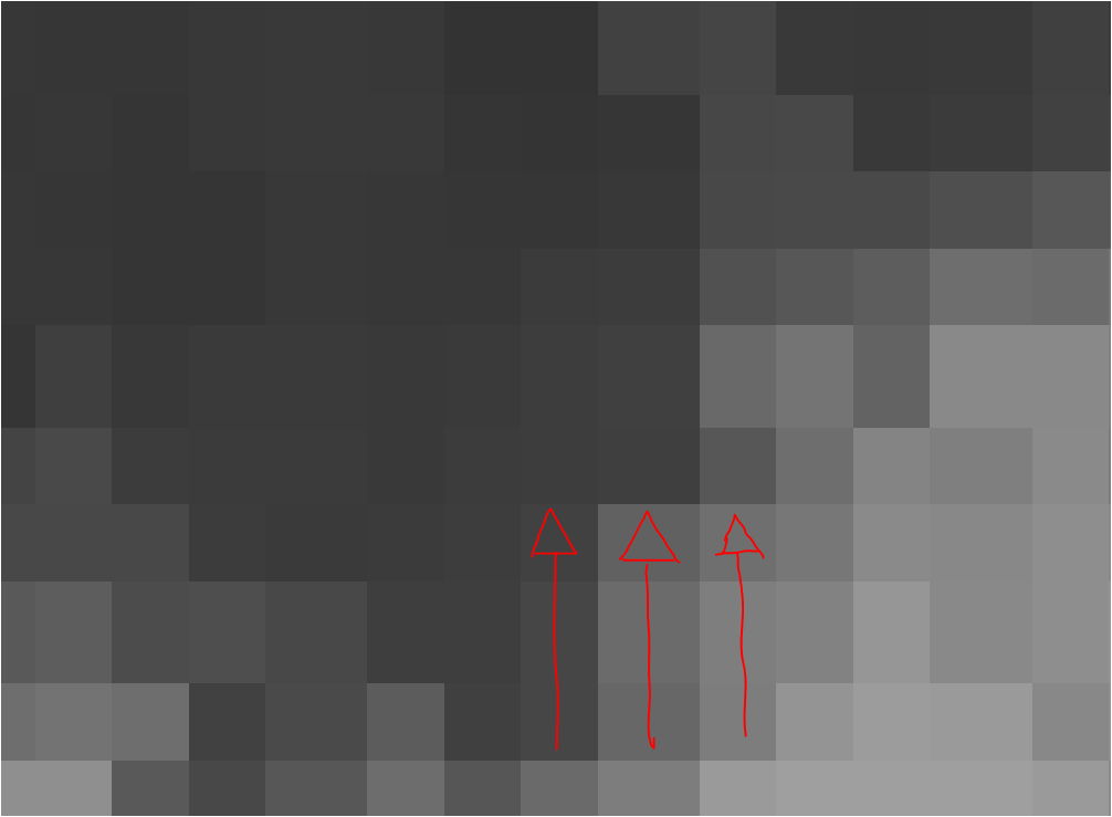
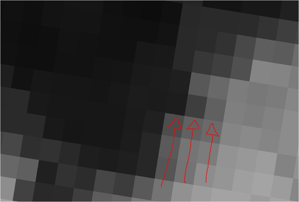
In addition, is it normal that after reprojecting the final output it shifts the cells' orientation from tilted (pic above) to non-tilted (pic below)?

enter image description here

enter image description here

This shifted array of cells also contributes to the fact that when I sample a point that is on the fringe between 2 cells of the final output, obviously it does not match with the expected Float value (divided by 40) of the original tile. Is this normal or should the final output maintain a shifted array-like pixel grid, same as the original?

My tools

I have used a combination of QGIS 3.6 Noosa and ArcMap 10 (no Spatial Analyst extension -> no raster calculator!).

My expectations

My expectations are that the final output should align with the original layer and every cell stores the same info the original cells store but times 40.

What am I doing wrong?

The problem

  • Need to convert a raster .tif tile (DOWNLOAD) from WGS84 to GDA94 Albers;
  • Need to convert its stored pixel info from Float32 to 8 bit UNSIGNED;
  • Need Compression set to "NONE";
  • Need to multiply it by 40; and
  • Need to set its pixel size to 30x30 metres.

My steps

1 - Project the raster tile to GDA94 Albers, stating "30" as Output cell size: ArcMap -> Project raster tool;

2 - Recalculated the pixel values multiplying by 40: QGIS -> Raster calculator (Syntax = "tile_name" * 40);

3 - Convert the pixel depth from Float32 to 8-Unsigned: ArcMap -> copy raster tool.

My results

As you can see from the picture below, I have sampled some points and retrieved the info from the original tile and compared to my output raster: enter image description here

After multiplying by 40, the result I SHOULD expect should be equal to the "OrigX40", however, my results are shown in the "New" column and there's a substantial difference.

In addition, is it normal that after reprojecting the final output it shifts the cells' orientation from tilted (pic above) to non-tilted (pic below)?

enter image description here

enter image description here

This shifted array of cells also contributes to the fact that when I sample a point that is on the fringe between 2 cells of the final output, obviously it does not match with the expected Float value (divided by 40) of the original tile. Is this normal or should the final output maintain a shifted array-like pixel grid, same as the original?

My tools

I have used a combination of QGIS 3.6 Noosa and ArcMap 10 (no Spatial Analyst extension -> no raster calculator!).

My expectations

My expectations are that the final output should align with the original layer and every cell stores the same info the original cells store but times 40.

What am I doing wrong?
deleted 18 characters in body
Source Link
PolyGeo
  • 65.4k
  • 29
  • 114
  • 345

The problem

  • Need to convert a raster .tif tile (DOWNLOAD) from WGS84 to GDA94 Albers;
  • Need to convert its stored pixel info from Float32 to 8 bit UNSIGNED;
  • Need Compression set to "NONE";
  • Need to multiply it by 40; and
  • Need to set its pixel size to 30x30 metres.

My steps

1 - Project the raster tile to GDA94 Albers, stating "30" as Output cell size: ArcMap -> Project raster tool;

2 - Recalculated the pixel values multiplying by 40: QGIS -> Raster calculator (Syntax = "tile_name" * 40);

3 - Convert the pixel depth from Float32 to 8-Unsigned: ArcMap -> copy raster tool.

My results

As you can see from the picture below, I have sampled some points and retrieved the info from the original tile and compared to my output raster: enter image description here

After multiplying by 40, the result I SHOULD expect should be equal to the "OrigX40", however, my results are shown in the "New" column and there's a substantial difference.

In addition, is it normal that after reprojecting the final output it shifts the cells' orientation from tilted (pic above) to non-tilted (pic below)?

enter image description here

enter image description here

This shifted array of cells also contributes to the fact that when I sample a point that is on the fringe between 2 cells of the final output, obviously it does not match with the expected Float value (divided by 40) of the original tile. Is this normal or should the final output maintain a shifted array-like pixel grid, same as the original?

My tools

I have used a combination of QGIS 3.6 Noosa and ArcMap 10 (no Spatial Analyst extension -> no raster calculator!).

What am I doing wrong?

Thank you all!

The problem

  • Need to convert a raster .tif tile (DOWNLOAD) from WGS84 to GDA94 Albers;
  • Need to convert its stored pixel info from Float32 to 8 bit UNSIGNED;
  • Need Compression set to "NONE";
  • Need to multiply it by 40; and
  • Need to set its pixel size to 30x30 metres.

My steps

1 - Project the raster tile to GDA94 Albers, stating "30" as Output cell size: ArcMap -> Project raster tool;

2 - Recalculated the pixel values multiplying by 40: QGIS -> Raster calculator (Syntax = "tile_name" * 40);

3 - Convert the pixel depth from Float32 to 8-Unsigned: ArcMap -> copy raster tool.

My results

As you can see from the picture below, I have sampled some points and retrieved the info from the original tile and compared to my output raster: enter image description here

After multiplying by 40, the result I SHOULD expect should be equal to the "OrigX40", however, my results are shown in the "New" column and there's a substantial difference.

In addition, is it normal that after reprojecting the final output it shifts the cells' orientation from tilted (pic above) to non-tilted (pic below)?

enter image description here

enter image description here

This shifted array of cells also contributes to the fact that when I sample a point that is on the fringe between 2 cells of the final output, obviously it does not match with the expected Float value (divided by 40) of the original tile. Is this normal or should the final output maintain a shifted array-like pixel grid, same as the original?

My tools

I have used a combination of QGIS 3.6 Noosa and ArcMap 10 (no Spatial Analyst extension -> no raster calculator!).

What am I doing wrong?

added 676 characters in body
Source Link

The problem

  • Need to convert a raster .tif tile (DOWNLOAD) from WGS84 to GDA94 Albers;
  • Need to convert its stored pixel info from Float32 to 8 bit UNSIGNED;
  • Need Compression set to "NONE";
  • Need to multiply it by 40; and
  • Need to set its pixel size to 30x30 metres.

My steps

1 - Project the raster tile to GDA94 Albers, stating "30" as Output cell size: ArcMap -> Project raster tool;

2 - Recalculated the pixel values multiplying by 40: QGIS -> Raster calculator (Syntax = "tile_name" * 40);

3 - Convert the pixel depth from Float32 to 8-Unsigned: ArcMap -> copy raster tool.

My results

As you can see from the picture below, I have sampled some points and retrieved the info from the original tile and compared to my output raster: enter image description here

After multiplying by 40, the result I SHOULD expect should be equal to the "OrigX40", however, my results are shown in the "New" column and there's a substantial difference.

In addition, is it normal that after reprojecting the final output it shifts the cells' orientation from tilted (pic above) to non-tilted (pic below)?

enter image description here

enter image description here

This shifted array of cells also contributes to the fact that when I sample a point that is on the fringe between 2 cells of the final output, obviously it does not match with the expected Float value (divided by 40) of the original tile. Is this normal or should the final output maintain a shifted array-like pixel grid, same as the original?

My tools

I have used a combination of QGIS 3.6 Noosa and ArcMap 10 (no Spatial Analyst extension -> no raster calculator!).

What am I doing wrong?

Thank you all!

The problem

  • Need to convert a raster .tif tile (DOWNLOAD) from WGS84 to GDA94 Albers;
  • Need to convert its stored pixel info from Float32 to 8 bit UNSIGNED;
  • Need Compression set to "NONE";
  • Need to multiply it by 40; and
  • Need to set its pixel size to 30x30 metres.

My steps

1 - Project the raster tile to GDA94 Albers, stating "30" as Output cell size: ArcMap -> Project raster tool;

2 - Recalculated the pixel values multiplying by 40: QGIS -> Raster calculator (Syntax = "tile_name" * 40);

3 - Convert the pixel depth from Float32 to 8-Unsigned: ArcMap -> copy raster tool.

My results

As you can see from the picture below, I have sampled some points and retrieved the info from the original tile and compared to my output raster: enter image description here

After multiplying by 40, the result I SHOULD expect should be equal to the "OrigX40", however, my results are shown in the "New" column and there's a substantial difference.

In addition, is it normal that after reprojecting the final output it shifts the cells' orientation from tilted (pic above) to non-tilted (pic below)?

enter image description here

enter image description here

This shifted array of cells also contributes to the fact that when I sample a point that is on the fringe between 2 cells of the final output, obviously it does not match with the expected Float value (divided by 40) of the original tile. Is this normal or should the final output maintain a shifted array-like pixel grid, same as the original?

My tools

I have used a combination of QGIS 3.6 Noosa and ArcMap 10 (no Spatial Analyst extension -> no raster calculator!).

What am I doing wrong?

Thank you all!

added 35 characters in body
Source Link
Loading
added 1 character in body
Source Link
Loading
Source Link
Loading