Bounty Ended with 100 reputation awarded by CommunityBot
more info
Source Link
Martin F
  • 9k
  • 38
  • 60

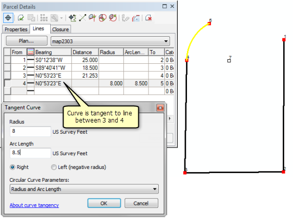
According to desktop.arcgis.com/en/arcmap/10.3/manage-data/editing-parcels/tangent-curve.htm you can enter curves via the Tangent Curve dialog.

enter image description here

The following assumes that you do have tangent data available. For each curve, you need the direction of the tangent to the curve, the arc length, the curve radius, and L/R (left or right). You would actually ignore both chord parameters (its direction and length).

Typically, the curve's tangent is the direction of the previous straight segment. For now, let's assume that's the case in your parcel: The two legal description snippets you show both cut off the previous course data so we cannot say exactly what to enter for them, but the radius and arc length would be 125.0 56.38 L and 125.0 90.89 L for your 'blue' and 'green' curves, respectively.

There are many different parameters that can be used to describe a curve and different land survey regulations follow different conventions. Your example curve descriptions show redundant data and, if you prefer, you could choose different parameters to enter after making another selection from the Circular Curve Parameters drop-down.

If a curve is not tangent to its previous line segment, you may have to infer the tangent's direction from other legal description data, if available. It looks like you may be able to do this via the Curve Calculator tool.

If you cannot determine the tangent's direction from any other data or toolThanks to a link given by Gabriel, it looks like you cannot use ArcGIS in this case. (I'm no expert, so someone else may have to chime in.) There are other tools out there that do allow entry of noncan enter non-tangenttangential curves. One such tool is Copan for Windows-- see desktop.arcgis.com/en/arcmap/10.3/manage-data/creating-new-features/about-creating-a-line-with-the-traverse-window.htm. It's completely free In your case, you would use the Chord Direction option, as that's what you have.


If you cannot determine the tangent's direction from any other data or tool, it looks like you cannot use ArcGIS in this case. (I'm no expert, so someone else may have to chime in.) There are other tools out there that *do* allow entry of *non*-tangent curves. One such tool is [Copan for Windows][5]. It's completely free.

According to desktop.arcgis.com/en/arcmap/10.3/manage-data/editing-parcels/tangent-curve.htm you can enter curves via the Tangent Curve dialog.

enter image description here

The following assumes that you do have tangent data available. For each curve, you need the direction of the tangent to the curve, the arc length, the curve radius, and L/R (left or right). You would actually ignore both chord parameters (its direction and length).

Typically, the curve's tangent is the direction of the previous straight segment. For now, let's assume that's the case in your parcel: The two legal description snippets you show both cut off the previous course data so we cannot say exactly what to enter for them, but the radius and arc length would be 125.0 56.38 L and 125.0 90.89 L for your 'blue' and 'green' curves, respectively.

There are many different parameters that can be used to describe a curve and different land survey regulations follow different conventions. Your example curve descriptions show redundant data and, if you prefer, you could choose different parameters to enter after making another selection from the Circular Curve Parameters drop-down.

If a curve is not tangent to its previous line segment, you may have to infer the tangent's direction from other legal description data, if available. It looks like you may be able to do this via the Curve Calculator tool.

If you cannot determine the tangent's direction from any other data or tool, it looks like you cannot use ArcGIS in this case. (I'm no expert, so someone else may have to chime in.) There are other tools out there that do allow entry of non-tangent curves. One such tool is Copan for Windows. It's completely free.

According to desktop.arcgis.com/en/arcmap/10.3/manage-data/editing-parcels/tangent-curve.htm you can enter curves via the Tangent Curve dialog.

enter image description here

The following assumes that you do have tangent data available. For each curve, you need the direction of the tangent to the curve, the arc length, the curve radius, and L/R (left or right). You would actually ignore both chord parameters (its direction and length).

Typically, the curve's tangent is the direction of the previous straight segment. For now, let's assume that's the case in your parcel: The two legal description snippets you show both cut off the previous course data so we cannot say exactly what to enter for them, but the radius and arc length would be 125.0 56.38 L and 125.0 90.89 L for your 'blue' and 'green' curves, respectively.

There are many different parameters that can be used to describe a curve and different land survey regulations follow different conventions. Your example curve descriptions show redundant data and, if you prefer, you could choose different parameters to enter after making another selection from the Circular Curve Parameters drop-down.

If a curve is not tangent to its previous line segment, you may have to infer the tangent's direction from other legal description data, if available. It looks like you may be able to do this via the Curve Calculator tool.

Thanks to a link given by Gabriel, it looks like you can enter non-tangential curves -- see desktop.arcgis.com/en/arcmap/10.3/manage-data/creating-new-features/about-creating-a-line-with-the-traverse-window.htm. In your case, you would use the Chord Direction option, as that's what you have.


If you cannot determine the tangent's direction from any other data or tool, it looks like you cannot use ArcGIS in this case. (I'm no expert, so someone else may have to chime in.) There are other tools out there that *do* allow entry of *non*-tangent curves. One such tool is [Copan for Windows][5]. It's completely free.
added 207 characters in body
Source Link
Martin F
  • 9k
  • 38
  • 60

According to desktop.arcgis.com/en/arcmap/10.3/manage-data/editing-parcels/tangent-curve.htm you can enter curves via the Tangent Curve dialog.

enter image description here

The following assumes that you do have tangent data available. For each curve, you need the direction of the tangent to the curve, the arc length, the curve radius, and L/R (left or right). You would actually ignore both chord parameters (its direction and length).

Typically, the curve's tangent is the direction of the previous straight segment. For now, let's assume that's the case in your parcel: The two legal description snippets you show both cut off the previous course data so we cannot say exactly what to enter for them, but the radius and arc length would be 125.0 56.38 L and 125.0 90.89 L for your 'blue' and 'green' curves, respectively.

There are many different parameters that can be used to describe a curve and different land survey regulations follow different conventions. Your example curve descriptions show redundant data and, if you prefer, you could choose different parameters to enter after making another selection from the Circular Curve Parameters drop-down.

If a curve is not tangent to its previous line segment, you may have to infer the tangent's direction from other legal description data, if available. It looks like you may be able to do this via the Curve Calculator tool.

If you cannot determine the tangent's direction from any other data or tool, it looks like you cannot use ArcGIS in this case. (I'm no expert, so someone else may have to chime in.) There are other tools out there that do allow entry of non-tangent curves. One such tool is Copan for Windows. It's completely free.

According to desktop.arcgis.com/en/arcmap/10.3/manage-data/editing-parcels/tangent-curve.htm you can enter curves via the Tangent Curve dialog.

enter image description here

The following assumes that you do have tangent data available. For each curve, you need the direction of the tangent to the curve, the arc length, the curve radius, and L/R (left or right). You would actually ignore both chord parameters (its direction and length).

Typically, the curve's tangent is the direction of the previous straight segment. For now, let's assume that's the case in your parcel: The two legal description snippets you show both cut off the previous course data so we cannot say exactly what to enter for them, but the radius and arc length would be 125.0 56.38 L and 125.0 90.89 L for your 'blue' and 'green' curves, respectively.

There are many different parameters that can be used to describe a curve and different land survey regulations follow different conventions. Your example curve descriptions show redundant data and, if you prefer, you could choose different parameters to enter after making another selection from the Circular Curve Parameters drop-down.

If a curve is not tangent to its previous line segment, you may have to infer the tangent's direction from other legal description data, if available.

If you cannot determine the tangent's direction from any other data, it looks like you cannot use ArcGIS in this case. (I'm no expert, so someone else may have to chime in.) There are other tools out there that do allow entry of non-tangent curves. One such tool is Copan for Windows. It's completely free.

According to desktop.arcgis.com/en/arcmap/10.3/manage-data/editing-parcels/tangent-curve.htm you can enter curves via the Tangent Curve dialog.

enter image description here

The following assumes that you do have tangent data available. For each curve, you need the direction of the tangent to the curve, the arc length, the curve radius, and L/R (left or right). You would actually ignore both chord parameters (its direction and length).

Typically, the curve's tangent is the direction of the previous straight segment. For now, let's assume that's the case in your parcel: The two legal description snippets you show both cut off the previous course data so we cannot say exactly what to enter for them, but the radius and arc length would be 125.0 56.38 L and 125.0 90.89 L for your 'blue' and 'green' curves, respectively.

There are many different parameters that can be used to describe a curve and different land survey regulations follow different conventions. Your example curve descriptions show redundant data and, if you prefer, you could choose different parameters to enter after making another selection from the Circular Curve Parameters drop-down.

If a curve is not tangent to its previous line segment, you may have to infer the tangent's direction from other legal description data, if available. It looks like you may be able to do this via the Curve Calculator tool.

If you cannot determine the tangent's direction from any other data or tool, it looks like you cannot use ArcGIS in this case. (I'm no expert, so someone else may have to chime in.) There are other tools out there that do allow entry of non-tangent curves. One such tool is Copan for Windows. It's completely free.

added further notes/conditions/advice about tangency
Source Link
Martin F
  • 9k
  • 38
  • 60

According to desktop.arcgis.com/en/arcmap/10.3/manage-data/editing-parcels/tangent-curve.htm you can enter curves via the Tangent Curve dialog. You

enter image description here

The following assumes that you do have tangent data available. For each curve, you need the direction of the tangent to the curve, that is, the direction of the previous straight segment, the arc length, the curve radius, and L/R (left or right). You would actually ignore both chord parameters (its direction and length).

enter image description here

The Typically, the curve's tangent is the direction of the previous straight segment. For now, let's assume that's the case in your parcel: The two legal description snippets you show both cut off the previous course data so we cannot say exactly what to enter for them, but the radius and arc length would be 125.0 56.38 L and 125.0 90.89 L for your 'blue' and 'green' curves, respectively.

BTW, thereThere are many different parameters that can be used to describe a curve and different land survey regulations follow different conventions. Your example curve descriptions show redundant data and, if you prefer, you could choose different parameters to enter after making another selection from the Circular Curve Parameters drop-down.

If a curve is not tangent to its previous line segment, you may have to infer the tangent's direction from other legal description data, if available.

If you cannot determine the tangent's direction from any other data, it looks like you cannot use ArcGIS in this case. (I'm no expert, so someone else may have to chime in.) There are other tools out there that do allow entry of non-tangent curves. One such tool is Copan for Windows. It's completely free.

According to desktop.arcgis.com/en/arcmap/10.3/manage-data/editing-parcels/tangent-curve.htm you can enter curves via the Tangent Curve dialog. You need the direction of the tangent to the curve, that is, the direction of the previous straight segment, the arc length, the curve radius, and L/R (left or right). You would actually ignore both chord parameters (its direction and length).

enter image description here

The two legal description snippets you show both cut off the previous course data so we cannot say exactly what to enter for them, but the radius and arc length would be 125.0 56.38 L and 125.0 90.89 L for your 'blue' and 'green' curves, respectively.

BTW, there are many different parameters that can be used to describe a curve and different land survey regulations follow different conventions.

According to desktop.arcgis.com/en/arcmap/10.3/manage-data/editing-parcels/tangent-curve.htm you can enter curves via the Tangent Curve dialog.

enter image description here

The following assumes that you do have tangent data available. For each curve, you need the direction of the tangent to the curve, the arc length, the curve radius, and L/R (left or right). You would actually ignore both chord parameters (its direction and length).

Typically, the curve's tangent is the direction of the previous straight segment. For now, let's assume that's the case in your parcel: The two legal description snippets you show both cut off the previous course data so we cannot say exactly what to enter for them, but the radius and arc length would be 125.0 56.38 L and 125.0 90.89 L for your 'blue' and 'green' curves, respectively.

There are many different parameters that can be used to describe a curve and different land survey regulations follow different conventions. Your example curve descriptions show redundant data and, if you prefer, you could choose different parameters to enter after making another selection from the Circular Curve Parameters drop-down.

If a curve is not tangent to its previous line segment, you may have to infer the tangent's direction from other legal description data, if available.

If you cannot determine the tangent's direction from any other data, it looks like you cannot use ArcGIS in this case. (I'm no expert, so someone else may have to chime in.) There are other tools out there that do allow entry of non-tangent curves. One such tool is Copan for Windows. It's completely free.

Source Link
Martin F
  • 9k
  • 38
  • 60
Loading