deleted 51 characters in body
Source Link
PolyGeo
  • 65.4k
  • 29
  • 114
  • 345

I had the same problem. The inconvenient is that QGIS seems that is not able to understand correctly the projection information stored on the .jp2 image files. I recommend you to follow these steps:

(This worked on QGIS 3.10 A Coruña)

  1. Open an empty QGIS project file.
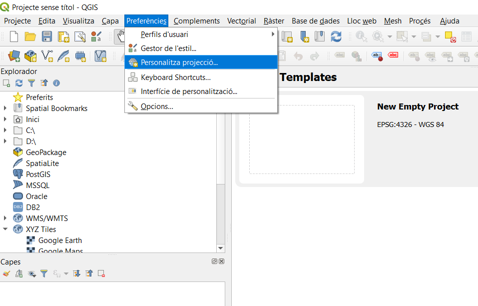
  2. Create a new projection by going to "preferences" -> "personalize projection". enter image description here
  3. Go to spatialreference.org to search the projections used for Mars.
  4. The projection usually used by NASA and the USGS for Mars is the IAU2000:49910: Mars Equidistant Cylindrical. We should add this projection on QGIS.
  5. Click on the IAU2000:49910 and then click on "Well Known Text as HTML".
  6. Copy that text, which should be:

PROJCS["Mars_Equidistant_Cylindrical", GEOGCS["Mars 2000", DATUM["D_Mars_2000", SPHEROID["Mars_2000_IAU_IAG",3396190.0,169.89444722361179]], PRIMEM["Greenwich",0], UNIT["Decimal_Degree",0.0174532925199433]], PROJECTION["Equidistant_Cylindrical"], PARAMETER["False_Easting",0], PARAMETER["False_Northing",0], PARAMETER["Central_Meridian",0], PARAMETER["Standard_Parallel_1",0], UNIT["Meter",1]]

This code defines the ellipsoid and the projection for Mars.

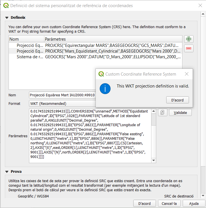
  1. Return to QGIS and paste on the opened window and give it an easy name to identify: enter image description here (Remember the format must be: WKT - Welll Known Text)
  2. Load the ESP_036925_1985_(COLOR/RED) images. Ignore possible errors about projections.
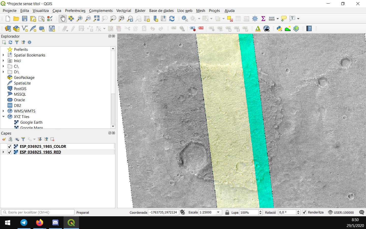
  3. Now change the project projection to IAU2000:49910. The images now should be correctly georeferenciatied: enter image description here
If this doesn't worked for you, I would recommend to update to a newer version of QGIS and try it again.

I hope this helped you, sorry for my English.

I had the same problem. The inconvenient is that QGIS seems that is not able to understand correctly the projection information stored on the .jp2 image files. I recommend you to follow these steps:

(This worked on QGIS 3.10 A Coruña)

  1. Open an empty QGIS project file.
  2. Create a new projection by going to "preferences" -> "personalize projection". enter image description here
  3. Go to spatialreference.org to search the projections used for Mars.
  4. The projection usually used by NASA and the USGS for Mars is the IAU2000:49910: Mars Equidistant Cylindrical. We should add this projection on QGIS.
  5. Click on the IAU2000:49910 and then click on "Well Known Text as HTML".
  6. Copy that text, which should be:

PROJCS["Mars_Equidistant_Cylindrical", GEOGCS["Mars 2000", DATUM["D_Mars_2000", SPHEROID["Mars_2000_IAU_IAG",3396190.0,169.89444722361179]], PRIMEM["Greenwich",0], UNIT["Decimal_Degree",0.0174532925199433]], PROJECTION["Equidistant_Cylindrical"], PARAMETER["False_Easting",0], PARAMETER["False_Northing",0], PARAMETER["Central_Meridian",0], PARAMETER["Standard_Parallel_1",0], UNIT["Meter",1]]

This code defines the ellipsoid and the projection for Mars.

  1. Return to QGIS and paste on the opened window and give it an easy name to identify: enter image description here (Remember the format must be: WKT - Welll Known Text)
  2. Load the ESP_036925_1985_(COLOR/RED) images. Ignore possible errors about projections.
  3. Now change the project projection to IAU2000:49910. The images now should be correctly georeferenciatied: enter image description here

If this doesn't worked for you, I would recommend to update to a newer version of QGIS and try it again.

Source Link

I had the same problem. The inconvenient is that QGIS seems that is not able to understand correctly the projection information stored on the .jp2 image files. I recommend you to follow these steps:

(This worked on QGIS 3.10 A Coruña)

  1. Open an empty QGIS project file.
  2. Create a new projection by going to "preferences" -> "personalize projection". enter image description here
  3. Go to spatialreference.org to search the projections used for Mars.
  4. The projection usually used by NASA and the USGS for Mars is the IAU2000:49910: Mars Equidistant Cylindrical. We should add this projection on QGIS.
  5. Click on the IAU2000:49910 and then click on "Well Known Text as HTML".
  6. Copy that text, which should be:

PROJCS["Mars_Equidistant_Cylindrical", GEOGCS["Mars 2000", DATUM["D_Mars_2000", SPHEROID["Mars_2000_IAU_IAG",3396190.0,169.89444722361179]], PRIMEM["Greenwich",0], UNIT["Decimal_Degree",0.0174532925199433]], PROJECTION["Equidistant_Cylindrical"], PARAMETER["False_Easting",0], PARAMETER["False_Northing",0], PARAMETER["Central_Meridian",0], PARAMETER["Standard_Parallel_1",0], UNIT["Meter",1]]

This code defines the ellipsoid and the projection for Mars.

  1. Return to QGIS and paste on the opened window and give it an easy name to identify: enter image description here (Remember the format must be: WKT - Welll Known Text)
  2. Load the ESP_036925_1985_(COLOR/RED) images. Ignore possible errors about projections.
  3. Now change the project projection to IAU2000:49910. The images now should be correctly georeferenciatied: enter image description here

If this doesn't worked for you, I would recommend to update to a newer version of QGIS and try it again.

I hope this helped you, sorry for my English.