deleted 23 characters in body
Source Link
Kadir Şahbaz
  • 78k
  • 57
  • 257
  • 404

I am new to QGIS and am exploring some open data sets from NYC as a self-guided project.

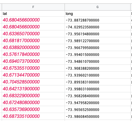
I am trying to map the branches of Brooklyn Public Library with a simple base map file of NYC streets, zip codes etc. The lat and long data for the library data looks like this:

CSV file

A text sample is as follows:

lat long
40.680456600000 -73.887288700000
40.680456600000 -74.029523500000
40.633650700000 -73.956194800000
40.681817000000 -73.989122700000
40.638920000000 -73.966799500000
40.576178400000 -73.994015000000
40.694073700000 -73.948610700000
40.675355100000 -73.908388200000
40.671344700000 -73.939602100000
40.704528500000 -73.899383100000
40.642131900000 -73.998031000000
40.683229000000 -73.968208400000
40.672480800000 -73.947958200000

I have tried aligning the projection to the NYC shapefile (which is correct because it lines up with the OpenStreetMap, WGS 84 (CRS84) OGC:CRS84) but the library coordinates keep getting placed in Pennsylvania, and seem to be incredibly close together.

Smushed library points, zoomed in A LOT

Yikes, something is off here

I have tried changing the projections and ended up in locations like Antarctica and Northern Africa... I truly have no idea how to fix this. I am a very new user, and even previously answered questions that were similar to this were a bit confusing to me.

EDIT: Please see below -- after successfully changing the projection to match the other layers and base map (OGC:CRS84 - WGS 84), we are in New York, but still slightly off. Note that there are libraries showing up in the water and in Manhattan, when they should only be in Brooklyn.

successfully in New York, but still off

I am new to QGIS and am exploring some open data sets from NYC as a self-guided project.

I am trying to map the branches of Brooklyn Public Library with a simple base map file of NYC streets, zip codes etc. The lat and long data for the library data looks like this:

CSV file

A text sample is as follows:

lat long
40.680456600000 -73.887288700000
40.680456600000 -74.029523500000
40.633650700000 -73.956194800000
40.681817000000 -73.989122700000
40.638920000000 -73.966799500000
40.576178400000 -73.994015000000
40.694073700000 -73.948610700000
40.675355100000 -73.908388200000
40.671344700000 -73.939602100000
40.704528500000 -73.899383100000
40.642131900000 -73.998031000000
40.683229000000 -73.968208400000
40.672480800000 -73.947958200000

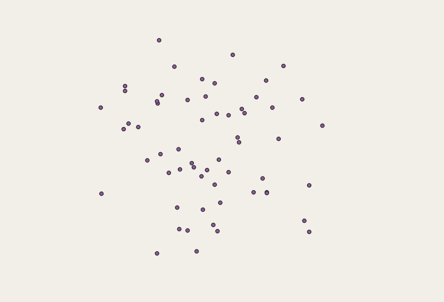
I have tried aligning the projection to the NYC shapefile (which is correct because it lines up with the OpenStreetMap, WGS 84 (CRS84) OGC:CRS84) but the library coordinates keep getting placed in Pennsylvania, and seem to be incredibly close together.

Smushed library points, zoomed in A LOT

Yikes, something is off here

I have tried changing the projections and ended up in locations like Antarctica and Northern Africa... I truly have no idea how to fix this. I am a very new user, and even previously answered questions that were similar to this were a bit confusing to me.

EDIT: Please see below -- after successfully changing the projection to match the other layers and base map (OGC:CRS84 - WGS 84), we are in New York, but still slightly off. Note that there are libraries showing up in the water and in Manhattan, when they should only be in Brooklyn.
successfully in New York, but still off

I am new to QGIS and am exploring some open data sets from NYC as a self-guided project.

I am trying to map the branches of Brooklyn Public Library with a simple base map file of NYC streets, zip codes etc. The lat and long data for the library data looks like this:

A text sample is as follows:

lat long
40.680456600000 -73.887288700000
40.680456600000 -74.029523500000
40.633650700000 -73.956194800000
40.681817000000 -73.989122700000
40.638920000000 -73.966799500000
40.576178400000 -73.994015000000
40.694073700000 -73.948610700000
40.675355100000 -73.908388200000
40.671344700000 -73.939602100000
40.704528500000 -73.899383100000
40.642131900000 -73.998031000000
40.683229000000 -73.968208400000
40.672480800000 -73.947958200000

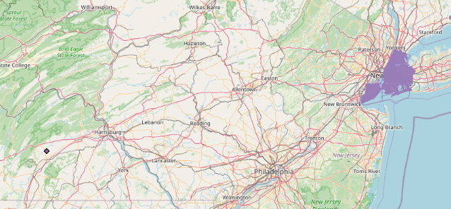
I have tried aligning the projection to the NYC shapefile (which is correct because it lines up with the OpenStreetMap, WGS 84 (CRS84) OGC:CRS84) but the library coordinates keep getting placed in Pennsylvania, and seem to be incredibly close together.

Smushed library points, zoomed in A LOT

Yikes, something is off here

I have tried changing the projections and ended up in locations like Antarctica and Northern Africa... I truly have no idea how to fix this. I am a very new user, and even previously answered questions that were similar to this were a bit confusing to me.

EDIT: Please see below -- after successfully changing the projection to match the other layers and base map (OGC:CRS84 - WGS 84), we are in New York, but still slightly off. Note that there are libraries showing up in the water and in Manhattan, when they should only be in Brooklyn.
successfully in New York, but still off

code formatting
Source Link
user2856
  • 69.6k
  • 6
  • 119
  • 203

I am new to QGIS and am exploring some open data sets from NYC as a self-guided project.

I am trying to map the branches of Brooklyn Public Library with a simple base map file of NYC streets, zip codes etc. The lat and long data for the library data looks like this:

CSV file

A text sample is as follows: lat long 40.680456600000 -73.887288700000 40.680456600000 -74.029523500000 40.633650700000 -73.956194800000 40.681817000000 -73.989122700000 40.638920000000 -73.966799500000 40.576178400000 -73.994015000000 40.694073700000 -73.948610700000 40.675355100000 -73.908388200000 40.671344700000 -73.939602100000 40.704528500000 -73.899383100000 40.642131900000 -73.998031000000 40.683229000000 -73.968208400000 40.672480800000 -73.947958200000

lat long
40.680456600000 -73.887288700000
40.680456600000 -74.029523500000
40.633650700000 -73.956194800000
40.681817000000 -73.989122700000
40.638920000000 -73.966799500000
40.576178400000 -73.994015000000
40.694073700000 -73.948610700000
40.675355100000 -73.908388200000
40.671344700000 -73.939602100000
40.704528500000 -73.899383100000
40.642131900000 -73.998031000000
40.683229000000 -73.968208400000
40.672480800000 -73.947958200000

I have tried aligning the projection to the NYC shapefile (which is correct because it lines up with the OpenStreetMap, WGS 84 (CRS84) OGC:CRS84) but the library coordinates keep getting placed in Pennsylvania, and seem to be incredibly close together.

Smushed library points, zoomed in A LOT

Yikes, something is off here

I have tried changing the projections and ended up in locations like Antarctica and Northern Africa... I truly have no idea how to fix this. I am a very new user, and even previously answered questions that were similar to this were a bit confusing to me.

EDIT: Please see below -- after successfully changing the projection to match the other layers and base map (OGC:CRS84 - WGS 84), we are in New York, but still slightly off. Note that there are libraries showing up in the water and in Manhattan, when they should only be in Brooklyn.
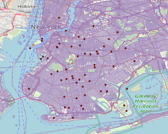
successfully in New York, but still off

I am new to QGIS and am exploring some open data sets from NYC as a self-guided project.

I am trying to map the branches of Brooklyn Public Library with a simple base map file of NYC streets, zip codes etc. The lat and long data for the library data looks like this:

CSV file

A text sample is as follows: lat long 40.680456600000 -73.887288700000 40.680456600000 -74.029523500000 40.633650700000 -73.956194800000 40.681817000000 -73.989122700000 40.638920000000 -73.966799500000 40.576178400000 -73.994015000000 40.694073700000 -73.948610700000 40.675355100000 -73.908388200000 40.671344700000 -73.939602100000 40.704528500000 -73.899383100000 40.642131900000 -73.998031000000 40.683229000000 -73.968208400000 40.672480800000 -73.947958200000

I have tried aligning the projection to the NYC shapefile (which is correct because it lines up with the OpenStreetMap, WGS 84 (CRS84) OGC:CRS84) but the library coordinates keep getting placed in Pennsylvania, and seem to be incredibly close together.

Smushed library points, zoomed in A LOT

Yikes, something is off here

I have tried changing the projections and ended up in locations like Antarctica and Northern Africa... I truly have no idea how to fix this. I am a very new user, and even previously answered questions that were similar to this were a bit confusing to me.

EDIT: Please see below -- after successfully changing the projection to match the other layers and base map (OGC:CRS84 - WGS 84), we are in New York, but still slightly off. Note that there are libraries showing up in the water and in Manhattan, when they should only be in Brooklyn.

successfully in New York, but still off

I am new to QGIS and am exploring some open data sets from NYC as a self-guided project.

I am trying to map the branches of Brooklyn Public Library with a simple base map file of NYC streets, zip codes etc. The lat and long data for the library data looks like this:

CSV file

A text sample is as follows:

lat long
40.680456600000 -73.887288700000
40.680456600000 -74.029523500000
40.633650700000 -73.956194800000
40.681817000000 -73.989122700000
40.638920000000 -73.966799500000
40.576178400000 -73.994015000000
40.694073700000 -73.948610700000
40.675355100000 -73.908388200000
40.671344700000 -73.939602100000
40.704528500000 -73.899383100000
40.642131900000 -73.998031000000
40.683229000000 -73.968208400000
40.672480800000 -73.947958200000

I have tried aligning the projection to the NYC shapefile (which is correct because it lines up with the OpenStreetMap, WGS 84 (CRS84) OGC:CRS84) but the library coordinates keep getting placed in Pennsylvania, and seem to be incredibly close together.

Smushed library points, zoomed in A LOT

Yikes, something is off here

I have tried changing the projections and ended up in locations like Antarctica and Northern Africa... I truly have no idea how to fix this. I am a very new user, and even previously answered questions that were similar to this were a bit confusing to me.

EDIT: Please see below -- after successfully changing the projection to match the other layers and base map (OGC:CRS84 - WGS 84), we are in New York, but still slightly off. Note that there are libraries showing up in the water and in Manhattan, when they should only be in Brooklyn.

successfully in New York, but still off

added 387 characters in body
Source Link
lisa
  • 31
  • 5

I am new to QGIS and am exploring some open data sets from NYC as a self-guided project.

I am trying to map the branches of Brooklyn Public Library with a simple base map file of NYC streets, zip codes etc. The lat and long data for the library data looks like this:

CSV file

A text sample is as follows: lat long 40.680456600000 -73.887288700000 40.680456600000 -74.029523500000 40.633650700000 -73.956194800000 40.681817000000 -73.989122700000 40.638920000000 -73.966799500000 40.576178400000 -73.994015000000 40.694073700000 -73.948610700000 40.675355100000 -73.908388200000 40.671344700000 -73.939602100000 40.704528500000 -73.899383100000 40.642131900000 -73.998031000000 40.683229000000 -73.968208400000 40.672480800000 -73.947958200000

I have tried aligning the projection to the NYC shapefile (which is correct because it lines up with the OpenStreetMap, WGS 84 (CRS84) OGC:CRS84) but the library coordinates keep getting placed in Pennsylvania, and seem to be incredibly close together.

Smushed library points, zoomed in A LOT

Yikes, something is off here

I have tried changing the projections and ended up in locations like Antarctica and Northern Africa... I truly have no idea how to fix this. I am a very new user, and even previously answered questions that were similar to this were a bit confusing to me.

EDIT: Please see below -- after successfully changing the projection to match the other layers and base map (OGC:CRS84 - WGS 84), we are in New York, but still slightly off. Note that there are libraries showing up in the water and in Manhattan, when they should only be in Brooklyn.

successfully in New York, but still off

I am new to QGIS and am exploring some open data sets from NYC as a self-guided project.

I am trying to map the branches of Brooklyn Public Library with a simple base map file of NYC streets, zip codes etc. The lat and long data for the library data looks like this:

CSV file

A text sample is as follows: lat long 40.680456600000 -73.887288700000 40.680456600000 -74.029523500000 40.633650700000 -73.956194800000 40.681817000000 -73.989122700000 40.638920000000 -73.966799500000 40.576178400000 -73.994015000000 40.694073700000 -73.948610700000 40.675355100000 -73.908388200000 40.671344700000 -73.939602100000 40.704528500000 -73.899383100000 40.642131900000 -73.998031000000 40.683229000000 -73.968208400000 40.672480800000 -73.947958200000

I have tried aligning the projection to the NYC shapefile (which is correct because it lines up with the OpenStreetMap, WGS 84 (CRS84) OGC:CRS84) but the library coordinates keep getting placed in Pennsylvania, and seem to be incredibly close together.

Smushed library points, zoomed in A LOT

Yikes, something is off here

I have tried changing the projections and ended up in locations like Antarctica and Northern Africa... I truly have no idea how to fix this. I am a very new user, and even previously answered questions that were similar to this were a bit confusing to me.

EDIT: Please see below -- after successfully changing the projection to match the other layers and base map (OGC:CRS84 - WGS 84), we are in New York, but still slightly off. Note that there are libraries showing up in the water and in Manhattan, when they should only be in Brooklyn.

successfully in New York, but still off

added text sample of csv file
Source Link
lisa
  • 31
  • 5
Loading
naming; removed appreciation
Source Link
Vince
  • 20.3k
  • 16
  • 48
  • 65
Loading
Source Link
lisa
  • 31
  • 5
Loading