Became Hot Network Question
added 10 characters in body; edited tags; edited title
Source Link
Taras
  • 34k
  • 4
  • 73
  • 148

Kenya Why GADM state/county shapefile won'tfor Kenya does not line up with OpenStreetMap data?

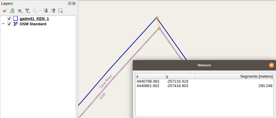
I am fairly new to QGIS and am using XYZ Tiles for OpenStreetMap and shapefile layers from GADM to see boundaries in Kenya (to start). I I have an OpenStreetMap layer and gadm41_Ken_1.shpgadm41_Ken_1.shp layer and the boundary lines are off from each other. I tried Check Geometry,"Check Geometry" but rendered no changes.

AnyoneDoes anyone have any tips or ideas?

enter image description here

Kenya state/county shapefile won't line up with OpenStreetMap

I am fairly new to QGIS and am using XYZ Tiles for OpenStreetMap and shapefile layers from GADM to see boundaries in Kenya (to start). I have an OpenStreetMap layer and gadm41_Ken_1.shp layer and the boundary lines are off from each other. I tried Check Geometry, but rendered no changes.

Anyone have any tips or ideas?

enter image description here

Why GADM state/county shapefile for Kenya does not line up with OpenStreetMap data?

I am fairly new to QGIS and am using XYZ Tiles for OpenStreetMap and shapefile layers from GADM to see boundaries in Kenya (to start). I have an OpenStreetMap layer and gadm41_Ken_1.shp layer and the boundary lines are off from each other. I tried "Check Geometry" but rendered no changes.

Does anyone have any tips or ideas?

enter image description here

Post Reopened by Kadir Şahbaz qgis
edited tags
Link
Noura
  • 3.4k
  • 3
  • 20
  • 41
added 220 characters in body
Added to review
Source Link
user2856
  • 69.6k
  • 6
  • 119
  • 203

I am fairly new to QGIS and am using XYZ Tiles for OpenStreetMap and shapefile layers from GADMGADM to see boundaries in Kenyaboundaries in Kenya (to start). I have an OpenStreetMap layer and gadm41_Ken_1.shp layer and the boundary lines are off from each other. I tried Check Geometry, but rendered no changes.

Anyone have any tips or ideas?

enter image description here

I am fairly new to QGIS and am using XYZ Tiles for OpenStreetMap and shapefile layers from GADM to see boundaries in Kenya (to start). I have an OpenStreetMap layer and gadm41_Ken_1.shp layer and the boundary lines are off from each other. I tried Check Geometry, but rendered no changes.

Anyone have any tips or ideas?

enter image description here

Post Closed as "Duplicate" by PolyGeo
deleted 31 characters in body; edited tags; edited title
Source Link
PolyGeo
  • 65.4k
  • 29
  • 114
  • 345
Loading
Source Link
Loading