replaced http://gis.stackexchange.com/ with https://gis.stackexchange.com/
Source Link

This is similar to Calculate polygon area inside extentCalculate polygon area inside extent

I have a few different polygon datasets which describe things like soil type, bushfire risk etc. For each property boundary we want to see how much of each soil type etc there is.

I tried Tabulate Interesection enter image description here
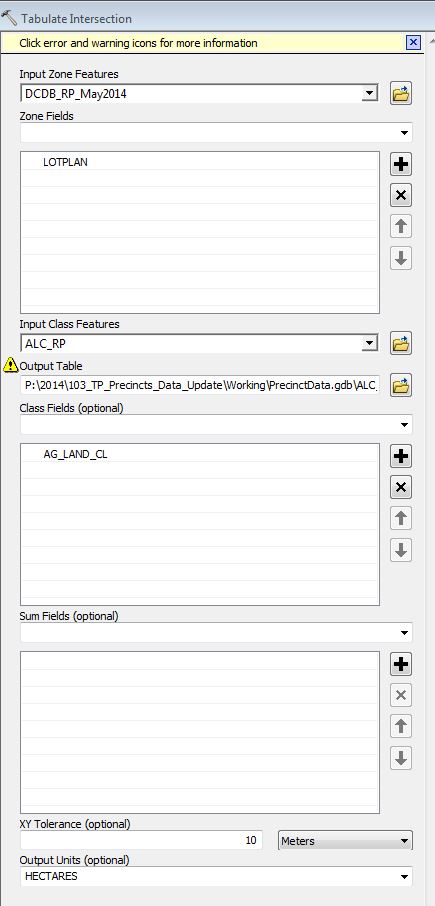
but it gives me percentages over 100% enter image description here . The 3 in blue are the same property.
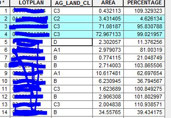
Any suggestions?

This is similar to Calculate polygon area inside extent

I have a few different polygon datasets which describe things like soil type, bushfire risk etc. For each property boundary we want to see how much of each soil type etc there is.

I tried Tabulate Interesection enter image description here

but it gives me percentages over 100% enter image description here . The 3 in blue are the same property.

Any suggestions?

edited tags
Link
PolyGeo
  • 65.4k
  • 29
  • 114
  • 345
added 38 characters in body
Source Link
GeorgeC
  • 8.3k
  • 7
  • 56
  • 143

This is similar to Calculate polygon area inside extent

I have a few different polygon datasets which describe things like soil type, bushfire risk etc. For each property boundary we want to see how much of each soil type etc there is.

I tried Tabulate Interesection enter image description here

but it gives me percentages over 100% enter image description here . The 3 in blue are the same property.

Any suggestions?

This is similar to Calculate polygon area inside extent

I have a few different polygon datasets which describe things like soil type, bushfire risk etc. For each property boundary we want to see how much of each soil type etc there is.

I tried Tabulate Interesection enter image description here

but it gives me percentages over 100% enter image description here

Any suggestions?

This is similar to Calculate polygon area inside extent

I have a few different polygon datasets which describe things like soil type, bushfire risk etc. For each property boundary we want to see how much of each soil type etc there is.

I tried Tabulate Interesection enter image description here

but it gives me percentages over 100% enter image description here . The 3 in blue are the same property.

Any suggestions?

Source Link
GeorgeC
  • 8.3k
  • 7
  • 56
  • 143
Loading