I am working with elevation data and performed a local operation to convert it from meters to feet.
I am interested in finding the area (expressed in percentage) that is above 4,000 feet, but I am having difficulty recalling how to do this.
I am working with elevation data and performed a local operation to convert it from meters to feet.
I am interested in finding the area (expressed in percentage) that is above 4,000 feet, but I am having difficulty recalling how to do this.
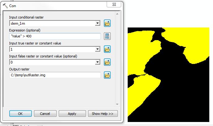
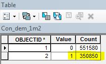
You can use the Con (Spatial Analyst) tool to calculate the area of specified elevation values. In this example, I stated that I wanted all elevation values of a floating point DEM > 400 = 1, else = 0. The black and yellow image is the result (Figure 1). Then, simply open the attribute table and look at the count next to the Value = 1 row (Figure 2). These units will be in map units, so in this case 350,850 m^2 or 0.35 km^2. As a percentage, elevation values >400m make up 39% of the area.
Figure 1

Figure 2

If your elevation raster is integer, Build Raster Attribute Table. Then, select the rows in the table of interest, and look at the Statistics for the Count field (right-click 'Count' -> Statistics). The SUM value is the number of pixels selected. Multiply this value by the area of one pixel (raster layer properties -> Source tab -> cell size). Repeat with no selection to get total area, or extract from raster properties (Source tab -> Columns and Rows). Divide to get percentage.
If your elevation raster is not integer, make it so, perhaps using Int or Reclassify.