25
votes

Whenever I do a presentation about anything related to GIS, I consider the level of knowledge of GIS of the audience. The worst times are definitely when I need to explain GIS to a group that has almost no knowledge about it. I said virtually, because by know everyone has interacted with some type of electronic map in one way or another (elephant in the room is Google Maps), so I usually start from there and explain everything that is necessary to create Google Maps. I have found that works quite well.

I know there are several formal definitions of GIS.

The questions are:

  • Which formal definition of GIS do you use?
  • How do you explain it to somebody that doesnt know much about the field in elevator pitch style? (30 seconds)
  • How do you explain it when you do have more time? (10 min)
5
  • 4
    I know you should definitely NOT say "it's like google maps". But i also too start from there, but realize it gives people the wrong idea. I also want to know this info (+1)
    – CaptDragon
    Commented Mar 8, 2012 at 16:28
  • @CaptDragon Oh I never say "it's like Google Maps". But I do start with a "What if you wanted to create something like Google Maps?". The data collection portion, the cartographic output, the data QA, the routing functionality, the imagery and elevation tilesets with the countours, search, the processes used, I can go on forever. At that point it becomes a much clearer analogy. Commented Mar 9, 2012 at 0:31
  • Starting with "What if you wanted to create something like Google Maps?" does sound a lot "like google maps". But i agree, by explaining the process people might start to get it. At least that is what you'd hope for. I think if it's your first time, the GIS explanation goes right over your head as it did mine when i was first explained GIS. The more you hear and see it, is when it starts sinking in. I'm liking James Fee's answer more and more as there are still many people that will never get it. Because they can't. You just have to tell them what they want to hear.
    – CaptDragon
    Commented Mar 9, 2012 at 14:13
  • 2
    If I find myself going down the Google Maps route, pointing out the limitations of GM helps to explain what GIS is along the lines of "You can't do such-and-such in GM... but you can do that in GIS". People think GM is amazing, so if you explain how it is quite limited, they then are forced to be even more amazed by GIS... either that or their eyes glaze over... just catch them before the fall :) Commented Mar 10, 2012 at 8:33
  • I have placed an historical lock on this question after it was cited as a precedent for gis.stackexchange.com/q/242669/115. If anyone wants to make a case for a Wiki Answer lock instead then please do so at Meta GIS SE.
    – PolyGeo
    Commented Jun 4, 2017 at 1:47

15 Answers 15

18
votes

enter image description here

0
14
votes

Depends on the person I'm talking to.

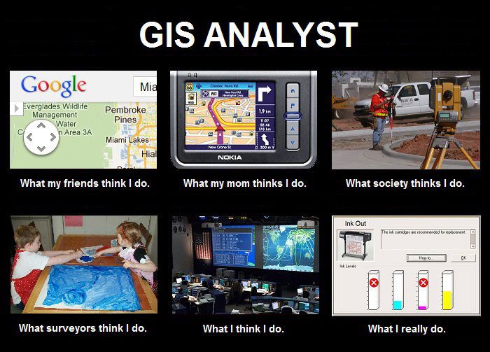
  1. My Mom: I make maps
  2. My Geek Friends: I make Google Maps
  3. Stranger on an airplane: "You know, like Google Earth?"
  4. Geek stranger on an airplane: "I'm in 'da cloud"
  5. Other Mapping Geeks: "I hate web mercator, don't you?"
3
  • Hell yeah. I do freakin' hate Web Mercator. Commented Mar 9, 2012 at 0:33
  • If you use Web Mercator by choice (and not because your forced to by your base tiles), you are probably a hipster. Commented Mar 14, 2012 at 20:58
  • Now go read Stephen Lead's wonderful illustrated version of this answer!
    – whuber
    Commented Mar 15, 2012 at 15:59
9
votes

As an "elevator style pitch" (which can also be expanded on), I sometimes use the the London cholera outbreak of 1854 as a simple way of explaning GIS. People seem to get it because its so obvous to us nowadays.

9
votes

Like ASPMapper, I also use the C.P. Snow example, but nowadays I normally start with something like: "I make my living from using Geographic Information Systems. GIS is some very clever computer tech for analysing the locations and relationships of things and places in the world, which can then be presented in maps."

-some vague reply usually follows indicating cautious luke-warm interest-

"Yes, you're right. It is a bit like Google Maps but you can do analysis with it too."

-more vague mumblings by way of reply that I usually interpret as an invitation to continue-

"You know your store loyalty card? Well, everything you buy and the stores you buy it in is logged against your address and the supermarket then can work out where to locate new stores and what special offers people in your neighbourhood are going to fall for."

-a much more excited response follows-

Having hit them in their wallets you have their interest beyond the limitations of Google. Next throw in gory stuff like the C.P. Snow example and some disaster mapping (forest fires works well) and you now have their undivided interest until something shiny catches their eye... after that, you've lost your audience.

1
  • "Having hit them in their wallets you have their interest beyond the limitations of Google. Next throw in gory stuff like the C.P. Snow example and some disaster mapping (forest fires works well) and you now have their undivided interest until something shiny catches their eye..." +1 :) Commented Mar 9, 2012 at 0:38
7
votes

I start on Google Earth and then work on their knowledge from there. A lot of people know Google Earth, it's a very basic GIS but it get's peoples thoughts on the right track (especially managers who don't know GIS) and then build on top of that thought with examples from your industry. You can play on the Web, Services, Desktop, Phone, tablet, mash ups ideas with Google Earth as the example as well for explaining ideas with systems.

I found this to work well BUT I agree with CaptDragon, you do need to be careful on giving the wrong impression but then there are some people who would struggle with a more detailed explanation of a GIS.

Also the GIS Wiki is a good starting point in using as a template to build peoples knowledge up.

2
  • Do you consider GE a GIS? Commented Mar 9, 2012 at 0:35
  • 1
    Of course - GE is a Geographic Information System. It stores and displays spatial data. Has some very basic analysis tools - measure tool. It's very very basic but it still applicable to the GIS domain. Some companies have used GE as their GIS platform. Not what I would suggest by any means!
    – Rob
    Commented Mar 12, 2012 at 7:46
6
votes

My super-brief answer is that GIS combines database and mapping technologies. Then, time permitting, I may give an example such as "I can take a map of the city zoning and quickly identify all of the parcels that are zoned MX3, have 3-story buildings, and were sold within the last 3 months."

1
  • 2
    Me too, My one-sentence answer is "It's a map where every point, line, or polygon on the map can be connected to a database".
    – Dan C
    Commented Mar 8, 2012 at 19:05
3
votes

The best way to describe it to most people is by using an example or two. If I know a bit about the person, I may try to tailor it to their background since GIS can be used in almost any field.

So let's say it's a doctor or science person. I might describe how GIS is used to study cancer by recording the location of leukemia incidents. Then one could figure out if there is a spatial correlation between incidents and certain pollution sources.

If the person is a truck driver, I might describe how I used a digital elevation model (DEM) to determine which routes use less fuel by factoring hills. Truck drivers usually know that it isn't just route miles but the incline of routes that affect fuel mileage and trip time.

If it's someone into politics, I could tell them how a GIS is used to study gerrymandering or how political boundaries affect voting.

And so on. Examples always work better than trying to give a textbook definition of GIS hardware and software, etc.

2
votes

I started giving a pitch like this to intro GIS courses with the goal of sending a message to people who didn't like computers:


GIS is 66% Information Systems and only 33% Maps. Basically it's asking questions about some phenomena of the landscape, using a computer to do an analysis, and occasionally mapping the results.

Doing GIS means spending time at the computer reviewing and understanding data, querying data, and perhaps writing special programs or classifying imagery. It's starting with raw data and using it to solve a problem with a spatial component. Some of the sub-tasks can require hours, days, even weeks of boring, repetitive clicking. And like anything involving computers, you're guaranteed to experience some reversals, especially at first.

GIS typically plays a supporting role to other pursuits: What is the estimated flood volume where we want to build the bridge? Which property owners have land within 1250-feet of the proposed zoning change? Can we identify habitat metrics for that endangered species to identify better placement of wind turbines? Is the spatial distribution of that illness meaningful, or is it just a byproduct of population density?

I know dozens of people using and applying GIS, but I only know _one _single _person, who is paid to make maps that get seen by the general public, and it's still less than 10% of what he does in a year.


Let's face it, to the average person, we're just a bunch of transponsters. And believe it or not, some people would rather take a phone call than georeference an image or write a program. :/

0
1
vote

I don't explain GIS; the term shouldn't be popularized.

I say that I'm a programmer who works with maps, and works on science and art problems related to maps.

5
  • curious as to why you think it should not be popularized. Commented Mar 14, 2012 at 20:47
  • See the the Wikipedia page on GIS: it's an over-broad term invented by a guy selling things. It's like 'cloud' - no self-respecting developer takes the word cloud seriously, but it has gained many incompatible meanings amongst non-experts. We also have terms already: software, geography, cartography, statistics, science. I'd rather be specific than attach what I do to a vague term that most people take to mean 'ArcGIS'.
    – tmcw
    Commented Mar 14, 2012 at 23:01
  • Some people consider GIS to include workflows, processes and people to be part of the gis. If you look at the wikipedia definition of information system en.wikipedia.org/wiki/Information_system you will notice that it refers to more than the technology stack. Commented Mar 15, 2012 at 8:41
  • That acronym-filled buzzword wikipedia article (complete with incomprehensible venn diagram) seems to be a good reason why not to use the term 'information system' either.
    – tmcw
    Commented Mar 15, 2012 at 20:11
  • @trncw sweet. I think you found a buzzword from the 60s! Commented Mar 15, 2012 at 20:33
1
vote

I used to start with the concept of mapping and then try to build from there, but I soon realized that it was that first image that I mentioned that always stuck in their mind. It also sells GIS short since maps are just the way we communicate the real work that is done with GIS. So I start with the idea of "geographic analysis" right away now and then back up and explain it - hopefully in terms that my listener can understand by associating it with their discipline.

I prefer connecting GIS more closely to database technology instead of mapping. That is really more appropriate since the GIS technology leverages DBMS by adding new analytical tools and methods that allow spatial relationships to be examined and avoids the idea that Google Maps/Earth is somehow parallel. Google may actually be a valid display method of GIS analysis in many cases but it does not provide GIS functionality (-unless we define GIS as "mapping" and then we get in trouble with surveyors.) We may like maps and feel comfortable creating map products, but if the public sees GIS as "dots on a map" we lose their attention and allow sideline groups to try to define Location Intelligence or LBS as splinter ideas. Every definition I hear about these concepts directly applies to GIS, nothing seperate.

As "professionals", we tend create our own problems by the struggle we openly have in defining our work. Sometimes we confuse it with technology and try to describe software functions. We get defensive and say "real GIS" does this or that to try differentiate from interactive mapping applications. Sometimes we even try to co-opt other technology like GPS or cartography. These disciplines are related and useful, but also distinct. We are "geographic analysts" and study the relationships between spatial phenonmena. It requires us to appreciate many other sciences, technologies (like DBMS or web programming) and unique concepts (like projections). Apologetic pandering to try to be understood is what causes our difficulty. Accept that other similar ideas exist and leverage them, just don't deviate from the core ideas that formed GIS back in 1960's - examine and describe relationships in data and communicate it through graphs, charts, maps, animations, text, whatever it takes. Our discipline has many specalities as well and being proficient in all of them is impossible, but the core remains regardless of the focus of our job.

1
vote

Here's another introduction that explains what is GIS is. First 10 minutes are a bit slow, but it gets better. Its about 1 1/2 hours of GIS intro at YouTube.

Introduction to GIS ( by KnowGIS.com )

Published on Dec 30, 2012

This video provides short (1 hour, 38 minute) introduction to geographic information systems (GIS). Presented by Jere Folgert of Bozeman, Montana USA.

0
votes

Whenever I am explaining GIS to someone from a cold start, I try to put it in terms that they will understand via common (or generally) common knowledge. I start out with the ever-popular "location, location, location," and try to emphasize how many phenomena seen in our daily lives can be better understood by knowing the specifics of the "where." From the "where," an analyst can work towards unique and insightful ways of determining "who, what, and why."

By that point, if they don't get it, I just say that I am like an author, but I tell stories with maps. :)

0
votes

My suggestion would be to work backwards, starting with a practical example they can relate to and then moving in to formal definitions and the ins-and-outs of GIS functionality. A good example to start with is GPS navigation systems in vehicles. The topological relationships that are engrained in their programming is a great example of GIS in action, and almost everyone is familiar with this technology. I think this is a great way to lead in to a discussion of GIS capabilities.

I suppose it might be a little tough to fit this in to a 30 second elevator conversation, but I would definitely go this route if I had 10 minutes. Another great example (as already suggested) is starting with a discussion about points cards, and how they're used to track shopping habits at the postal code level in Target marketing. I've even noticed lately (the last 2 years or so) that many cashiers have been asking me for my postal code as I'm making a purchase. I think most people would really have no idea how powerful a piece of information that is unless they have an awareness of what GIS can do with that information (ie - cluster analsis). Something as simple as the description of this technique at the link I pasted could actually be conveyed to the average person who is not familiar with statistical techniques or GIS. Just a general overview like this could build an understanding of the very basics of GIS as its being used in Target Marketing. I also think it would be an interesting topic to the non-GIS savvy person, as it actually something that impacts them directly, and most are not even aware of it.

As for a "formal" definition of GIS, I think a discussion of this sort allows the person leading the presentation to put forth a definition in layman's terms (after giving a few tangible examples).

0
votes

Here's an introduction that tries to explain what is GIS to non-techie crowd.

0
votes

compare it to the maps you see in crime shows that are riddled with pushpins, polaroids and post-its showing various details of the crimes that are being investigated

then say GIS digitizes that (and more...)

Not the answer you're looking for? Browse other questions tagged or ask your own question.