8

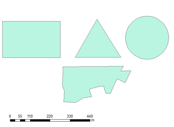
I created 4 basic polygons:

Sample data

And ran this script:

import arcpy
infc = r'D:\Scratch\POLYGONS.shp'
d=arcpy.Describe(infc)
SR=d.spatialReference
with arcpy.da.SearchCursor(infc, ("SHAPE@","LABEL")) as rows:
    for shp,label in rows:
        buf=shp.buffer(5)
        n=buf.partCount
        for i in xrange (n):
            prt=buf.getPart(i)
            pgon=arcpy.Polygon(prt,SR)
            arcpy.AddMessage((int(buf.area),int(pgon.area),label))

OUTPUT:

[68735, 68707, u'RECTANGLE']
[29892, 29846, u'TRIANGLE']
[47832, 47832, u'CIRCLE']
[55126, 55060, u"'COMPLEX'"]

Can anybody help me to understand the result?


I modified the code:

import arcpy
infc = r'....POLYGONS.shp'
outBuffer=r'...OUT_BUFFER.shp'
outPart=r'...SCRARCH\OUT_PART.shp'
d=arcpy.Describe(infc)
SR=d.spatialReference
with arcpy.da.SearchCursor(infc, ("SHAPE@","LABEL")) as rows:
    for shp,label in rows:
        buf=shp.buffer(5)
        arcpy.CopyFeatures_management(buf, outBuffer)
        n=buf.partCount
        for i in xrange (n):
            prt=buf.getPart(i)
            pgon=arcpy.Polygon(prt,SR)
            arcpy.CopyFeatures_management(pgon, outPart)
            break

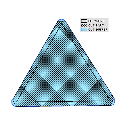
to check actual shapes. When working with geometries it would be expected that the first part of a single part polygon would be identical to the polygon itself.

This is an overlay of input and outputs and you can see where mismatch happened - at the corners:

enter image description here

Something sinister is happening inside arcpy.Polygon, it simplifies the shape using some sort of 'logic' handling true curves.

NOTE:

  • same result obtained with exporting to geodatabase
  • both outputs came up with input's spatial reference

This buffer issue is a part of a bigger job, where I have to deal with potentially multi-part polygons. The workaround I am using is explosion of buffer to single parts, using arcgis tool. It works, but ridiculously slow due to number of iterations. Why on earth the abc of geometry handling is not working?

Well, as it happens, after posting I realised I shouldn't be bothered with parts of the buffer, because label point of polygon is placed inside larger part of multipart polygon.

0

2 Answers 2

10

The sinister behaviour is not occurring at arcpy.Polygon as suggested by @FelixIP, it is occuring at the getPart() bit of code. I tweaked your code and ran it on a dataset with just a triangle. I had set the coordinate system to be British National Grid when I had created it.

import arcpy
arcpy.env.addOutputsToMap = True
infc = "tri"
outBuffer=r'c:\scratch\OUT_BUFFER.shp'
outPart=r'c:\scratch\OUT_PART.shp'
d=arcpy.Describe(infc)
SR=d.spatialReference
with arcpy.da.SearchCursor(infc, ("SHAPE@","LABEL")) as rows:
    for shp,label in rows:
        buf=shp.buffer(5)
        arcpy.CopyFeatures_management(buf, outBuffer)
        n=buf.partCount
        for i in xrange (n):
            prt=buf.getPart(i)
            # Print out sequence of XY points
            print(prt)
            for p in prt:
                print str(p.X ) + "," + str(p.Y)
            pgon=arcpy.Polygon(prt,SR)
            arcpy.CopyFeatures_management(pgon, outPart)
            break

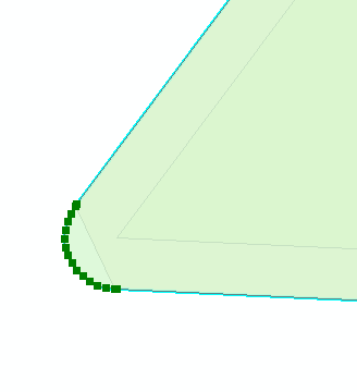
Zooming into one corner of the buffer of the triangle in edit mode we can see many vertices:

Vertices of buffer

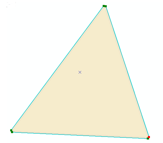
Infact there are 42 vertices for the whole geometry. My adjusted code reading the output of the getPart() returns only 11.

Clipped part

So the bug is occuring when the getPart() is called to return the Array of Points.

1
  • If you look at the WKT, you'll see that all vertices are maintained. buf.WKT.count(",") == 42. arcpy.FromWKT(buf.WKT, SR).area
    – Paul
    Commented Nov 11, 2016 at 22:03
7
+200

Instead of using getPart(), you can use WKT on the buffered polygon itself. It's not the exact shape of the buffer (due to approximating the 3 true curves on the triangle with 15 vertices each), but it's quite close. From the help:

Any true curves in the geometry will be densified into approximate curves in the WKT string.

import json
from pandas import DataFrame
import arcpy


header = ("type", "area", "vertices")
sr = arcpy.SpatialReference(3857) #WMAS
coords = [(-10136090, 3460507),
          (-10135313, 3461773),
          (-10134909, 3460488),
          (-10136090, 3460507)]
poly = arcpy.Polygon(arcpy.Array(arcpy.Point(x,y) for x,y in coords), sr)

buffer = poly.buffer(5)
part = arcpy.Polygon(buffer.getPart(0), sr)
wkt = arcpy.FromWKT(buffer.WKT, sr)
wkb = arcpy.FromWKB(buffer.WKB)
densify = arcpy.Polygon(buffer.densify("DISTANCE", 1, .00001).getPart(0), sr)
esriJSON = arcpy.AsShape(json.loads(buffer.JSON), True)

print(DataFrame([("buffer", buffer.area, buffer.pointCount)], columns=header))
df = DataFrame([("getPart", part.area, part.pointCount),
                ("WKT", wkt.area, wkt.pointCount),
                ("WKB", wkb.area, wkb.pointCount),
                ("densify", densify.area, densify.pointCount),
                ("JSON", esriJSON.area, esriJSON.pointCount)],
                 columns=header)
df["delta"] = [v - buffer.area for v in df["area"]]

print(df.sort(columns='delta',ascending=False))

And here's the output:

     type            area  vertices
0   buffer  775085.643363         9
      type           area  vertices         delta
4     JSON  775085.643363         9  1.641456e-08
3  densify  775085.633439      4235 -9.923947e-03
1      WKT  775085.297882        43 -3.454809e-01
0  getPart  775041.921399         9 -4.372196e+01
2      WKB  775041.921399         9 -4.372196e+01

Based on comment below from @faith_dur, the way to go is esri JSON!

2
  • 2
    Nice catch. Have tried GeoJSON as well? As far as I remember it could specify beziers/arcs separate from multipolygon.
    – fatih_dur
    Commented Nov 17, 2016 at 23:48
  • 1
    @fatih_dur, great point and that is the winner!
    – Paul
    Commented Nov 18, 2016 at 0:32

Your Answer

By clicking “Post Your Answer”, you agree to our terms of service and acknowledge you have read our privacy policy.

Not the answer you're looking for? Browse other questions tagged or ask your own question.