6

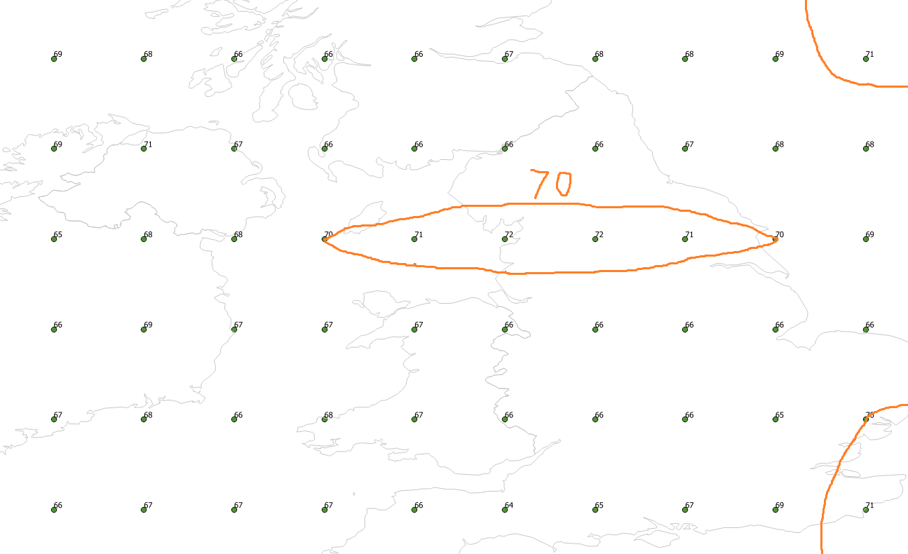
I have a point table containing values ranging from 0 to 100 and I would like to draw a contour line for the value 70. (See image below)

I know how to create contour lines in QGIS for raster data but now I would like to do it with vector data (my point table) using PostGIS so that it can be integrated in a python script.

Any idea on how to start?

EDIT: This question is different from Generating contour lines and filled contours from points as it doesn't involve raster data (neither in the input nor in the output)

enter image description here

2
  • this is a very complex clustering problem, and there isn't nearly enough information (afaik) to tackle it. For instance, how do you know both of those 70s aren't islands? Commented Nov 2, 2017 at 21:32
  • If you have a Python script that does contouring, you can create a fucntion in Postgis using pythonu extension Commented Nov 3, 2017 at 12:43

3 Answers 3

2

I think what you want is something like gdal_contour.

gdal_contour: Builds vector contour lines from a raster elevation model.


Usage: gdal_contour [-b <band>] [-a <attribute_name>] [-3d] [-inodata]
                    [-snodata n] [-i <interval>]
                    [-f <formatname>] [[-dsco NAME=VALUE] ...] [[-lco NAME=VALUE] ...]
                    [-off <offset>] [-fl <level> <level>...]
                    [-nln <outlayername>]
                    <src_filename> <dst_filename>

But PostGIS doesn't seem to implement anything like that from GDAL.

GDAL expects a input raster elevation model (DEM). PostGIS has a few DEM functions but I don't believe they'll help you here.

1

To create contour in PostGIS I usually use ST_ConvexHull or ST_ConcaveHull

Usage of it is simple as that:

SELECT
  st_convexhull(st_collect(geom)),
               pointsId
             FROM point_table 
             GROUP BY pointId;

But to create polygon like at your picture is not really easy.

You can try some other functions using this cheatsheet.

0

I am trying to do something very similar, I found an item at [fast contour lines using plain postgis1. it creates a contour map from your list of points. I get the impression it expects rectangle input.

My problem with this solution was the calling method, it uses array of data, a concept which is outside of most sql grammers.

My data weather point data, where geom the point location, speed a scalar value denoting the current wind speed and reading_time the value data was collected.

My calling code is

drop table foo;
create table foo(
    id serial,
    geom geometry ,
    break numeric 

);
insert into foo (geom,break )  
select 
    (contour_lines(  array_agg(geom),array_agg(speed::numeric), 
    ARRAY[ 0.0,0.5,1.0,1.5,2.0,2.5,3.0,3.5,4.0,4.5,5.0,5.5,6.0,6.5,7.0,7.5,8.0,8.5,9.0,9.5,10.0,10.5,11.0,11.5,12.0,12.5,13.0,13.5,14.0,14.5,15.0,15.5,16.0,16.5] )).geom ,  
    (contour_lines(  array_agg(geom),array_agg(speed::numeric), 
    ARRAY[ 0.0,0.5,1.0,1.5,2.0,2.5,3.0,3.5,4.0,4.5,5.0,5.5,6.0,6.5,7.0,7.5,8.0,8.5,9.0,9.5,10.0,10.5,11.0,11.5,12.0,12.5,13.0,13.5,14.0,14.5,15.0,15.5,16.0,16.5] )).break
from windproc where reading_time='2018-08-28 07:00:00+01'  and geom is not null and speed is not null;

Where array_agg creates an array of the object supply as an argument. The array construct creates a list of step/break values which is used a banding values for the generated contour lines.

The code for contour_lines is provided by the link. it expects a numeric value for scalar value (in my case speed) hence the cast.

The reason there is what appears to be a double called to contour_lines is that you need to get the break and geom answers provide by contour_lines function, but since array_agg is an aggrate function it can only appear in some parts of sql construct.

The result from this will give you a table called foo with the desired information in the geom column

Your Answer

By clicking “Post Your Answer”, you agree to our terms of service and acknowledge you have read our privacy policy.

Not the answer you're looking for? Browse other questions tagged or ask your own question.