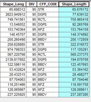
 I don't know why this is keep happening, but I created shapefile in QGIS and opened the shapefile from ArcGIS. I needed to create geodatabase to put in all of my shapefile, but whenever I do that, point shapefiles are fine, but my line shapefiles automatically create new field.
The main problem is that I cannot delete that new field in my attribute table, but I want them to be disappeared.
It is just one field that is keep showing up. I got the shape_leng for the shapefile's length(m) but when I export that into geodatabase, the new field shape_length comes up. It doesn't let me delete this field and values are very different.
Is there any ways to fix this or delete this field permanently?

shape_lengfield? If not, set the geodatabase to the same projection as the shapefile, and see if the values match up. If the projections are the same, could you edit your question to include a screenshot so that we can see how different the fields are?shape_leng?