8

I am trying to record tracks at a much finer scale than is possibly with GPS but hopefully using something simple and cheap, ideally an iPhone. The resolution for track data I am after is around 10-20cm.

The location of the track, and even the scale is not as important as the fine details of the shape of the track.

What I have in mind as the ideal solution is an iPhone app that uses the camera in conjunction with the other sensors to record a track in a similar way to an optical mouse detecting movement over a desk's surface.

So you would hold the phone with the camera facing down and walk the track. The app would trace the moving surface and infer where it is going, using the gyro and accelerometer to help correct for tilting the camera. It would also use the gyro and to a lesser extent the compass to help correct and detect the turns in the track. The height of the phone off the ground I don't think could be sensed or inferred but you could just enter that and hold it carefully at a consistent height. The led could be on to aid detection through shadows.

If you happen to be walking in a track that finished where it started you could mark that in some way to close the loop and it would try and correct it if the ends didn't meet up, and if you walked a long way, perhaps > 50m it could also use gps data to calibrate the scale of the track, but probably not really contribute much to the details of the tracks geometry.

So does something like this even exist in any form iphone or otherwise? Is there anything which is simpler eg it just uses the gyro/compass and a pedometer style measurement method? Is there some completely different cheap simple method?

6
  • 6
    10-20cm Accuracy requires high end GPS tech ($10,000+) trimble.com/mappingGIS/pro6.aspx?dtID=applications&
    – Mapperz
    Commented Jul 17, 2012 at 14:45
  • 1
    With an iPhone probably +- 10-20m at best and only where strong signal. Commented Jul 17, 2012 at 18:07
  • 3
    No offence, but did anyone actually read my question? I don't want to use a GPS or the GPS signal. I know GPS isn't accurate enough for what I want. Commented Jul 18, 2012 at 3:12
  • 1
    If you want to find out specific capabilities of an iPhone unrelated to GPS, the Apple Stack Exchange might be a better place for your question. c.f. apple.stackexchange.com/questions/10722/…
    – Sean
    Commented Jul 18, 2012 at 12:59
  • Bread crumbs or cotton?
    – mdsumner
    Commented Feb 12, 2013 at 10:47

4 Answers 4

5

Use a bluetooth gps device with your iPhone

enter image description here

Dual (xgps150A) bluetooth GPS receiver +/- 2.5m accuracy $100

Technical Specs

GPS
    65-channel SkyTraq GPS chipset
    WAAS/EGNOS compatible
    Accuracy: +/-2.5m (CEP)
    Fast location acquisition times: under 30 secs (warm or cold start)
    Position updates: at least once per second
    Maximum speed: 1000 kts / 1150 mph
    Maximum altitude: 18,000 m / 59,000 ft

http://www.gpscentral.ca/products/dual-xgps150A-bluetooth-gps-receiver.html

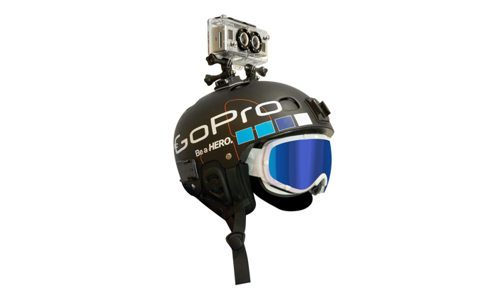
GoPro has HD Camera with gyro

enter image description here

http://gopro.com/cameras/hd-hero2-outdoor-edition/

0
2

Yes, it is possible to track the motion of a smartphone with 1-5cm resolution using Photo-Inertial Metrology technology from RealityCap. This technology uses a sensor fusion algorithm that combines computer vision and IMU data (gyro and accelerometer). It measures relative motion only, but can be combined with the GPS on the smartphone if absolute positioning is required. See this video for a demonstration. RealityCap has an iOS SDK that provides this capability to app developers. An Android SDK is planned as well. Full disclosure: I am one of the founders of RealityCap. Ask me anything.

5
  • Perfect - I'm after essentially your indoor navigation app, but for outdoors to make high quality maps of cliffs and boulders. Commented Mar 11, 2014 at 12:16
  • Interesting. So is the idea that you would walk along the edge of the cliff to record a track that corresponds to the topology of the cliff?
    – Ben H
    Commented Mar 12, 2014 at 16:06
  • Yup exactly. These are commonly hand draw in guide books and quality is pretty variable. I don't want to get down into the SDK land, I'm after a generic mobile app that you just turn on and start recording a line exactly like most GPS apps like MotionX. Then locate those recorded shapes as best as possible and export as KML / GPX, or worst case just a shape in SVG etc. Same app would have have heaps of uses like domestic surveying. Being able to record a high fidelity shape, even with a low fidelity location, and then open in Sketchup / google earth to fine tune then export again would be gold Commented Apr 3, 2014 at 6:09
  • What about trying to get a kml of an underground subway tunnel, where no GPS is available, while riding the train?
    – Ant6n
    Commented May 19, 2016 at 12:20
  • @BrendanHeywood did you end up with a solution for this project? Is there anything open-source or freeware that can do this accelerometer/gyro maths on iOS or Android?
    – 0__
    Commented Jul 3, 2016 at 20:10
2

Just check visual odometry, that is what you mean. MIT guys have done something really inspiring, Google "visual odometry for GPS-denied environments", and you will see. And yes, may be still quite-cpu consuming for a tiny Smartphone, but everything is changing daily, it's a matter of time to get this idea come truth.

Cheers!

1

I've since discovered that the field of applications that do what I'm after is called Photogrammetry.

http://en.wikipedia.org/wiki/Photogrammetry

Still no iPhone apps that do this (that I've found), even though all the hardware is present waiting to be harnessed. Maybe it just needs more cpu grunt. I have found a couple desktop / web apps that will solve the problem though such as:

http://www.123dapp.com/catch

Your Answer

By clicking “Post Your Answer”, you agree to our terms of service and acknowledge you have read our privacy policy.

Not the answer you're looking for? Browse other questions tagged or ask your own question.