3

I know, there are several questions to this topic, but I am just searching for the error in my own equations. I have no deeper geodetic background, but I am trying to understand these formulas instead just copy them.

So, I have a XYZ coordinate and want to get a geodetic coordinate. This is what I tried:

tan(longitude) = Y/X

For the latitude I tried this approach. On a sphere you could calculate it that way:

diameter_xy = sqrt(y^2 + x^2); // => d
tan(latitude) = z / d

Now, I have no sphere but an ellipsoid. So the latitude I already calculated is the same as the geocentric latitude of an ellipsoid, right? (let's call it p)

I tried to transform this into the geodetic latitude (q). The book "Geometric Geodesy I" from R. Rapp (p. 25, formula 3.62) creates this relation between geocentric and geodetic latitudes:

tan(p) = (1 - e^2) * tan(q)

So:

tan(q) = tan(p) / (1 - e^2) 
       = (z / d) / (1 - e^2)                // taking the spherical formula above
       = (z / sqrt(y^2 + x^2)) / (1 - e^2)
       = z / ((1 - e^2) * sqrt(y^2 + x^2))

Well, now I don't come to an expected result. When I have a look a several solutions, the formula differs:

For example: https://gis.stackexchange.com/a/292635 The initial equation for the latitude seems to be the same as mine (beside the point, that atan2 is used instead of atan, which is also not that clear to me). But later the height h becomes part of the equation. It absolutely not clear to my, why.

Well, I don't understand were is error and where do the real solutions (e.g. Ferrari or so) get that complicated.

Edit:

In my case the values result in a greater height. The XYZ point is not on the surface. But since I am not interested in the height above ground, but only in the angles, I thought, this wouldn't make any difference. Maybe I am wrong? Does my calculation only work for h == 0m above ground? If so, how do I recognize the height and how do I eliminate this?

My use case is:

X = 7000000m
Y = 2000000m
Z = 10000000m
e = 0.00669438 // WGS84

So, I am getting:

lat: 53.95°
lon: 15.95°

The lat real value is something like:

lat: 54.04° (h: 6,005 km)
6
  • Provided formulas are for points at the ellipsoid surface (and with some little restriction). Do you find errors for points at the ellipsoid surface or for any point in the space? Can you provide one source point coordinates to check the error? Commented Mar 23, 2020 at 20:02
  • @GabrielDeLuca Added an example.
    – S-Man
    Commented Mar 23, 2020 at 21:03
  • 1
    Does my calculation only work for h == 0m above ground? Indeed, this conversion only works if the point is on the ellipsoid surface (unless the latitude is 0 or 90°). The line joining the center of the ellipsoid and your point isn't normal to the ellipsoid (=not perpendicular). Hence if you move a point along such a line, the geocentric latitude does not change, but the geodetic latitude does.
    – FSimardGIS
    Commented Mar 23, 2020 at 21:39
  • 1
    I converted the point you mention and its height gives me 6,005 km. Do you need to calculate points this far up in space? There are quite a few algorithms to convert from ECEF to geodetic lat/lon/height, some are iterative, some are closed-form, but the closed-form ones usually work best if the point is relatively near the ellipsoid surface, not thousands of km up.
    – FSimardGIS
    Commented Mar 23, 2020 at 21:45
  • 1
    I would try expanding the e (e2) value at least to 12, if not 15 or 16 digits.
    – mkennedy
    Commented Mar 23, 2020 at 22:08

1 Answer 1

4

About the ATAN2 function:

Your definitions for lambda (longitude) and psi (geocentric latitude) have a domain restriction:

lambda = ATAN(y/x) , with x > 0. (i.e., just for -PI/2 < lambda < PI/2.)

Because: if x = 0 lambda must be PI/2 or -PI/2 (depends on the sign of y), and for x = -1, y = -1 lambda must be -3*PI/4, not PI/4. It is similar to x = -1, y = 1. With latitudes, the only restriction is at the poles (x = 0 , y = 0).

That domain restriction is solved with ATAN2 function.


About the conversion from, following the book nomenclature, psi (geocentric latitude) to phi (geodetic latitude):

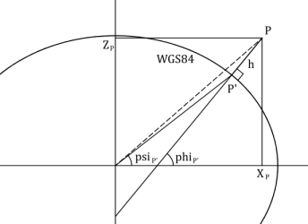
Imagine a point P in the y=0 plane, geocentric and geodetic latitudes over the WGS84 ellipsoid may be represented as follows:

1

Note the following problem: The geocentric latitude must be calculated for P', the orthogonal projection of P over the ellipsoid surface. But the angle obtained by ATAN(z/x) is for the dashed line instead.

The formula provided by R. Rapp in that part of the book is for points that belong to the ellipsoid surface, and can't be used with the coordinates of points far away from it.


How can you know if the point belongs to the ellipsoid surface? Verify if your coordinates satisface the oblated ellipsoid equation:

x^2/a^2 + y^2/a^2 + z^2/b^2 = 1

How can you eliminate this? Well, perform the "complicated" calculation.

3
  • This one is great! Thanks. You absolutely found the point which was missing: The higher latitude is not orthogonal to the surrounding ellipsoid. :) I learned something. Great!
    – S-Man
    Commented Mar 24, 2020 at 9:26
  • 1
    S-Man you are welcome. I updated my answer to what I consider is more correct. Previous answer is also valid, but this way of looking at the problem seems more appropriate to me. Commented Mar 24, 2020 at 11:58
  • Do you have good recommendation for an algorithm to take? It should work highlich precise for many different h (near the ground, very high), but can be somewhat slower (precision better than calculation time). Or would you take one for near ground (what is near ground? 10m? 100m? what about -10m?) and another for higher (maybe lower?) h?
    – S-Man
    Commented Mar 25, 2020 at 11:32

Your Answer

By clicking “Post Your Answer”, you agree to our terms of service and acknowledge you have read our privacy policy.

Not the answer you're looking for? Browse other questions tagged or ask your own question.