4

I want to show Features in QGIS taking account of three different factors. These are for wind farms and I want to show:

  1. The height of the turbines (eg. up to 100m, 100-150m, 150-200m & over 200m - using differnt symbols - circle, triangle, etc);
  2. The stage of development (eg. operational, under constuction, approved awaiting construction & seeking approaval - probably with different colours);
  3. The overall size of the WF (up to 100MW, 100-200MW, 200-300MW etc - probably by the size of the symbol).

Is this do-able? What's the easiest way to do it?

1
  • 1
    I think this question is clear and focused enough to be reopened. It does not ask three different questions, but how to achieve a combined symbology, based on three conditions.
    – Babel
    Commented Sep 13, 2021 at 13:11

1 Answer 1

2

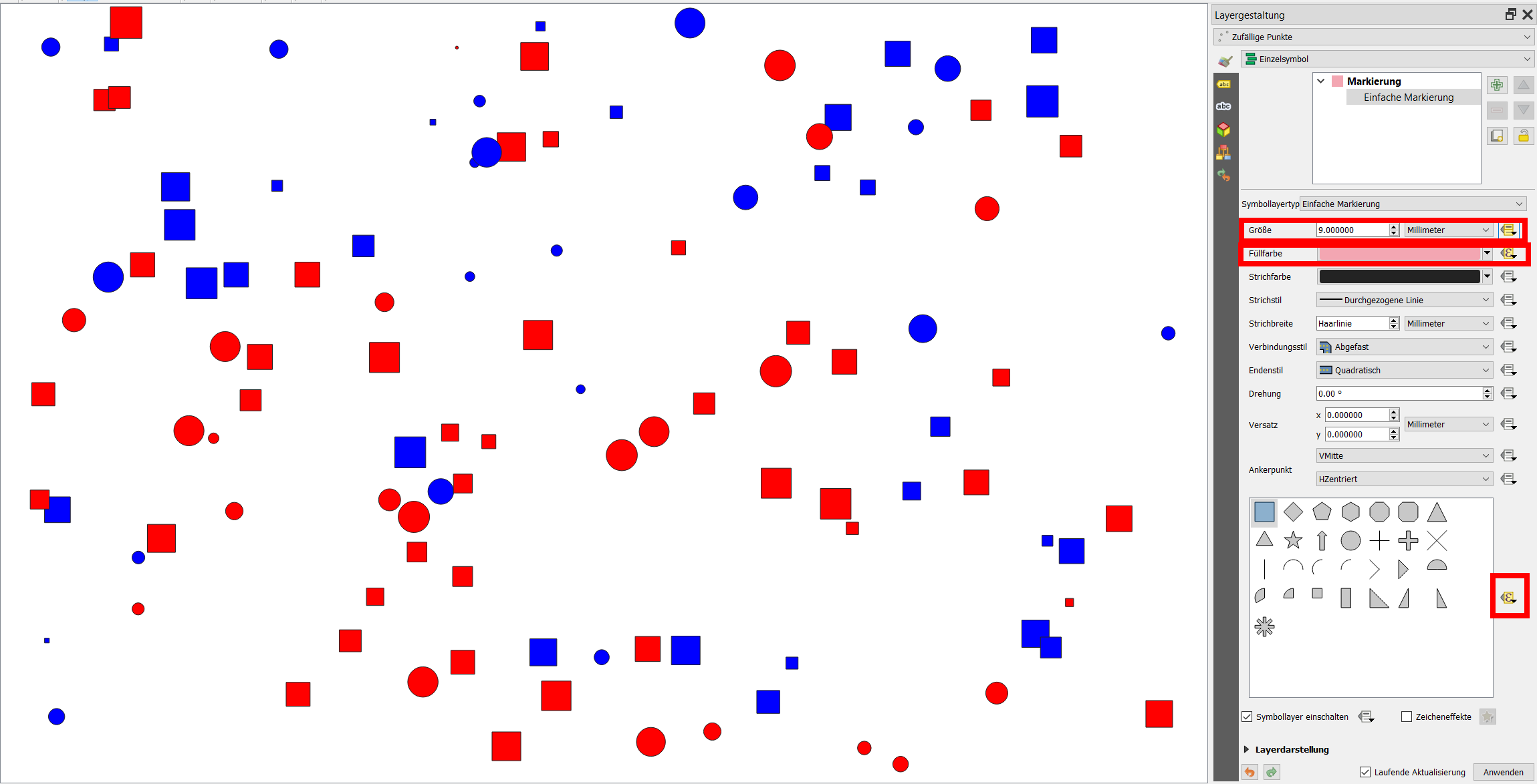
You can set the three conditions separately and use data driven override (Epsilon symbol: ε) on the right sight of the entries for size, color and symbol shape in the symbolization:

  1. For shape, use an expression like:

     case 
     when floor ("hight"/100)>3 then 'square' else 'circle'
     end
    
  2. For stage of development, use data driven override and set an expression like:

     case 
     when stage=  'operational' then 'red' 
     when stage=  'under construction' then 'blue'
     end
    
  3. For size, use data driven override and use assistant, based on the field size.

enter image description here

4
  • For conditions with only true/false it is better to use if
    – Taras
    Commented Sep 9, 2021 at 16:53
  • Of course! But the question suggests that there are more categories (not true/fasle). To make things a bit shorter, I opted to just create two conditions that can be expanded on the pattern presented, so it is just for demonstration.
    – Babel
    Commented Sep 9, 2021 at 18:20
  • Thanks Babel. You have provided me with sufficient guidance to be able to achieve what I require. I appreciate more categories are required. I don't really understand why the question was closed - while others may not like the question, I feel it's a valid question.
    – ChrisF
    Commented Sep 13, 2021 at 12:59
  • I don't know why exactly the question was closed, seems to be OK to me. Sometimes it helps to post a screenshot to show how the result should look like. By the way: this side tries to avoid "thank you" messages. Instead, it encourages you to accept the answer if it solved your problem and/or upvote it: click the checkmark right to the answer to accept it - see: gis.stackexchange.com/help/someone-answers
    – Babel
    Commented Sep 13, 2021 at 13:09

Your Answer

By clicking “Post Your Answer”, you agree to our terms of service and acknowledge you have read our privacy policy.

Not the answer you're looking for? Browse other questions tagged or ask your own question.