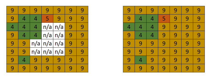
I'm reclassifying a DEM asset into 6 categories. However, there are some pixels that don't meet my criteria and are null. I would like to find a way to fill these gaps depending on its area and its neighbor's values.
My current workflow is the following:
- Get the inverse mask
- Clump pixels
- Identify groups that met the area criteria
- Apply a morphological max filter (10 iterations) within the masked area, and
- Add bands and reduce by the max category.
Although my code is working and it's doing what I want, it is causing memory issues when working with bigger areas and with a high-res scale. I've been seen that the most memory-consuming step is the morphological filter and the 10 fixed iterations sometimes are not enough to fill all the gaps, is there an alternative to do this?.
A code snippet can be found here:
https://code.earthengine.google.com/4ad5be8fd16607a589bd54858af0edd6
var test_image = ee.Image("users/dfgm2006/categorical_ranges");
// Fill gaps using the surrounding pixels

var inverse = test_image.unmask().not().eq(1).selfMask()


var connected = inverse.connectedComponents({
  connectedness: ee.Kernel.plus(1),
  maxSize: 128
})
var connected_size = connected.select([connected.bandNames().get(0)])
  .connectedPixelCount({
    maxSize: 128,
    eightConnected: false
})

var connected_area = ee.Image.pixelArea()
                              .addBands(connected_size)
                              .lte(25000000)
                              .eq(1)
                              .selfMask()
                              .select('labels')

var fill = test_image.focalMax( 1,'square','pixels',10)
                            .updateMask(connected_area)
                            .selfMask()

var filled = test_image.addBands(fill)
  .reduce(ee.Reducer.max()).regexpRename('max','constant')


Map.addLayer(test_image.randomVisualizer())
Map.addLayer(filled.randomVisualizer())
This is the expected result.

