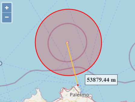
The distance between Ustica Island and the coast of Palermo is about 54 thousand meters. I expect that by constructing a Circle like this new ol.geom.Circle(centerInMapProjection, 53708); to see the perimeter of the circle touch the coast. Yet the circle is much smaller. What am I doing wrong?
Here is a working snippet with OpenLayers 3. It also has the measurement system built in.
<!DOCTYPE html>
<html lang="en">
<head>
    <meta charset="UTF-8">
    <title>OpenLayers Circle and Geodetic Measurement</title>
    <link rel="stylesheet" href="https://openlayers.org/en/v3.20.1/css/ol.css" type="text/css">
    <style>
        #map {
            width: 100%;
            height: 100vh;
        }
        .ol-tooltip {
            background-color: white;
            border: 1px solid black;
            padding: 4px;
            position: absolute;
            white-space: nowrap;
        }
        .ol-tooltip-measure {
            opacity: 0.7;
            font-weight: bold;
        }
    </style>
</head>
<body>
    <div id="map" class="map"></div>
    <script src="https://openlayers.org/en/v3.20.1/build/ol.js"></script>
    <script>
        var map = new ol.Map({
            target: 'map',
            layers: [
                new ol.layer.Tile({
                    source: new ol.source.OSM()
                })
            ],
            view: new ol.View({
                center: [1468335.0056440544, 4680137.027803559],
                zoom: 7
            })
        });

        function addCircle(x, y, radiusInMeters) {
            var centerInMapProjection = [x, y];

            var circleGeometry = new ol.geom.Circle(centerInMapProjection, radiusInMeters);

            var circleFeature = new ol.Feature(circleGeometry);

            var vectorSource = new ol.source.Vector({
                features: [circleFeature]
            });

            var vectorLayer = new ol.layer.Vector({
                source: vectorSource,
                style: new ol.style.Style({
                    stroke: new ol.style.Stroke({
                        color: 'red',
                        width: 2
                    }),
                    fill: new ol.style.Fill({
                        color: 'rgba(255, 0, 0, 0.2)'
                    })
                })
            });

            map.addLayer(vectorLayer);
        }

        addCircle(1468335.0056440544, 4680137.027803559, 53708);

        var measureSource = new ol.source.Vector();

        var measureLayer = new ol.layer.Vector({
            source: measureSource,
            style: new ol.style.Style({
                fill: new ol.style.Fill({
                    color: 'rgba(255, 255, 255, 0.2)'
                }),
                stroke: new ol.style.Stroke({
                    color: '#ffcc33',
                    width: 2
                }),
                image: new ol.style.Circle({
                    radius: 7,
                    fill: new ol.style.Fill({
                        color: '#ffcc33'
                    })
                })
            })
        });

        map.addLayer(measureLayer);

        var draw = new ol.interaction.Draw({
            source: measureSource,
            type: 'LineString',
            style: new ol.style.Style({
                fill: new ol.style.Fill({
                    color: 'rgba(255, 255, 255, 0.2)'
                }),
                stroke: new ol.style.Stroke({
                    color: 'rgba(0, 0, 0, 0.5)',
                    lineDash: [10, 10],
                    width: 2
                }),
                image: new ol.style.Circle({
                    radius: 5,
                    stroke: new ol.style.Stroke({
                        color: 'rgba(0, 0, 0, 0.7)'
                    }),
                    fill: new ol.style.Fill({
                        color: 'rgba(255, 255, 255, 0.2)'
                    })
                })
            })
        });
        map.addInteraction(draw);

        var measureTooltipElement = document.createElement('div');
        measureTooltipElement.className = 'ol-tooltip ol-tooltip-measure';
        var measureTooltip = new ol.Overlay({
            element: measureTooltipElement,
            offset: [0, -15],
            positioning: 'bottom-center'
        });
        map.addOverlay(measureTooltip);

        var formatLength = function(line) {
            var wgs84Sphere = new ol.Sphere(6378137);
            var coordinates = line.getCoordinates();
            var length = 0;
            var sourceProj = map.getView().getProjection();
            for (var i = 0, ii = coordinates.length - 1; i < ii; ++i) {
                var c1 = ol.proj.transform(coordinates[i], sourceProj, 'EPSG:4326');
                var c2 = ol.proj.transform(coordinates[i + 1], sourceProj, 'EPSG:4326');
                length += wgs84Sphere.haversineDistance(c1, c2);
            }
            var output;
            /*if (length > 100) {
                output = (Math.round(length / 1000 * 100) / 100) + ' km';
            } else {*/
                output = (Math.round(length * 100) / 100) + ' m';
            //}
            return output;
        };

        draw.on('drawstart', function(evt) {
            measureSource.clear();
            var tooltipCoord = evt.coordinate;
            evt.feature.getGeometry().on('change', function(evt) {
                var geom = evt.target;
                var output = formatLength(geom);
                tooltipCoord = geom.getLastCoordinate();
                measureTooltipElement.innerHTML = output;
                measureTooltip.setPosition(tooltipCoord);
            });
        });

        draw.on('drawend', function() {
            measureTooltipElement = null;
            createMeasureTooltip();
        });

        function createMeasureTooltip() {
            measureTooltipElement = document.createElement('div');
            measureTooltipElement.className = 'ol-tooltip ol-tooltip-measure';
            measureTooltip = new ol.Overlay({
                element: measureTooltipElement,
                offset: [20, -25],
                positioning: 'bottom-center'
            });
            map.addOverlay(measureTooltip);
        }

        createMeasureTooltip();
    </script>
</body>
</html>
