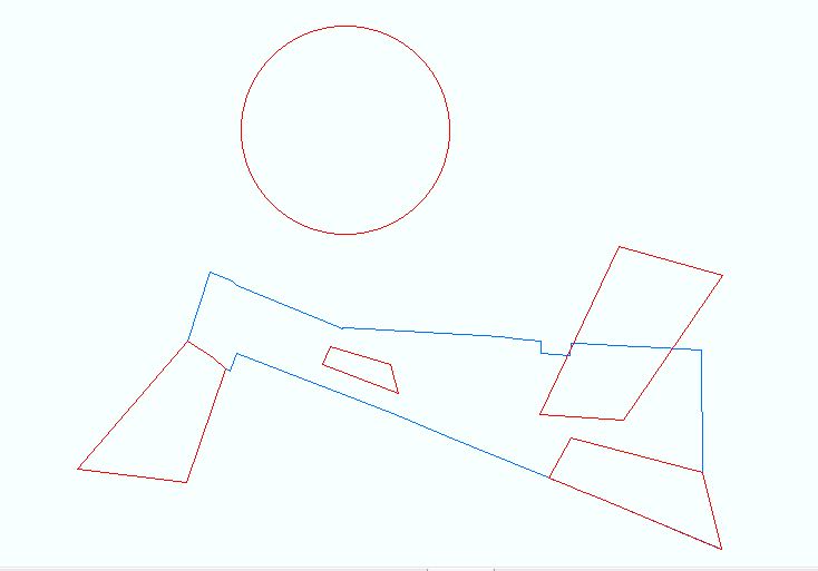
I want to go through each red feature and test it against the blue layer(which will contain multiple features). The tests to carry out for each feature are:
- Wholly Outside
- Wholly outside but with a touching boundary
- Crosses
- Wholly inside but common boundary
- Encloses
- Wholly inside with no touching boundary
I have written the following code protected override void OnClick() {
        genericFunctions generic = new genericFunctions();
        IDataset StopUpDS = generic.getDatasets("suTest");
        IDataset HighwaysDS = generic.getDatasets("highwaysTest");


        //create featureclass for the stop up object
        IFeatureLayer StopUpFL = (IFeatureLayer)StopUpDS;
        IFeatureClass StopUpFC = StopUpFL.FeatureClass;

        //create featureclass for the highways object
        IFeatureLayer highwaysFL = (IFeatureLayer)HighwaysDS;
        IFeatureClass highwaysFC = highwaysFL.FeatureClass;


        IFeatureCursor StopUpCur = StopUpFC.Search(null, true);
        IFeature stopUpFeature = StopUpCur.NextFeature();


        while (stopUpFeature != null)
        {
            //zoom to feature
            IEnvelope env = stopUpFeature.Extent.Envelope;
            env.Expand(2.0, 2.0, true);
            mxdoc.ActiveView.Extent = env;
            mxdoc.ActiveView.Refresh();

            MessageBox.Show("");
            spatialVal(stopUpFeature, StopUpFC, highwaysFC, "****T****", "SHARES A BOUNDARY"); // SHARES A BOUNDARY

            //spatialVal(stopUpFeature, StopUpFC, highwaysFC, "F***F****", "WHOLLY OUTSIDE"); // WHOLLY OUTSIDE

            //spatialVal(stopUpFeature, StopUpFC, highwaysFC, "FFFFFFFF*", "WHOLLY OUTSIDE"); // WHOLLY OUTSIDE
            //spatialVal(stopUpFeature, StopUpFC, highwaysFC, "FF*FF****", "WHOLLY OUTSIDE"); // WHOLLY OUTSIDE
            //spatialVal(stopUpFeature, StopUpFC, highwaysFC, "F**F****", "DO NOT INTERSECT"); // DO NOT INTERSECT
            //spatialVal(stopUpFeature, StopUpFC, highwaysFC, "FFFTTTTTT", "WHOLLY OUTSIDE"); // WHOLLY OUTSIDE
            //spatialVal(stopUpFeature, StopUpFC, highwaysFC, "FFFFTFFF*", "WHOLLY OUTSIDE BUT COMMON BOUNDARY"); // WHOLLY OUTSIDE BUT COMMON BOUNDARY
            //spatialVal(stopUpFeature, StopUpFC, highwaysFC, "F***T****", "WHOLLY OUTSIDE BUT COMMON BOUNDARY"); // WHOLLY OUTSIDE BUT COMMON BOUNDARY
            //spatialVal(stopUpFeature, StopUpFC, highwaysFC, "TT*T*****", "CROSSES"); // CROSSES
            //spatialVal(stopUpFeature, StopUpFC, highwaysFC, "T***T****", "CROSSES"); // CROSSES
            //spatialVal(stopUpFeature, StopUpFC, highwaysFC, "T***T****", "WHOLLY INSIDE BUT COMMON BOUNDARY"); // WHOLLY INSIDE BUT COMMON BOUNDARY
            //spatialVal(stopUpFeature, StopUpFC, highwaysFC, "T***T****", "WHOLLY INSIDE BUT COMMON BOUNDARY"); // WHOLLY INSIDE BUT COMMON BOUNDARY
            //spatialVal(stopUpFeature, StopUpFC, highwaysFC, "T*T******","ENCLOSES" ); // ENCLOSES
            //spatialVal(stopUpFeature, StopUpFC, highwaysFC, "T*****T**", "WHAT WE NEED"); // WHAT WE NEED

            //spatialVal(stopUpFeature, StopUpFC, highwaysFC, "*********", "WHAT WE NEED"); // EVERYTHING SHOULD COME UP ONCE ONLY, WHICH IS DOES!!!!!


            stopUpFeature = StopUpCur.NextFeature();
        }

    }

    public void spatialVal(IFeature inFeature,IFeatureClass inFC,  IFeatureClass highwaysFC, string spatialDesc, string spatialTestType)
    {
        ISpatialFilter spaFil = new SpatialFilterClass();
        spaFil.Geometry = inFeature.Shape;
        spaFil.GeometryField =  highwaysFC.ShapeFieldName;
        spaFil.SpatialRel = esriSpatialRelEnum.esriSpatialRelRelation;
        //spaFil.SpatialRel = esriSpatialRelEnum.esriSpatialRelWithin;
        spaFil.SpatialRelDescription = spatialDesc;

        //query the results from the spatial filter

        IFeatureCursor geomCursor = inFC.Search(spaFil, true);
        IFeature geomFeat = geomCursor.NextFeature();
        while (geomFeat != null)
        {
            DialogResult result = MessageBox.Show("WARNING! would you like to continue?", spatialTestType, MessageBoxButtons.YesNo, MessageBoxIcon.Warning, MessageBoxDefaultButton.Button1);
            if (result == DialogResult.No)
            {
                MessageBox.Show("You will need to fix the polygon before you can move it");
            }
            geomFeat = geomCursor.NextFeature();
        }
        mxdoc.ActiveView.Refresh();
    }
The problem that I am getting is that no matter what spatialDescription I am using, it always loops through each feature, for example using spatialVal(stopUpFeature, StopUpFC, highwaysFC, "****T****", "SHARES A BOUNDARY"); it will still show the warning message for the outer most polygon (the circle) even though it does not share a boundary with the blue layer
it is also showing the warning message for the feature that is wholly in the blue area, but the boundary do not match.
I posted a similar'ish question as Spatial relationships that do not match, but i think this is a different problem, hence a new question.

