Does anyone know of any good sources for US data (counties, congressional districts, etc) in GeoJSON format? Has anyone converted public-domain shapefiles/sources to GeoJSON that they would be willing to share?
-
2If you acquire the datasets there's always the possibility to converted them yourself through ogr2ogr utility in the GDAL library or with QGIS (which uses the GDAL library).– Pedro MendesCommented Dec 29, 2011 at 11:43
-
@PedroMendes Thanks for the suggestion. That is why I've been doing. I was just curious if there was a more comprehensive source for US data.– CaseyCommented Dec 29, 2011 at 16:30
-
Not much US data but I was super happy to find geojson.xyz, since they have a simple index of a wide variety of data sources, all hosted on Cloudfront with CORS headers so I can test out my application on a bunch of primitive types.– CodererCommented Jan 28, 2019 at 15:16
7 Answers
I found something closer to what I was looking for (US State and County boundaries) on github: https://github.com/johan/world.geo.json/tree/master/countries/USA
The features are very generalized/simplified, but they'll work for a national scale map. Country boundaries for the whole world are available in this repo too.
After trying to find similar GeoJSON versions of US State and County boundaries, I finally decided to roll my own from the United States Census Cartographic Boundary Files, converting them to GeoJSON and KML formats using the MyGeoData vector converter.
I've made the results of this conversion available at: https://eric.clst.org/tech/usgeojson/. Feel free to use these if they will help.
-
1Was using these, gratefully, but just noticed that California districts are not accurate for 113th Congress. For instance, in eric.clst.org/wupl/Stuff/gz_2010_us_500_11_20m.json look in the northern part of the state. Not sure of accuracy other states. Commented Nov 18, 2013 at 18:07
-
@MarjorieRoswell, can you tell whether the source data was the issue, or is there a problem with only the JSON?– EFCCommented Nov 19, 2013 at 15:10
-
I just downloaded, unzipped, and checked gz_2010_us_050_00_20m.zip: It's using the older districts, too. Here's what CA should look like for the current congress: nationalatlas.gov/printable/printableViewer.htm?imgF=images/… Commented Nov 19, 2013 at 17:29
-
1Thanks for pointing this out, Marjorie. I'm not surprised that redistricting is not fully reflected in these 2010 files. But it is good to be alert about this lag.– EFCCommented Nov 20, 2013 at 18:31
-
1Use TIGER2013 to get the congressional districts (and state legislative districts) as they were redrawn after the 2010 census. www2.census.gov/geo/tiger/TIGER2013 Commented Jul 15, 2014 at 14:16
I've translated most of the Census Cartography files to GeoJSON for your convenience:
You might take a look at SimpleGeo’s CC0 Places data set, and this related question: Converting SimpleGeo Places GeoJSON file to shapefile?
or just searching the geojson tag may turn up some results for you.
-
January 12th, 2012: After SimpleGeo was acquired by Urban Airship in Oct 2011, Urban Aiship said “wind down the availability of the current versions of [SimpleGeo's] Places, Context, and Storage over the next few months.”...The target date for pulling the plug officially will be March 31, 2012. Link Commented Feb 7, 2013 at 18:43
If you're on linux, try converting .shp files downloaded directly from the census website to geoJSON data using the gdal command line tool. For Debian/Ubuntu that means installing the gdal-bin package, and then running a command like this one:
ogr2ogr -f GeoJSON cb_2018_us_cbsa_20m.json cb_2018_us_cbsa_20m.shp
Disclaimer, I work for this company
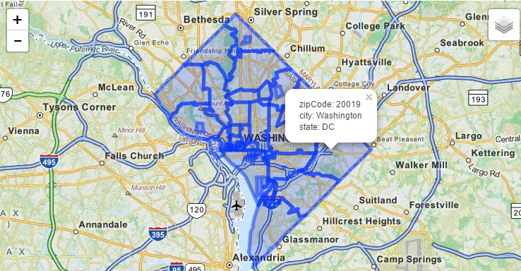
you can get US Zipcode Boundaries(qurey by city,state,or county) via this api API:
https://boundaries-io.com
the API shows US Boundaries(GeoJson) by zipcode,city, and state. you should use the API programatically to handle large results.
the image is query by state(DC)..gives you all zipcodes in DC.
-
This uses TIGER2013, and can query for multiple counties,cities,states,zipcodes for aggregate GeoJson responses. Commented Jun 3, 2015 at 12:16
Try using Freebase API. For example the following article
http://www.freebase.com/view/en/orange_county
Available in JSON:
http://www.freebase.com/experimental/topic/standard/en/orange_county
