There are two options to get to the underlying data on ArcGIS Server from QGIS.
You indicate you would prefer a local copy, so I will cover that first, but I will briefly touch on connecting to the REST endpoint as well.
Before you do any of this, please make sure it's OK to do so. I don't see an express license statement for the data on that server. I would contact the owner and see what the license is and what you're allowed to do with their data.
Local Copy:
I would recommend that you look into the Bolton & Menk GIS Team ArcGIS REST API. It can be found on Github at https://github.com/Bolton-and-Menk-GIS/restapi
There are other similar tools available, but many of them rely on ESRI software to do their work. In fact, ESRI themselves have similar tool.
This is a Python module that lets you interact with many aspects of ArcGIS Server. One example shown in the readme is how to save a copy of a Feature Service to a shapefile or KMZ. This works either with proprietery ESRI tools if they are installed and licensed, or otherwise it will use open source tools for this.
So for this purpose you would define the server url:
rest_url = 'http://tps.geosur.info/arcgis/rest/services'
ags = restapi.ArcServer(rest_url)
Then you can use the various sample script in the readme and
For example, define the MapService you want to work with:
GeoSUR_SPHydropower = ags.get_MapService('GeoSUR_SPHydropower')
and view the layers it contains:
print GeoSUR_SPHydropower.list_layers()
You can also see these listed on the MapService page: http://tps.geosur.info/arcgis/rest/services/maps/GeoSUR_SPHydropower/MapServer
To save the data locally, you would have to download each layer individually and save it to shapefile. For example:
lyr = GeoSUR_SPHydropower.layer('Regionalized Basins')
output = r'c:\path\to\shapefile.shp'
lyr.layer_to_fc(output)
As you can see, you could easily automate downloading of all the layers with the list_layers method.
Live connection in QGIS:
There is an experimental QGIS Plugin available to do just this with an ArcGIS Server REST service.
To install it, go to Plugins - Manage and install plugins..., then go to Settings, and check "Show also experimental plugins". At the bottom, click "Reload repository" and go back to the "All" tab. Now search for ArcGIS REST API Connector and install it. A new icon will appear in your Manage Layers toolbar:
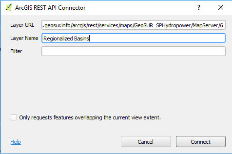
 Click it and paste a layer URL into the first field, Layer URL. The second field, Layer Name, should populate automatically.
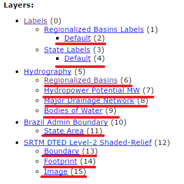
You need to put a layer URL here, and only certain types of layers are supported. You can't use a Group Layer (one that contains multiple other layers). If you look on the service page, the layers are shown in a nested way. Layers you can use are always the ones on the lowest respective level:

The ones underlined in red are ones you can probably use, although I'm not sure if the Labels ones are the image layers are supported.
To add the layer, just right-click it's name in that list and copy the url, then paste it in the Layer URL field.


