0

I had a quick look of the other questions about hydrology using a DEM (SAGA/ArGIS) and I guess I need to calculate something different from a traditional flow accumulation/channel network/catchment basins for an hydrological model.

I'm working with pipe network systems and when the capacity of system is over, the water is coming out from a single or more manholes. What about the water, where is going?

The manhole is a single point in a DEM, is there an easy tool to try to assess the most probable flow path of the water over the DEM? (Without calculate the stream network for the whole DEM until accidentally a stream cross the manhole)

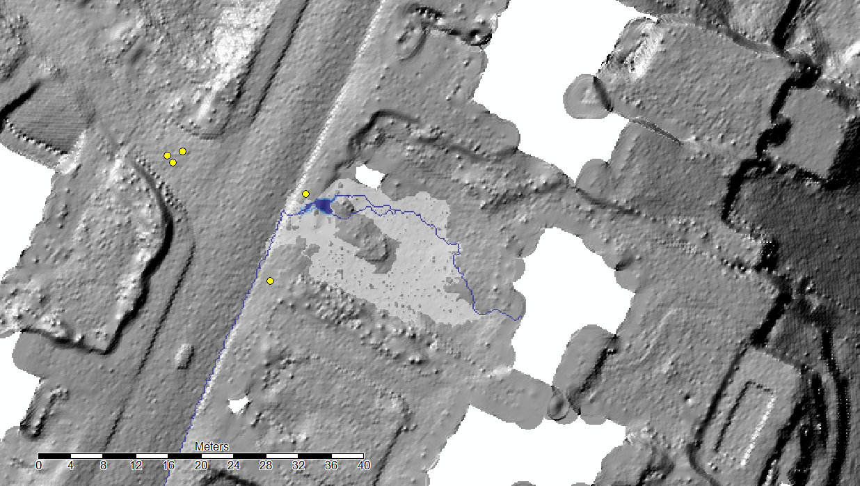
I'm mainly using SAGA and ArcGIS. I read and tried most of the tools in Saga (SAGA - Tools - Hydrology) but none seems to be what I'm looking for. They are all trying to calculate a channel network for the whole DEM when I need just a line from a point as output. The only one useful is the Downslope Area but it is interactive (I have to select the starting point with the mouse). The not interactive version seems to be released in a new version of SAGA (Feature Request -SAGA).

Downslope Area (Method MDF) with SAGA; the yellow points are the manholes

My questions are:

  • Are there similar tools in SAGA?
  • Is there a way to start the Downslope Area from many different points?
  • Is there a similar tool in ArcGIS?
1
  • What GIS software are you actually using and want to ask about? Once you've decided that you'll be much better positioned to describe not just what you want to do but what you have tried and where you are stuck.
    – PolyGeo
    Commented Nov 2, 2017 at 9:22

1 Answer 1

1

"The most probable flow path of the water over the DEM" is still the output of a common drainage network as the one obtained with r.stream.extract with an elevation map and optional accumulation map as input. See: Methodology for creating accurate drainage networks (and catchments) from high resolution LiDAR DEM?

Your case is the "Test 8B" of this research project : https://www.gov.uk/government/publications/benchmarking-the-latest-generation-of-2d-hydraulic-flood-modelling-packages

You will need hydraulic modelling capabilities which are far beyond a normal GIS software.

6
  • Thank you very much for your answer! I know I should use an 2D hydraulic modeling and that is why I wrote "most probable path": I do not need to be 100% sure, just to have an idea in order to decide if a 2D modeling is necessary Commented Nov 2, 2017 at 9:47
  • I was looking for something like this (SAGA - Downslope Area): sagatutorials.wordpress.com/… Commented Nov 2, 2017 at 10:42
  • If you’re using ArcGIS and have the Spatial Analyst extension, Cost Path can be used to assess where flow originating from a source point (your manhole cover) would flow according to a DEM surface. Use your DEM as the Input Cost Raster and the output of the Flow Direction tool as the Input Backlink Raster.
    – Jae
    Commented Nov 2, 2017 at 11:55
  • From my experience the whole process should be doable using Saga and considering only the area you're interested in as a drainage Basin. And the multiple downslope is possible too if you import a shapefile with the points you want to consider in your analysis. Other idea that could work: Use the SAGA tools to create your drainage Bassin for the whole map, then only extract the ones that are on the area you're focusing on. You will always have to work on something at LEAST slightly bigger than what you want to keep in the end. Commented Nov 3, 2017 at 9:40
  • Thank you for you comment. What you suggest (considering the area as drainage basin and than extract from the channel network the only channel I need) it is exactly what I would like to avoid. I just want to know the most likely paths/streams from my points without calculating the whole dem (or a part of that) Commented Nov 3, 2017 at 13:01

Not the answer you're looking for? Browse other questions tagged or ask your own question.