2

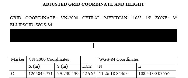
I was provided the coordinates of a site in Vietnam in VN-2000 grid coordinate, central meridian: 108 15 zone: 3 degrees, ellipsiod: WGS84

Plotting the WGS84 coordinates (see attached image) in Google Earth resulted to the relatively correct location. However, when I tried adding the data to ArcMap using Add XY Data and the VN-2000 coordinates, the points were plotted way way east somewhere in Malaysia.

What is the proper way of plotting the points in VN-2000 given the information above?

enter image description here

2
  • 1
    ArcGIS doesn't have a VN-2000 projected crs that matches a 108.25 central meridian. I do think it has a false easting of 500000 m and that the X and Y columns are actually X = northing (Y in the software) and Y = easting (X in software). That gets me within a few hundred meters.
    – mkennedy
    Commented Jan 12, 2018 at 19:07
  • 1
    Even adding a geographic/datum transformation isn't working. Add the two sets separately (convert the DMS to decimal degrees). When you use Add XY data, make sure you set the WGS84 coordinate system for the DD data. For the VN2000 data, leave the coordinate system undefined. Try setting the data frame's coordinate system to the custom one and set the geographic transformation as well. Then you can see how far off they are.
    – mkennedy
    Commented Jan 12, 2018 at 19:10

1 Answer 1

1

As commented by @mkennedy:

ArcGIS doesn't have a VN-2000 projected crs that matches a 108.25 central meridian. I do think it has a false easting of 500000 m and that the X and Y columns are actually X = northing (Y in the software) and Y = easting (X in software). That gets me within a few hundred meters.

and:

Even adding a geographic/datum transformation isn't working. Add the two sets separately (convert the DMS to decimal degrees). When you use Add XY data, make sure you set the WGS84 coordinate system for the DD data. For the VN2000 data, leave the coordinate system undefined. Try setting the data frame's coordinate system to the custom one and set the geographic transformation as well. Then you can see how far off they are.

Your Answer

By clicking “Post Your Answer”, you agree to our terms of service and acknowledge you have read our privacy policy.

Not the answer you're looking for? Browse other questions tagged or ask your own question.