1

I am having GPS and SFM (Structure for motion) trajectory in UTM coordinates. I wanted to convert the both trajectory to NED (North East Down).

Method 1

In First step: I converted the data from UTM ---> Lat, Long, Height

In second step: Lat, Long, Height ----> NED.

Method 2:

As another method I took the first data from SFM in UTM coordinate as reference. Then I subtracted the first data [easting, northing, height] from all other points. So, I got the data in meters.

The same data point [easting, northing, height] again subtracted from GPS data points. The GPS data is in now meters.

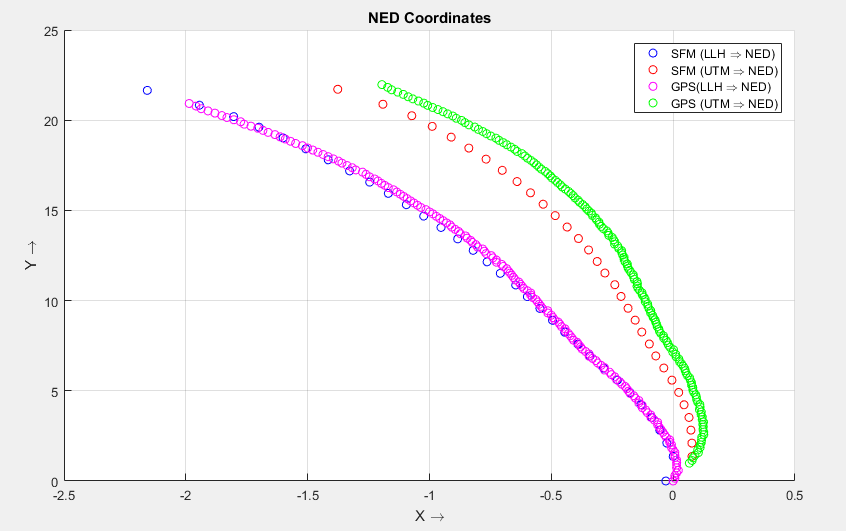
The plots looks as following:

enter image description here

Which method is correct for conversion of data to NED?

Because method 2 data is matching what the plot should look like in UTM!

Whereas method 1 might have precision problem due to two conversions, that's why the both data are close and seems overlapping each other. But that is not the case with original data.

What is the best method to convert UTM to NED frame?

0

1 Answer 1

1

I agree with everything @FSimardGIS commented:

The UTM grid north does not match True North except on the central meridian and Equator. There can be a difference of a few degrees. (This is called Grid Convergence) Moreover, UTM being a Projected Coordinate System, you will have distance distortions if you use those coordinates (although quite small within 3° of central meridian). And the Z (Down) coordinate will be wrong with UTM because it wouldn't take into account the curvature of the Earth.

It also depends on what precision you are aiming. For example in chile (37° south), in worst case I have 3cm distortion every 100m. Too much for surveying. You can also transform: UTM >> geographic >> ECEF >> NED

Your Answer

By clicking “Post Your Answer”, you agree to our terms of service and acknowledge you have read our privacy policy.

Not the answer you're looking for? Browse other questions tagged or ask your own question.