1

Is there anyone who can explain the difference between ol.proj.getPointResolution() and ol.sphere.getDistance()?

I have tested it, and ol.sphere.getDistance() is a little bit shorter than ol.proj.getPointResolution(). In addition, I corrected the lengths by elevations with the Pythagoras. Below an GPX example file.

Why is with "sphere" shortener? "sphere" calculate with a radius and not the direct distance, logical there must be greater. ??? The same difference exists everywhere on the map, also much further north, eg in Europe.

Only getLength(): 1322.334212854104

getLength() with pythagorean(): 1322.4583239930157

ol.proj.getPointResolution(): 1322.3120192140298

ol.proj.getPointResolution() with pythagorean(): 1322.436132435775

ol.sphere.getDistance(): 1320.834204523846

ol.sphere.getDistance() with pythagorean(): 1320.9584565960345

GPX Example (near equador) from brouter.de

<?xml version="1.0" encoding="UTF-8"?>
<!-- track-length = 1323 filtered ascend = 0 plain-ascend = -1 cost=4036 energy=.0kwh time=9.9m -->
<gpx 
 xmlns="http://www.topografix.com/GPX/1/1" 
 xmlns:xsi="http://www.w3.org/2001/XMLSchema-instance" 
 xsi:schemaLocation="http://www.topografix.com/GPX/1/1 http://www.topografix.com/GPX/1/1/gpx.xsd" 
 creator="BRouter-1.4.11" version="1.1">
 <trk>
  <name>brouter_trekking_0</name>
  <trkseg>
   <trkpt lon="11.487967" lat="0.332443"><ele>319.0</ele></trkpt>
   <trkpt lon="11.488969" lat="0.332369"><ele>318.0</ele></trkpt>
   <trkpt lon="11.494446" lat="0.331905"><ele>309.0</ele></trkpt>
   <trkpt lon="11.499806" lat="0.331473"><ele>317.0</ele></trkpt>
  </trkseg>
 </trk>
</gpx>

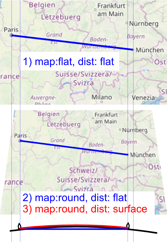
Example what i mean:

enter image description here

1) is simple length() between two coords. (longest).
2) the earth is round, but a direct distance is "through" the earth. (shortest).
3) the earth is round and the distance is on the earths surface. (best).

TEST:

Result (single-calculation sum, in meter):

Near Equator short distance (4 points), manually set elevation (350,100,0,300):

brouter (inside GPX file) = 1323

ol.proj.getPointResolution() = 1322.3120192140298
ol.proj.getPointResolution() + pythagorean() = 1563.4324417597672

ol.sphere.getDistance() = 1320.834204523846
ol.sphere.getDistance() + pythagorean() = 1562.1085409935195

distVincenty() = 1322.2532472090315
distVincenty() + pythagorean() = 1563.379164847775


Near Equator long distance, 440 meter elevation range (min,max):

brouter (inside GPX file) = 385356

ol.proj.getPointResolution() = 384026.1115163949
ol.proj.getPointResolution() + pythagorean() = 384353.99178101047

ol.sphere.getDistance() = 383596.9242847851
ol.sphere.getDistance() + pythagorean() = 383925.16964882094

distVincenty() = 383079.99691655475
distVincenty() + pythagorean() = 383408.65056785266


Europe near Pyrenees long distance, 430 meter elevation range (min,max):

brouter (inside GPX file) = 144047

ol.proj.getPointResolution() = 142398.39352352163
ol.proj.getPointResolution() + pythagorean() = 142514.5599121801

ol.sphere.getDistance() = 142239.2492071166
ol.sphere.getDistance() + pythagorean() = 142355.53984053037

distVincenty() = 142463.4265797505
distVincenty() + pythagorean() = 142579.5329685958


Fazit: The joke is, the first was i notice, that the ol.proj.getPointResolution() is shorter than brouter. Than i test ol.sphere.getDistance(), and this was more shorter. Last i test distVincenty(), and this was once shorter and some longer than the other (Equator shorter, Europe longer), but shorter as brouter. Logical would be for me, though the ol.proj.getPointResolution() was the shortest and the distVincenty() was the longest. Does anyone have an explanation for that?

2 Answers 2

2

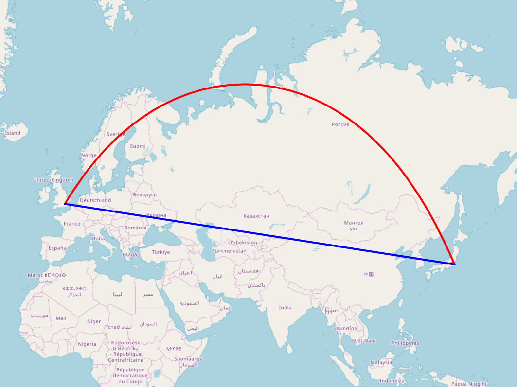
Sphere gives the shortest distance on a spherical planet. What appears to be a straight line on a flat map isn't the shortest distance that an aircraft would fly, especially over long distances such as London to Tokyo

enter image description here

distVincenty = function(p1, p2) {
    var ct = {
        a: 6378137,
        b: 6356752.3142,
        f: 1/298.257223563
    };
    var a = ct.a, b = ct.b, f = ct.f;

    var L = (p2.lon - p1.lon) * Math.PI/180;
    var U1 = Math.atan((1-f) * Math.tan(p1.lat*Math.PI/180));
    var U2 = Math.atan((1-f) * Math.tan(p2.lat*Math.PI/180));
    var sinU1 = Math.sin(U1), cosU1 = Math.cos(U1);
    var sinU2 = Math.sin(U2), cosU2 = Math.cos(U2);
    var lambda = L, lambdaP = 2*Math.PI;
    var iterLimit = 20;
    while (Math.abs(lambda-lambdaP) > 1e-12 && --iterLimit>0) {
        var sinLambda = Math.sin(lambda), cosLambda = Math.cos(lambda);
        var sinSigma = Math.sqrt((cosU2*sinLambda) * (cosU2*sinLambda) +
        (cosU1*sinU2-sinU1*cosU2*cosLambda) * (cosU1*sinU2-sinU1*cosU2*cosLambda));
        if (sinSigma==0) {
            return 0;  // co-incident points
        }
        var cosSigma = sinU1*sinU2 + cosU1*cosU2*cosLambda;
        var sigma = Math.atan2(sinSigma, cosSigma);
        var alpha = Math.asin(cosU1 * cosU2 * sinLambda / sinSigma);
        var cosSqAlpha = Math.cos(alpha) * Math.cos(alpha);
        var cos2SigmaM = cosSigma - 2*sinU1*sinU2/cosSqAlpha;
        var C = f/16*cosSqAlpha*(4+f*(4-3*cosSqAlpha));
        lambdaP = lambda;
        lambda = L + (1-C) * f * Math.sin(alpha) *
        (sigma + C*sinSigma*(cos2SigmaM+C*cosSigma*(-1+2*cos2SigmaM*cos2SigmaM)));
    }
    if (iterLimit==0) {
        return NaN;  // formula failed to converge
    }
    var uSq = cosSqAlpha * (a*a - b*b) / (b*b);
    var A = 1 + uSq/16384*(4096+uSq*(-768+uSq*(320-175*uSq)));
    var B = uSq/1024 * (256+uSq*(-128+uSq*(74-47*uSq)));
    var deltaSigma = B*sinSigma*(cos2SigmaM+B/4*(cosSigma*(-1+2*cos2SigmaM*cos2SigmaM)-
        B/6*cos2SigmaM*(-3+4*sinSigma*sinSigma)*(-3+4*cos2SigmaM*cos2SigmaM)));
    var s = b*A*(sigma-deltaSigma);
    var d = s.toFixed(3)/1000; // round to 1mm precision
    return d;
};
5
  • Yes, that's logical. But, my example is very short and at the equator. How do you explain that? With longer routes, up to 150 km in Europe, it is just like that. I can not drive "through" the globe, but I have to drive on the earth's surface, thats a longer way.
    – Suka
    Commented Apr 12, 2019 at 23:27
  • Is "sphere" only for longer distances and "PointRes" more for short distances?
    – Suka
    Commented Apr 13, 2019 at 0:03
  • Flat projections are generally not suitable for long distances. EPSG:3857 is based on the Earth's equatorial radius of 6378137 meters. ol.sphere uses the Earth's average radius of 6371008.8 meters. So right on the equator EPSG:3857 would be more accurate than ol.sphere. A transverse mercator projection such as UTM would be good if your route closely folowed a meridian. If you need extra precise calculation you need the Vincenty ellipsoid method which uses both the equatorial and polar radii.
    – Mike
    Commented Apr 13, 2019 at 10:03
  • Oh wow, what a function! i understand not realy what, but a little bit. I have added a example picture on my question above. Please read to understand what i mean, and than please answer me whether the functions result is point 3 (red).
    – Suka
    Commented Apr 14, 2019 at 19:10
  • Please see my answer for more details. Your example is close to the equator but not following the circle of latitude. Commented Sep 22, 2022 at 15:26
0

A point has no dimension hence the resolution will be for the latitude only.

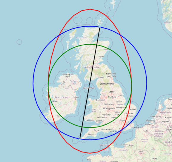
Imagine a straight line from John O Groats to Land's End. The spherical distance will be about 968km.

A point created by evenly splitting the latitude and longitude of the two locations will be a little bit off the straight line. This point would sit on the great circle.

The green circle is drawn on the halfway point with a radius of 484km.

The red circle is created by creating a polygon from the circle and transforming that polygon geometry from web mercator (epsg:3857) to epsg:4326. You can see that the radius is equal at the same latitude but increases along the longitude.

https://codepen.io/dbauszus-glx/pen/LYmjZvP

enter image description here

Your Answer

By clicking “Post Your Answer”, you agree to our terms of service and acknowledge you have read our privacy policy.

Not the answer you're looking for? Browse other questions tagged or ask your own question.