1

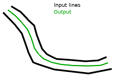
I have a dataset of pairs of parallel linear features (railway tracks) and I need to simplify each pair into its central/median line. This could be achieved by computing a skeleton as suggested in this question but I am looking for a simpler solution: a line being the "average" of the two input lines would be a fair approximation. For example:

enter image description here

Would such transformation be implemented in any mainstream GIS software or library?

1

1 Answer 1

1

There is an ArcGIS tool called Collapse Dual Lines to Center line that will accomplish this task. The tool requires and Advanced ArcGIS license. Here is a link to the tools help for 10.x

GRASS also has a tool called v.Centerline that will work in both GRASS or via the GRASS tools in QGIS. Here is a link to the GRASS tool.

Your Answer

By clicking “Post Your Answer”, you agree to our terms of service and acknowledge you have read our privacy policy.

Not the answer you're looking for? Browse other questions tagged or ask your own question.