1

I am trying to create an app which consumes data from http://apigobiernoabiertortod.valencia.es/apirtod/datos/intensidad_tramos.json.

The JSON files offer the coordinates for me. However, I cannot figure out what are the latitude and longitude of these coordinates. I only know that the coordinates are located in the Valencia city (Spain), but when I use this site to convert the coordinates it is pointing to a different location.

I searched a little bit and I have discovered that there is a lot of types of conversions. How do I know the correct formula to convert these raw coordinate values?

4
  • 1
    If the publisher of the coordinates has not specified what coordinate system he is using, you can only find out by trial and error. I suggest you download qgis and import one of those coordinates as a point and then change the crs by right click until you got the right one. as georeference I propose an openstreetmap basemap via the open layers plugin.
    – Leo
    Commented Jul 23, 2019 at 8:35
  • 3
    @Leo projfinder.com speeds up that guessing process by a factor of about a zillion!
    – Spacedman
    Commented Jul 23, 2019 at 8:37
  • 1
    @Spacedman learned something new - thanks!
    – Leo
    Commented Jul 23, 2019 at 8:38
  • @Spacedman, thanks, me too!
    – Taras
    Commented Jul 23, 2019 at 8:55

1 Answer 1

3

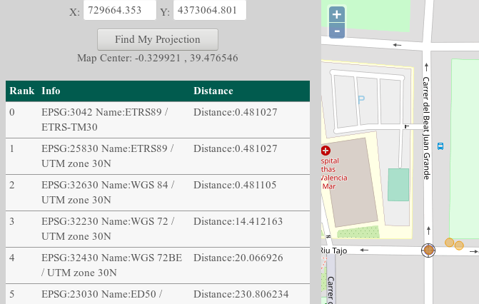
I used projfinder.com - put one of your X and Y coordinates in the coordinate boxes, zoom and centre the map to where the points should be, and hit "find my projection". I'm guessing your point should be on this road junction:

example

There are three projections that are all about the same distance from that road junction and nothing closer, so the chances are its one of those. I'd go for the UTM Zone 30N/WGS84 one since its the most usual thing one sees in projections. UTM zones are commonly used for mapping small parts of the earth:

EPSG:32630 Name:WGS 84 / UTM zone 30N

Now you know the EPSG code (32630) you need to find software that can convert between projections or coordinate reference systems. This will depend on your application, but you probably want to use a library that interfaces with the PROJ system.

2
  • there might be something wrong with this site. I copy the same location that you searched and when I hit "find my projection" button it does not show the EPSG:32630 and neither a location in Spain. It is showing someplace in the USA. The map center is also different of your screen shot.
    – Felipe
    Commented Jul 23, 2019 at 8:54
  • thanks. the second site worked!
    – Felipe
    Commented Jul 23, 2019 at 9:03

Your Answer

By clicking “Post Your Answer”, you agree to our terms of service and acknowledge you have read our privacy policy.

Not the answer you're looking for? Browse other questions tagged or ask your own question.