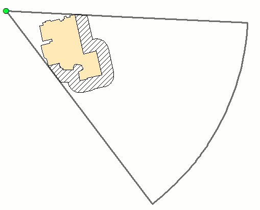
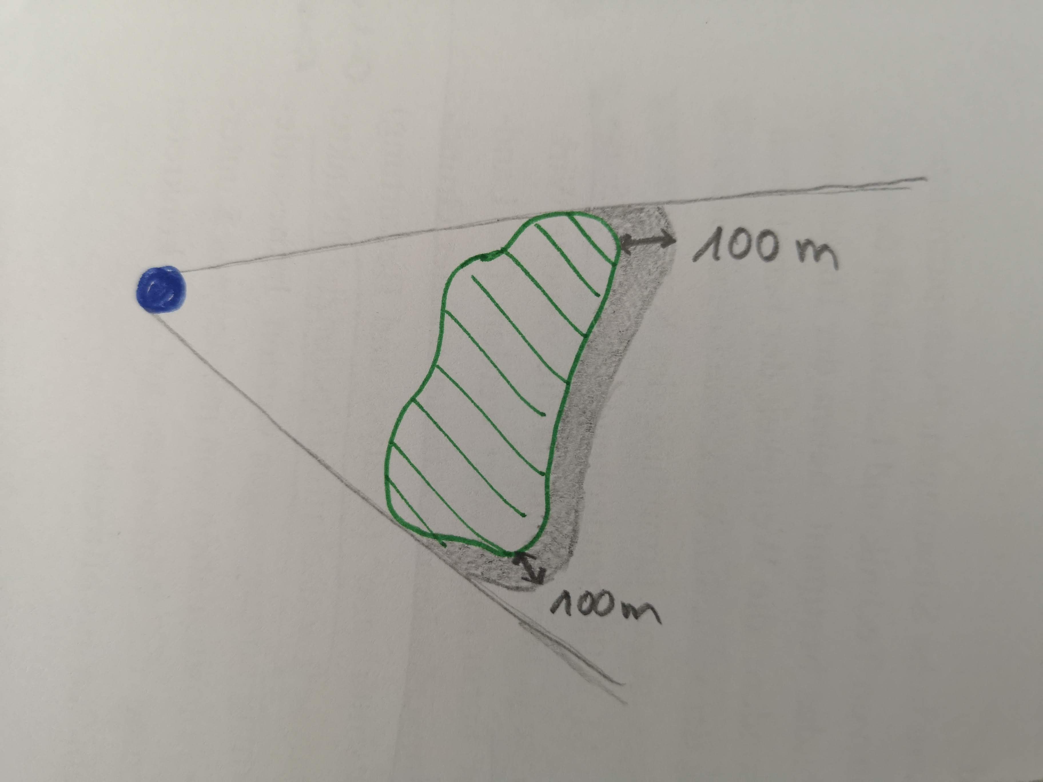
Yes it is much more straightforward with advanced license using near, erase, points to line etc. tools. Anyway the workflow below will work with basic license and it is a good candidate for model builder. Shouldn't be hard to shuffle through 100 polygons. It honors selection:
# find script to convert all building vertces to points
arcpy.FeatureVerticesToPoints_management(in_features="BUILDING", out_feature_class="C:/SCRATCH/ALL_POINTS.shp", point_location="ALL")
arcpy.AddGeometryAttributes_management(Input_Features="VIEW_POINT", Geometry_Properties="POINT_X_Y_Z_M", Length_Unit="", Area_Unit="", Coordinate_System="")
arcpy.SpatialJoin_analysis(target_features="ALL_POINTS", join_features="VIEW_POINT", out_feature_class="C:/SCRATCH/SJ.shp", join_operation="JOIN_ONE_TO_ONE", join_type="KEEP_ALL", field_mapping='GISBUILDIN "GISBUILDIN" true true false 10 Long 0 10 ,First,#,ALL_POINTS,GISBUILDIN,-1,-1;ORIG_FID "ORIG_FID" true true false 10 Long 0 10 ,First,#,ALL_POINTS,ORIG_FID,-1,-1;GISBUILDIN_1 "GISBUILDIN_1" true true false 10 Long 0 10 ,First,#,VIEW_POINT,GISBUILDIN,-1,-1;POINT_X "POINT_X" true true false 19 Double 0 0 ,First,#,VIEW_POINT,POINT_X,-1,-1;POINT_Y "POINT_Y" true true false 19 Double 0 0 ,First,#,VIEW_POINT,POINT_Y,-1,-1', match_option="CLOSEST", search_radius="", distance_field_name="Distance")
# add fields to store view points coordinates
arcpy.AddField_management(in_table="SJ", field_name="NEW_X", field_type="DOUBLE", field_precision="", field_scale="", field_length="", field_alias="", field_is_nullable="NULLABLE", field_is_required="NON_REQUIRED", field_domain="")
arcpy.AddField_management(in_table="SJ", field_name="NEW_Y", field_type="DOUBLE", field_precision="", field_scale="", field_length="", field_alias="", field_is_nullable="NULLABLE", field_is_required="NON_REQUIRED", field_domain="")
arcpy.CalculateField_management(in_table="SJ", field="NEW_X", expression="[POINT_X]", expression_type="VB", code_block="")
arcpy.CalculateField_management(in_table="SJ", field="NEW_Y", expression="[POINT_Y]", expression_type="VB", code_block="")
# find end points coordinates and extend future line to 1000 m from view point
arcpy.AddGeometryAttributes_management(Input_Features="SJ", Geometry_Properties="POINT_X_Y_Z_M", Length_Unit="", Area_Unit="", Coordinate_System="")
arcpy.CalculateField_management(in_table="SJ", field="POINT_X", expression="[NEW_X]+( [POINT_X]- [NEW_X])/ [Distance]*1000", expression_type="VB", code_block="")
arcpy.CalculateField_management(in_table="SJ", field="POINT_Y", expression="[NEW_Y]+( [POINT_Y]- [NEW_Y])/ [Distance]*1000", expression_type="VB", code_block="")
arcpy.XYToLine_management(in_table="SJ", out_featureclass="C:/SCRATCH/RAYS.shp", startx_field="NEW_X", starty_field="NEW_Y", endx_field="POINT_X", endy_field="POINT_Y", line_type="GEODESIC", id_field="", spatial_reference="PROJCS['NZGD_2000_New_Zealand_Transverse_Mercator',GEOGCS['GCS_NZGD_2000',DATUM['D_NZGD_2000',SPHEROID['GRS_1980',6378137.0,298.257222101]],PRIMEM['Greenwich',0.0],UNIT['Degree',0.0174532925199433]],PROJECTION['Transverse_Mercator'],PARAMETER['False_Easting',1600000.0],PARAMETER['False_Northing',10000000.0],PARAMETER['Central_Meridian',173.0],PARAMETER['Scale_Factor',0.9996],PARAMETER['Latitude_Of_Origin',0.0],UNIT['Meter',1.0]];-4020900 1900 450445547.391054;-100000 10000;-100000 10000;0.001;0.001;0.001;IsHighPrecision")
# buffer (with dissolve) 1000 m rays and create their convex hull to produce sector
arcpy.Buffer_analysis(in_features="RAYS", out_feature_class="C:/SCRATCH/BUFFER.shp", buffer_distance_or_field="1 Meters", line_side="FULL", line_end_type="ROUND", dissolve_option="ALL", dissolve_field="", method="PLANAR")
# line below is the only "arcpy" expression
arcpy.CalculateField_management(in_table="BUFFER", field="Shape", expression="!Shape!.convexHull()", expression_type="PYTHON_9.3", code_block="")
arcpy.Buffer_analysis(in_features="BUFFER", out_feature_class="C:/SCRATCH/SECTOR.shp", buffer_distance_or_field="-1 Meters", line_side="FULL", line_end_type="ROUND", dissolve_option="NONE", dissolve_field="", method="PLANAR")
# intersect bulding buffer with sector and find shadow
arcpy.Intersect_analysis(in_features="BUFF_50M #;SECTOR #", out_feature_class="C:/SCRATCH/ISECT.shp", join_attributes="ALL", cluster_tolerance="-1 Unknown", output_type="INPUT")
arcpy.Union_analysis(in_features="ISECT #;BUILDING #", out_feature_class="C:/SCRATCH/SCRATCH.gdb/ISECT_Union", join_attributes="ALL", cluster_tolerance="", gaps="GAPS")
arcpy.SelectLayerByLocation_management(in_layer="ISECT_Union", overlap_type="ARE_IDENTICAL_TO", select_features="BUILDING", search_distance="", selection_type="NEW_SELECTION", invert_spatial_relationship="INVERT")
arcpy.MultipartToSinglepart_management(in_features="ISECT_Union", out_feature_class="C:/SCRATCH/SCRATCH.gdb/SPARTS")
arcpy.Sort_management(in_dataset="SPARTS", out_dataset="C:/SCRATCH/SORTED.shp", sort_field="Shape_Area DESCENDING", spatial_sort_method="UR")
arcpy.SelectLayerByAttribute_management(in_layer_or_view="SORTED", selection_type="NEW_SELECTION", where_clause='"FID" >0')
arcpy.DeleteFeatures_management(in_features="SORTED")


