4

I have been trying to understand how to implement the LRS plugin but there are many things that does not "click" in my head. Not sure if it is the terminology or the process i dont understand, please help with some pointers of what I am missing.

I have been through the documentation and I have been reading these two posts already, but I think there is something fundamental I am missing for my understanding to tie the dots together. If someone have sample data or a video showing the complete process that would be of interest.
Linear Referencing in QGIS?
How to find Chainage of points using QGIS

I will try to be concise and clear of what i ask.. I have far too many stupid questions on this as I am a bit at loss..

If I start from scratch with a topological correct road network that has a field road_number. Several road segments with the same road_number make up a complete road. Say I have a point layer with street signs, what do i need to do to reference them to the network?

As a test I created a point layer and placed a placed a few points close to the line. Each point has an attribute that is the same as the closest route. enter image description here
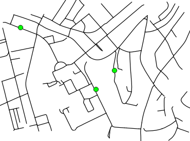
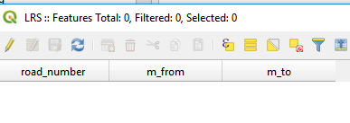
Assuming the first thing i should do is to calibrate it. My output layer I get has 3 columns road_number, m_from, m_to but is completely empty? Am I missing something?enter image description here
2
  • Got a few steps further myself. I created a point layer with 2 fields "measure" and route_number. I add the measure values "by hand" (measure at start and en point for each line route), i kind of expected this to be able to be created for us. I am sure it can be automated though. But after creating the point layer I could go ahead using the plugin functionality.
    – geogrow
    Commented Nov 26, 2019 at 10:42
  • You may have a look at this PDF (it's for ArcMap but the concept are the same and it could help you to better understand what and how to do ) : help.arcgis.com/en/arcgisdesktop/10.0/pdf/…
    – J.R
    Commented Nov 26, 2019 at 12:09

2 Answers 2

3

The first question you have to ask yourself is "Is linear referencing the solution I need to solve my downstream problems?"

Road networks are notorious for being difficult linear networks to work with (cul-de-sacs/duel carriages/overpasses/multi-level highways/slip lanes etc), so attempting to setup a standard naming and dissolved set of data may be difficult.

From a solution perspective, what advantage does '27m from Intersection' give you? Think about this in context of your road sign example. Maintenance crews are probably going to use modern GIS on mobile device map to 'find' the assets, so what advantage does the chainage give?

The opposing solution would be to simply store the data as geometry, with topology rules that link it to the road.

The argument FOR using linear referencing may be made when the position of assets is on a singular long road. (eg: A highway) The chainage is going to be '12.1km' from origin. These situations may be more appropriate for linear referencing, particularly in regional areas.

1

You need to set first and last point to calibrate the path along which you want to plot the points, QChainage does the trick - just click the right box in the popup window.

The table with the point distance needs to have reference to the path one.

I found this video "Create Points Along Route at Specified Distance - QGIS - LRS" on YT very useful

1
  • Link-only answers are often deleted. Linkless link-mostly answers could have the same fate. When it comes to Answers, more details are better.
    – Vince
    Commented Oct 20, 2021 at 18:13

Your Answer

By clicking “Post Your Answer”, you agree to our terms of service and acknowledge you have read our privacy policy.

Not the answer you're looking for? Browse other questions tagged or ask your own question.