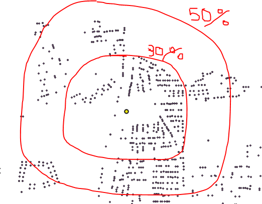
You could create a Virtual Layer with the following query:
WITH distances AS(
  SELECT
    b.fid b_fid,
    a.fid a_fid,
    ST_Distance(b.geometry,a.geometry) dist
  FROM layer_B b
  CROSS JOIN layer_A a
),
percentiles AS(
  SELECT
    b_fid,
    a_fid,
    dist,
    NTILE(10) OVER(
      PARTITION BY b_fid
      ORDER BY dist)*10 percentile
  FROM distances
),
radii AS(
  SELECT
    b_fid,
    percentile,
    MAX(dist) radius
  FROM percentiles
  GROUP BY b_fid, percentile
)
--SELECT * FROM distances;
--SELECT * FROM percentiles;
--SELECT * FROM radii;
-- to debug, comment the following lines and uncomment the previous clause of interest
SELECT
  r.b_fid,
  r.percentile,
  r.radius,
  ST_Buffer(b.geometry,r.radius) geom
FROM layer_B b
INNER JOIN radii r
ON b.fid = r.b_fid
WHERE
  (r.percentile = 20
  OR r.percentile = 30
  OR r.percentile = 50);
The previous query will work for one or more features in layer_B.
We are creating a table (distances) with all distances from all points in layer B to all points in layer A.
Then, we are creating a table (percentiles) with 10 groups of distances for each point in layer B.
Next, we are creatting the radii table selecting the maximum distance from each group of percentiles.
Finally, we are creating a buffer for each point in layer B and each radius of radii table, but filtering them to only those with percentiles 20, 30 and 50.
Notes:
I am assuming the layer_A and layer_B names of the source layers. Also, I am assuming fid and geometry field names (GeoPackage defaults). Replace that names in the query to match your layer and field names.
A virtual layer is stored in the project and is dinamically updated every time a source layer change. Export it to a file if features in source layers will not change.

