1

I've got two rasters, soil and slope. I want to plot the slope raster but only in areas where there is soil (i.e. soil is > 0). How can I do this?

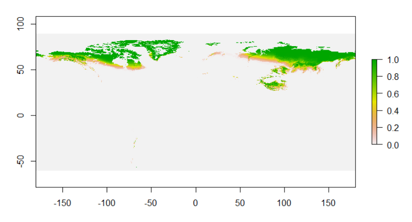
This is the soil raster:

enter image description here

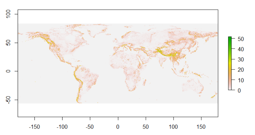
This is the slope raster: enter image description here

EDIT 1: more information about the rasters.

soil

 > extent(soil)
 class      : Extent 
 xmin       : -180 
 xmax       : 179.9856 
 ymin       : -60 
 ymax       : 89.994 
 > res(soil)
 [1] 0.008333 0.008333
 > origin(soil)
 [1]  0.001133 -0.002400  

slope

 > extent(slope)
class      : Extent 
xmin       : -180 
xmax       : 180.0023 
ymin       : -56.00016 
ymax       : 84.00257 
> res(slope)
[1] 0.008333386 0.008333496
> origin(slope)
[1] 0.0011330 0.0009332

EDIT 2: information about dimensions

 > dim(soil)
 [1] 18000 43200     1

 > dim(slope)
 [1] 16800 43200     1
8
  • The two rasters have the same extent. Do you mean you want the slope where the soil raster is not zero? Does zero define your idea of where "soil" isnt?
    – Spacedman
    Commented Mar 26, 2020 at 15:46
  • Hi! Yes, exactly. I need to create a graph showing slope only in areas where soil is greater than 0.
    – jimyeti
    Commented Mar 26, 2020 at 15:55
  • a graph or a map?
    – Spacedman
    Commented Mar 26, 2020 at 16:01
  • A map! Sorry :)
    – jimyeti
    Commented Mar 26, 2020 at 16:01
  • do the rasters have the same resolution, extent, and origin? Show the summary of each raster if not.
    – Spacedman
    Commented Mar 26, 2020 at 16:01

1 Answer 1

0
require(raster)

# make 2 dummy rasters, different extents but same origin and resolution. Values 1:6
slope <- raster(xmn = 0, xmx = 5, ymn = 0, ymx = 5, res = 1)
slope[] <- sample(1:6, ncell(slope), replace = T)

soil <- raster(xmn = 0, xmx = 7, ymn = -1, ymx = 4, res = 1)
soil[] <- sample(1:6, ncell(soil), replace = T)

# create your blank raster to populate. This is only the area both inputs occupy.
r_intersec <- raster(raster::intersect(slope,soil))

# The other 2 rasters should be cropped to the extent of your target raster, to avoid extent errors as mentioned in the comments
croped_slope <- crop(slope,extent(r_intersec))
croped_soil <- crop(soil,extent(r_intersec))

tmp <- croped_slope
tmp[which(croped_soil[] <= 0)] <- NA

par(mfrow=c(1,3))
plot(slope)
plot(soil)
plot(tmp)

*raster sample and crop idea from https://gis.stackexchange.com/a/328883/77836

5
  • This will only work if the rasters overlap perfectly, which they don't when you look at the description in the question.
    – Spacedman
    Commented Mar 26, 2020 at 19:46
  • @Spacedman Yes, sorry. I believe I fixed it.
    – MarujoRe
    Commented Mar 26, 2020 at 20:52
  • Hi @MarujoRe thanks for your help! When I run your code on my R it throws me an error at the step to create blank raster to populate: unable to find an inherited method for function ‘raster’ for signature ‘"integer"’. Not sure why?
    – jimyeti
    Commented Mar 27, 2020 at 13:32
  • 2
    Does running raster::intersect(slope,soil)) solve the issue? This specifies that intersect from the raster package is to be used, in case other packages with functions of the same name is masking the one you want to use.
    – humperderp
    Commented Mar 27, 2020 at 14:15
  • Yep, works now! Thank you @humperderp
    – jimyeti
    Commented Mar 27, 2020 at 16:54

Your Answer

By clicking “Post Your Answer”, you agree to our terms of service and acknowledge you have read our privacy policy.

Not the answer you're looking for? Browse other questions tagged or ask your own question.