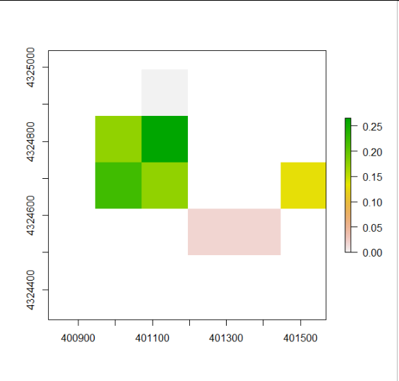
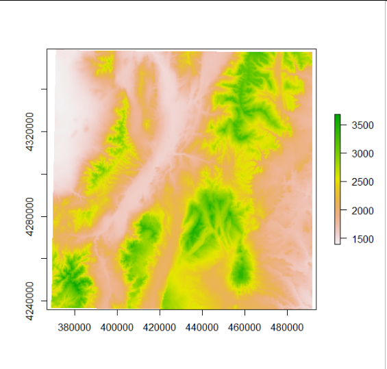
I have two raster layers that I would like to create a raster stack from. They are currently in different extents. One is a DEM layer and the other is a raster of an individual's home range. This is the DEM layer that I currently have:
> str(elev_med)
Formal class 'RasterLayer' [package "raster"] with 12 slots
  ..@ file    :Formal class '.RasterFile' [package "raster"] with 13 slots
  .. .. ..@ name        : chr "C:\\Users\\jhnhn\\AppData\\Local\\Temp\\RtmpaOErZT\\file4f03b9d4e7b.tif"
  .. .. ..@ datanotation: chr "INT2S"
  .. .. ..@ byteorder   : chr "little"
  .. .. ..@ nodatavalue : num -Inf
  .. .. ..@ NAchanged   : logi FALSE
  .. .. ..@ nbands      : int 1
  .. .. ..@ bandorder   : chr "BIL"
  .. .. ..@ offset      : int 0
  .. .. ..@ toptobottom : logi TRUE
  .. .. ..@ blockrows   : int 3
  .. .. ..@ blockcols   : int 1039
  .. .. ..@ driver      : chr "gdal"
  .. .. ..@ open        : logi FALSE
  ..@ data    :Formal class '.SingleLayerData' [package "raster"] with 13 slots
  .. .. ..@ values    : logi(0)
  .. .. ..@ offset    : num 0
  .. .. ..@ gain      : num 1
  .. .. ..@ inmemory  : logi FALSE
  .. .. ..@ fromdisk  : logi TRUE
  .. .. ..@ isfactor  : logi FALSE
  .. .. ..@ attributes: list()
  .. .. ..@ haveminmax: logi TRUE
  .. .. ..@ min       : num -32768
  .. .. ..@ max       : num 32767
  .. .. ..@ band      : int 1
  .. .. ..@ unit      : chr ""
  .. .. ..@ names     : chr "file4f03b9d4e7b"
  ..@ legend  :Formal class '.RasterLegend' [package "raster"] with 5 slots
  .. .. ..@ type      : chr(0)
  .. .. ..@ values    : logi(0)
  .. .. ..@ color     : logi(0)
  .. .. ..@ names     : logi(0)
  .. .. ..@ colortable: logi(0)
  ..@ title   : chr(0)
  ..@ extent  :Formal class 'Extent' [package "raster"] with 4 slots
  .. .. ..@ xmin: num 368790
  .. .. ..@ xmax: num 491929
  .. .. ..@ ymin: num 4236172
  .. .. ..@ ymax: num 4358719
  ..@ rotated : logi FALSE
  ..@ rotation:Formal class '.Rotation' [package "raster"] with 2 slots
  .. .. ..@ geotrans: num(0)
  .. .. ..@ transfun:function ()
  ..@ ncols   : int 1039
  ..@ nrows   : int 1034
  ..@ crs     :Formal class 'CRS' [package "sp"] with 1 slot
  .. .. ..@ projargs: chr "+proj=utm +zone=12 +datum=WGS84 +units=m +no_defs"
  .. .. ..$ comment: chr "PROJCRS[\"WGS 84 / UTM zone 12N\",\n    BASEGEOGCRS[\"WGS 84\",\n        DATUM[\"World Geodetic System 1984\",\"| __truncated__
  ..@ history : list()
  ..@ z       : list()
and this is the home range raster that I have:

> str(sum_raster[[1]])
Formal class 'RasterLayer' [package "raster"] with 12 slots
  ..@ file    :Formal class '.RasterFile' [package "raster"] with 13 slots
  .. .. ..@ name        : chr ""
  .. .. ..@ datanotation: chr "FLT4S"
  .. .. ..@ byteorder   : chr "little"
  .. .. ..@ nodatavalue : num -Inf
  .. .. ..@ NAchanged   : logi FALSE
  .. .. ..@ nbands      : int 1
  .. .. ..@ bandorder   : chr "BIL"
  .. .. ..@ offset      : int 0
  .. .. ..@ toptobottom : logi TRUE
  .. .. ..@ blockrows   : int 0
  .. .. ..@ blockcols   : int 0
  .. .. ..@ driver      : chr ""
  .. .. ..@ open        : logi FALSE
  ..@ data    :Formal class '.SingleLayerData' [package "raster"] with 13 slots
  .. .. ..@ values    : num [1:30] NA NA 0 NA NA ...
  .. .. ..@ offset    : num 0
  .. .. ..@ gain      : num 1
  .. .. ..@ inmemory  : logi TRUE
  .. .. ..@ fromdisk  : logi FALSE
  .. .. ..@ isfactor  : logi FALSE
  .. .. ..@ attributes: list()
  .. .. ..@ haveminmax: logi TRUE
  .. .. ..@ min       : num 0
  .. .. ..@ max       : num 0.266
  .. .. ..@ band      : int 1
  .. .. ..@ unit      : chr ""
  .. .. ..@ names     : chr "layer"
  ..@ legend  :Formal class '.RasterLegend' [package "raster"] with 5 slots
  .. .. ..@ type      : chr(0)
  .. .. ..@ values    : logi(0)
  .. .. ..@ color     : logi(0)
  .. .. ..@ names     : logi(0)
  .. .. ..@ colortable: logi(0)
  ..@ title   : chr(0)
  ..@ extent  :Formal class 'Extent' [package "raster"] with 4 slots
  .. .. ..@ xmin: num 400820
  .. .. ..@ xmax: num 401570
  .. .. ..@ ymin: num 4324369
  .. .. ..@ ymax: num 4324994
  ..@ rotated : logi FALSE
  ..@ rotation:Formal class '.Rotation' [package "raster"] with 2 slots
  .. .. ..@ geotrans: num(0)
  .. .. ..@ transfun:function ()
  ..@ ncols   : int 6
  ..@ nrows   : int 5
  ..@ crs     :Formal class 'CRS' [package "sp"] with 1 slot
  .. .. ..@ projargs: chr "+proj=utm +zone=12 +datum=WGS84 +units=m +no_defs"
  .. .. ..$ comment: chr "PROJCRS[\"WGS 84 / UTM zone 12N\",\n    BASEGEOGCRS[\"WGS 84\",\n        DATUM[\"World Geodetic System 1984\",\"| __truncated__
  ..@ history : list()
  ..@ z       : list()
I tried cropping the data:
# Load packages
library(elevatr)
library(sp)
library(raster)

# Download elevation data based on the home range isopleth
elev_med <- get_elev_raster(sum_iso[[1]], z = 9)

#Plot elevation raster
plot(elev_med)

#Crop elevation raster to home range raster
et <- crop(elev_med, sum_raster[[1]])

plot(sum_raster[[1]])
plot(et)

# Create raster stack
rs <- raster::stack(sum_raster[[1]], et)
I continue to get the error stating that they have different extents. What would be the best way to approach this?


raster::res(x)to check the resolution of each data. You can then resample to the desired resolution.