3

I have a project where I have Polygons drawn in a Openlayers map. These objects get turned into GeojSON using format.writeGeometry(plot.geometry.getGeometry()). This is my first project using a PostGIS database in combination with OpenLayers and GeoJSON.

Then I send them to a NodeJS backend who then sends this data to a PostGIS database. 'INSERT INTO plots (user_id, geog) VALUES ($1, ST_GeomFromGeoJSON($2))'. Where the geog is the Geojson that I receive from the frontend.

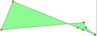
The problem that I am facing is that the coordinates get distorted inside the Database. This is an example of how the coordinates are represented inside the database:

enter image description here

Here is the Geojson from the above example that is being inserted into the Database:

{
   "type":"Polygon",
   "coordinates":[
      [
         [
            352847.7681741,
            6591493.68325289
         ],
         [
            352853.14118403,
            6591495.88702873
         ],
         [
            352865.86122686,
            6591501.10405905
         ],
         [
            352866.13573636,
            6591501.21660883
         ],
         [
            352866.14658836,
            6591501.22104384
         ],
         [
            352856.32964058,
            6591526.19583173
         ],
         [
            352854.06390643,
            6591531.95998212
         ],
         [
            352853.92222987,
            6591531.90191122
         ],
         [
            352766.24950317,
            6591495.94284857
         ],
         [
            352766.18921573,
            6591495.91814133
         ],
         [
            352778.56476466,
            6591465.29940885
         ],
         [
            352847.7681741,
            6591493.68325289
         ]
      ]
   ]
}

And the polygon that is being generated in the PostGIS database:

SRID=4326;POLYGON((47.76817410002695 -73.68325288966298,53.14118402998429 -75.88702872954309,65.86122686002636 -81.10405904985964,66.13573635998182 -81.21660882979631,66.14658836001763 -81.2210438400507,56.32964057999197 -73.80416826996952,54.06390642997576 -68.04001787956804,53.92222986998968 -68.09808878041804,-33.75049682997633 -75.94284856971353,-33.81078426999738 -75.91814132966101,-21.43523533997359 -45.29940885026008,47.76817410002695 -73.68325288966298))

12
  • 3
    seems to be a SRID issue. whats the SRID in the frontend?
    – ziggy
    Commented Jul 1, 2021 at 15:22
  • @ziggy The SRID I use in the frontend is EPSG:3857.
    – Stephen
    Commented Jul 1, 2021 at 15:28
  • 2
    Use format.writeGeometry(plot.geometry.getGeometry(), {dataProjection: 'EPSG:4326', 'featureProjection': 'EPSG:3857'}) or format.writeGeometry(plot.geometry.getGeometry(), {dataProjection: 'EPSG:3857', 'featureProjection': 'EPSG:4326'}) Never able to sort out between input and output depending if write or read...
    – ThomasG77
    Commented Jul 1, 2021 at 15:29
  • 1
    To go from those projected coordinates (front end) to the geographic coordinates (database result), you have to be projecting it somewhere ..but that step isn't described in your question.
    – elrobis
    Commented Jul 1, 2021 at 15:30
  • 1
    @ThomasG77 For .writeGeometry method input CRS is featureProjection and output CRS is dataProjection, see openlayers.org/en/latest/apidoc/…
    – TomazicM
    Commented Jul 1, 2021 at 15:35

1 Answer 1

5

Made my comment an answer

Solution 1: reproject coordinates to client side and ingest them as is in server side

You need to reproject your coordinates from your frontend to backend. Your backend expects EPSG:4326. Your frontend use EPSG:3857. You need to transform the coordinates to EPSG:4326 before sending them

So

format.writeGeometry(plot.geometry.getGeometry())

should become

format.writeGeometry(plot.geometry.getGeometry(), {
  dataProjection: 'EPSG:4326',
  featureProjection: 'EPSG:3857'
});

Solution 2: Send coordinates as they are and transform them on server side

You could also do the opposite e.g keep EPSG:3857 in your frontend. Send the geometry to the server

format.writeGeometry(plot.geometry.getGeometry())

and change before inserting your database the coordinates by reprojecting on PostGIS side

So, the following

INSERT INTO plots (user_id, geog) VALUES ($1, ST_GeomFromGeoJSON($2));

would become

INSERT INTO plots (user_id, geog) VALUES ($1, ST_Transform(ST_GeomFromGeoJSON($2), 3857, 4326);

Your Answer

By clicking “Post Your Answer”, you agree to our terms of service and acknowledge you have read our privacy policy.

Not the answer you're looking for? Browse other questions tagged or ask your own question.