1

When trying to join attributes from CSV-file with MMQGIS, I currently get the error message:


File inaccessible or in unrecognized CSV format /Netzplanung/Truck_park/trkbuspk15_2.csv


Tried with semicolons and commas as seperators, didn't work. Using Qgis master 1.9.0, MMQGIS 2012.12.07. Anybody got an idea?

Attached sample csv file (semicolons as separators) sample file

3
  • 1
    Can you post some sample data? Maybe it is missing the header or quoting or is inconsistent or ... Commented Dec 11, 2012 at 15:53
  • @lynxlynxlynx - just added
    – AnalyGis
    Commented Dec 12, 2012 at 13:56
  • Try opening the CSV in Notepad or similar program and delete the blank line at the bottom of the file.
    – user34749
    Commented Jul 18, 2014 at 18:52

2 Answers 2

2

I was wondering the problem could be related to the way your operating system understands the decimal separator.
enter image description here

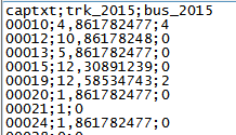
As you can see in the image, the first line tells me that you have only 3 fields. But in the second line you have a number that has a comma separating values (decimal separator?). A csv file generically delimits the information in the table with commas. I modified your original file

enter image description here

First I replaced the original comma to a point, the all the semicolons to commas. Now I am able to open your file in a spreadsheet and look at a table with 3 columns.

If the comma in the original values is a decimal separator you have to tell your operating system that you want the separator to be a point. I know that it could be confusing, but it is the only way your file could be interpreted correctly. Do not forget to include your csvt file also. If the comma is athousands separator, jus get rid of it,

hope it helps

Gerardo

0

Without knowing your data, Did you included the csvt file declaring your field types? look at this:

http://underdark.wordpress.com/2011/03/07/how-to-specify-data-types-of-csv-columns-for-use-in-qgis/

It does work when you are making a join via the layer properties...

Hope it helps

1
  • .csvt is a GDAL-specific solution. I don't think MMQGIS would recognize it.
    – underdark
    Commented Dec 13, 2012 at 12:55

Your Answer

By clicking “Post Your Answer”, you agree to our terms of service and acknowledge you have read our privacy policy.

Not the answer you're looking for? Browse other questions tagged or ask your own question.